Property Record
3619 N 10Th St, Mcallen, TX 78501
Current Lease Availabilities
NEARBY LISTINGS FOR SALE OR LEASE
Property Detail
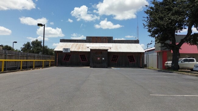
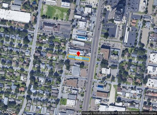
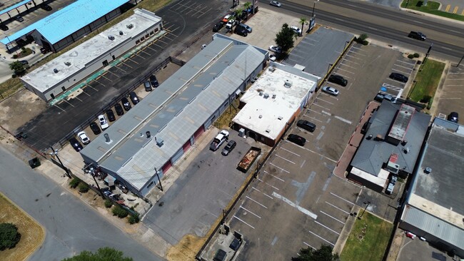
3619 N 10Th St
McAllen/Edinburg/Pharr
North 10Th Community Center - Sml
McAllen-Edinburg-Mission, TX
NORTH 10TH COMMUNITY CENTER LOT 4
N7000-00-000-0004-00
Hidalgo
Commercialnec
Texas
2024
4
2025
0.34 AC
020806
Greater McAllen
4,289 SF
DEMOGRAPHICS near 3619 N 10Th St
1 Mile
3 Mile
5 Mile
2024 Total Population
14,775
110,428
253,881
2029 Population
15,236
114,749
265,184
Pop Growth 2024-2029
+ 3.12%
+ 3.91%
+ 4.45%
Average Age
38
37
36
2024 Total Households
5,875
38,518
84,533
HH Growth 2024-2029
+ 2.98%
+ 3.80%
+ 4.38%
Median Household Inc
$72,189
$60,806
$61,369
Avg Household Size
2.50
2.80
2.90
2024 Avg HH Vehicles
2.00
2.00
2.00
Median Home Value
$231,857
$196,372
$197,762
Median Year Built
1983
1993
1997
Nearby Places
Map Layers
Map Styles
 Street
 Aerial
- Restaurants
- Banks
- Shops
- Fitness
- Groceries
PUBLIC TRANSPORTATION
AIRPORT
McAllen International
DRIVE
WALK
Distance
McAllen International
9 min
4.5 mi
Nearby Properties
Address
Land Use
TOTAL SIZE
Lot Size
Zoning
Address
Land Use
TOTAL SIZE
Lot Size
Zoning
407,190 SF
11.04 AC
CO
Address
Land Use
TOTAL SIZE
Lot Size
Zoning
357,818 SF
11.10 AC
Address
Land Use
TOTAL SIZE
Lot Size
Zoning
390,048 SF
30.30 AC
Address
Land Use
TOTAL SIZE
Lot Size
Zoning
18 SF
82.24 AC
Address
Land Use
TOTAL SIZE
Lot Size
Zoning
263,388 SF
37.48 AC
Address
Land Use
TOTAL SIZE
Lot Size
Zoning
235,545 SF
40.51 AC
Address
Land Use
TOTAL SIZE
Lot Size
Zoning
1 SF
9.36 AC
Address
Land Use
TOTAL SIZE
Lot Size
Zoning
251,423 SF
27.39 AC
CO
Address
Land Use
TOTAL SIZE
Lot Size
Zoning
191,978 SF
2.22 AC
Address
Land Use
TOTAL SIZE
Lot Size
Zoning
252,435 SF
9.09 AC
Address
Land Use
TOTAL SIZE
Lot Size
Zoning
128,076 SF
5.01 AC
Address
Land Use
TOTAL SIZE
Lot Size
Zoning
125,254 SF
15 AC
C
Address
Land Use
TOTAL SIZE
Lot Size
Zoning
254,477 SF
51.88 AC
Address
Land Use
TOTAL SIZE
Lot Size
Zoning
79,150 SF
10.24 AC
Address
Land Use
TOTAL SIZE
Lot Size
Zoning
208,113 SF
22.75 AC
Address
Land Use
TOTAL SIZE
Lot Size
Zoning
173,217 SF
5.58 AC
Address
Land Use
TOTAL SIZE
Lot Size
Zoning
121,353 SF
4.59 AC
Address
Land Use
TOTAL SIZE
Lot Size
Zoning
40,248 SF
10.36 AC
Address
Land Use
TOTAL SIZE
Lot Size
Zoning
66,605 SF
10.05 AC
Address
Land Use
TOTAL SIZE
Lot Size
Zoning
205,008 SF
22.13 AC
Address
Land Use
TOTAL SIZE
Lot Size
Zoning
115,360 SF
4.70 AC
Address
Land Use
TOTAL SIZE
Lot Size
Zoning
16.83 AC
CO
Address
Land Use
TOTAL SIZE
Lot Size
Zoning
108,527 SF
1.49 AC
Address
Land Use
TOTAL SIZE
Lot Size
Zoning
92,603 SF
7.10 AC
CO
Address
Land Use
TOTAL SIZE
Lot Size
Zoning
135,878 SF
15.45 AC
Address
Land Use
TOTAL SIZE
Lot Size
Zoning
90,172 SF
8.71 AC
Address
Land Use
TOTAL SIZE
Lot Size
Zoning
1 SF
7.79 AC
Address
Land Use
TOTAL SIZE
Lot Size
Zoning
82,724 SF
3.27 AC
Address
Land Use
TOTAL SIZE
Lot Size
Zoning
82,448 SF
4.36 AC
Address
Land Use
TOTAL SIZE
Lot Size
Zoning
95,245 SF
8.92 AC
C-3
The World's #1 Commercial Real Estate Marketplace
Connect with us
© 2026 CoStar Group
The information above has been obtained from sources believed reliable. While we do not doubt its accuracy we have not verified it and make no guarantee, warranty or representation about it. It is your responsibility to independently confirm its accuracy and completeness. Any projections, opinions, assumptions, or estimates used are for example only and do not represent the current or future performance of the property. The value of this transaction to you depends on tax and other factors which should be evaluated by your tax, financial, and legal advisors. You and your advisors should conduct a careful, independent investigation of the property to determine to your satisfaction the suitability of the property for your needs.