Property Record
3619 N Elm St, Greensboro, NC 27455

NEARBY LISTINGS FOR SALE OR LEASE
Property Detail
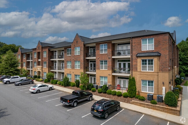
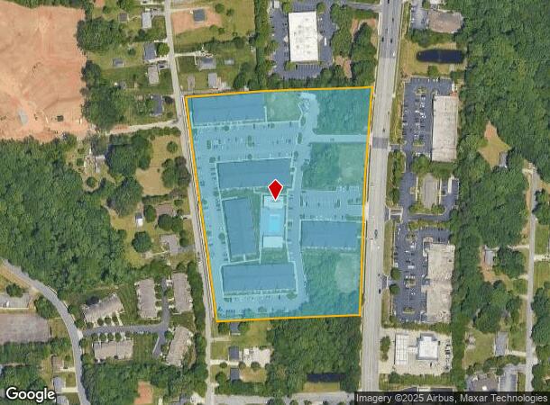
3619 N Elm St
Greensboro-High Point, NC
Bell Orchard Farms
0056579
ENCORE NORTH APTS
Officebuilding
Guilford
X
North Carolina
3710786600J
22
2024
10.53 AC
2025
Outer Guilford
015703
Greensboro/Winston-Salem
142,030 SF
DEMOGRAPHICS near 3619 N Elm St
1 Mile
3 Mile
5 Mile
2024 Total Population
10,027
66,013
156,475
2029 Population
9,932
65,609
156,421
Pop Growth 2024-2029
(0.95%)
(0.61%)
(0.03%)
Average Age
40
40
38
2024 Total Households
4,466
28,610
62,056
HH Growth 2024-2029
(1.01%)
(0.70%)
0.00%
Median Household Inc
$57,852
$62,117
$61,315
Avg Household Size
2.20
2.20
2.20
2024 Avg HH Vehicles
2.00
2.00
2.00
Median Home Value
$207,364
$209,255
$237,748
Median Year Built
1991
1983
1981
Nearby Places
Map Layers
Map Styles
 Street
 Aerial
- Restaurants
- Banks
- Shops
- Fitness
- Groceries
PUBLIC TRANSPORTATION
COMMUTER RAIL
Greensboro Station (Piedmont - North Carolina by Train (NC Train))
DRIVE
WALK
Distance
Greensboro Station (Piedmont - North Carolina by Train (NC Train))
9 min
4.7 mi
AIRPORT
Piedmont Triad International
DRIVE
WALK
Distance
Piedmont Triad International
19 min
11.2 mi
Freight Ports
Virginia Port Authority - Richmond
DRIVE
WALK
Distance
Virginia Port Authority - Richmond
232 min
201.9 mi
Nearby Properties
Address
Land Use
TOTAL SIZE
Lot Size
Zoning
Address
Land Use
TOTAL SIZE
Lot Size
Zoning
646,229 SF
25.47 AC
LI
Address
Land Use
TOTAL SIZE
Lot Size
Zoning
472,566 SF
46.77 AC
RM-12
Address
Land Use
TOTAL SIZE
Lot Size
Zoning
106,706 SF
343.57 AC
PI
Address
Land Use
TOTAL SIZE
Lot Size
Zoning
227,063 SF
6.65 AC
C-H
Address
Land Use
TOTAL SIZE
Lot Size
Zoning
281,337 SF
20.64 AC
PUD
Address
Land Use
TOTAL SIZE
Lot Size
Zoning
222,661 SF
51.39 AC
R-3
Address
Land Use
TOTAL SIZE
Lot Size
Zoning
263,148 SF
32.18 AC
RM-8
Address
Land Use
TOTAL SIZE
Lot Size
Zoning
252,109 SF
8.83 AC
PUD
Address
Land Use
TOTAL SIZE
Lot Size
Zoning
336,133 SF
23.93 AC
CU-RM-12
Address
Land Use
TOTAL SIZE
Lot Size
Zoning
171,358 SF
11.91 AC
PUD
Address
Land Use
TOTAL SIZE
Lot Size
Zoning
223,272 SF
9.91 AC
RM-26
Address
Land Use
TOTAL SIZE
Lot Size
Zoning
302,048 SF
24.45 AC
RM-12
Address
Land Use
TOTAL SIZE
Lot Size
Zoning
138,773 SF
13.90 AC
C-H
Address
Land Use
TOTAL SIZE
Lot Size
Zoning
206,820 SF
14.59 AC
C-H
Address
Land Use
TOTAL SIZE
Lot Size
Zoning
194,064 SF
22.83 AC
RM-12
Address
Land Use
TOTAL SIZE
Lot Size
Zoning
316,644 SF
22.31 AC
RM-12
Address
Land Use
TOTAL SIZE
Lot Size
Zoning
68,100 SF
97.08 AC
R-3
Address
Land Use
TOTAL SIZE
Lot Size
Zoning
270,848 SF
18.28 AC
RM-18
Address
Land Use
TOTAL SIZE
Lot Size
Zoning
214,583 SF
20.64 AC
C-H
Address
Land Use
TOTAL SIZE
Lot Size
Zoning
259,434 SF
23.69 AC
RM-12
Address
Land Use
TOTAL SIZE
Lot Size
Zoning
38,940 SF
19.33 AC
R-3
Address
Land Use
TOTAL SIZE
Lot Size
Zoning
168,798 SF
15.45 AC
RM-12
Address
Land Use
TOTAL SIZE
Lot Size
Zoning
236,995 SF
14.09 AC
RM-18
Address
Land Use
TOTAL SIZE
Lot Size
Zoning
99,926 SF
8.13 AC
O
Address
Land Use
TOTAL SIZE
Lot Size
Zoning
189,979 SF
44.76 AC
PI
Address
Land Use
TOTAL SIZE
Lot Size
Zoning
191,654 SF
11.31 AC
RM-12
Address
Land Use
TOTAL SIZE
Lot Size
Zoning
305,428 SF
13.72 AC
PUD
Address
Land Use
TOTAL SIZE
Lot Size
Zoning
275,083 SF
12.91 AC
RM-18
Address
Land Use
TOTAL SIZE
Lot Size
Zoning
119,780 SF
8.50 AC
PUD
The World's #1 Commercial Real Estate Marketplace
Connect with us
© 2025 CoStar Group
The information above has been obtained from sources believed reliable. While we do not doubt its accuracy we have not verified it and make no guarantee, warranty or representation about it. It is your responsibility to independently confirm its accuracy and completeness. Any projections, opinions, assumptions, or estimates used are for example only and do not represent the current or future performance of the property. The value of this transaction to you depends on tax and other factors which should be evaluated by your tax, financial, and legal advisors. You and your advisors should conduct a careful, independent investigation of the property to determine to your satisfaction the suitability of the property for your needs.