Property Record
3619 Stange Rd, Ames, IA 50010

Save to a Folder
{{folder.Name}}
{{folder.ListingIds.length}} Properties
{{folder.ListingIds.length}} Property
Create a New Folder
Property Detail
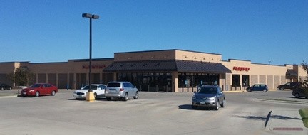
3619 Stange Rd
05-28-273-025
NORTHRIDGE HEIGHTS SD 19TH ADD LOT:1 AMES
Supermarket
STORY
B and X Area of moderate flood hazard, usually the area between the limits of the 100-year and 500-year floods.
Iowa
2025
3.66 AC
2025
North Ames
000102
Other Market Areas
33,225 SF
Ames, IA
NEARBY LISTINGS FOR SALE OR LEASE
DEMOGRAPHICS near 3619 Stange Rd
1 mile
3 mile
5 mile
2025 Total Population
9,015
50,867
74,148
2030 Population
9,132
51,885
75,697
Pop Growth 2025-2030
+ 1.30%
+ 2.00%
+ 2.09%
Average Age
42
34
33
2025 Total Households
3,740
18,213
28,315
HH Growth 2025-2030
+ 1.34%
+ 2.39%
+ 2.53%
Median Household Inc
$101,464
$65,431
$62,975
Avg Household Size
2.30
2.20
2.10
2025 Avg HH Vehicles
2.00
2.00
2.00
Median Home Value
$367,265
$295,711
$298,088
Median Year Built
1999
1982
1991
Nearby Places
Map Layers
Map Styles
 Street
 Aerial
Layers
 Traffic
 Biking
Places
Listings with unknown addresses are not visible on the map
- Restaurants
- Banks
- Shops
- Fitness
- Groceries
Nearby Properties
Address
Land Use
TOTAL SIZE
Lot Size
Zoning
Address
Land Use
TOTAL SIZE
Lot Size
Zoning
2,216 SF
25.86 AC
RH
Address
Land Use
TOTAL SIZE
Lot Size
Zoning
54,112 SF
12.70 AC
Address
Land Use
TOTAL SIZE
Lot Size
Zoning
289,606 SF
1.77 AC
CSC
Address
Land Use
TOTAL SIZE
Lot Size
Zoning
45,627 SF
8.91 AC
RH
Address
Land Use
TOTAL SIZE
Lot Size
Zoning
75,302 SF
16.66 AC
HOC
Address
Land Use
TOTAL SIZE
Lot Size
Zoning
117,797 SF
7.88 AC
Address
Land Use
TOTAL SIZE
Lot Size
Zoning
82,734 SF
1.42 AC
CSC
Address
Land Use
TOTAL SIZE
Lot Size
Zoning
156,833 SF
14.54 AC
PRC
Address
Land Use
TOTAL SIZE
Lot Size
Zoning
16,222 SF
10.44 AC
Address
Land Use
TOTAL SIZE
Lot Size
Zoning
78,379 SF
7.92 AC
SHM
Address
Land Use
TOTAL SIZE
Lot Size
Zoning
133,668 SF
3.71 AC
RH
Address
Land Use
TOTAL SIZE
Lot Size
Zoning
20,619 SF
2.44 AC
RH
Address
Land Use
TOTAL SIZE
Lot Size
Zoning
78,507 SF
3 AC
FS-RM
Address
Land Use
TOTAL SIZE
Lot Size
Zoning
105,550 SF
0.62 AC
CSC
Address
Land Use
TOTAL SIZE
Lot Size
Zoning
7,181 SF
20.11 AC
PRC
Address
Land Use
TOTAL SIZE
Lot Size
Zoning
97,767 SF
0.05 AC
CSC
Address
Land Use
TOTAL SIZE
Lot Size
Zoning
88,584 SF
0.57 AC
Address
Land Use
TOTAL SIZE
Lot Size
Zoning
100,588 SF
7.65 AC
HOC
Address
Land Use
TOTAL SIZE
Lot Size
Zoning
8,820 SF
7.37 AC
PRC
Address
Land Use
TOTAL SIZE
Lot Size
Zoning
22,864 SF
2.13 AC
RH
Address
Land Use
TOTAL SIZE
Lot Size
Zoning
41,000 SF
1.73 AC
Address
Land Use
TOTAL SIZE
Lot Size
Zoning
63,021 SF
3.43 AC
Address
Land Use
TOTAL SIZE
Lot Size
Zoning
20,340 SF
5.66 AC
RH
Address
Land Use
TOTAL SIZE
Lot Size
Zoning
13,200 SF
8.28 AC
Address
Land Use
TOTAL SIZE
Lot Size
Zoning
43,805 SF
4.65 AC
HOC
Address
Land Use
TOTAL SIZE
Lot Size
Zoning
93,977 SF
0.48 AC
Address
Land Use
TOTAL SIZE
Lot Size
Zoning
19,656 SF
4.86 AC
RH
Address
Land Use
TOTAL SIZE
Lot Size
Zoning
23,954 SF
3.77 AC
CCN
Address
Land Use
TOTAL SIZE
Lot Size
Zoning
588 SF
3.04 AC
HOC
Address
Land Use
TOTAL SIZE
Lot Size
Zoning
16,018 SF
3.19 AC
The World's #1 Commercial Real Estate Marketplace
Connect with us
© 2026 CoStar Group
The information above has been obtained from sources believed reliable. While we do not doubt its accuracy we have not verified it and make no guarantee, warranty or representation about it. It is your responsibility to independently confirm its accuracy and completeness. Any projections, opinions, assumptions, or estimates used are for example only and do not represent the current or future performance of the property. The value of this transaction to you depends on tax and other factors which should be evaluated by your tax, financial, and legal advisors. You and your advisors should conduct a careful, independent investigation of the property to determine to your satisfaction the suitability of the property for your needs.