Property Record
3619 Wesley Chapel Rd, Indian Trail, NC 28079
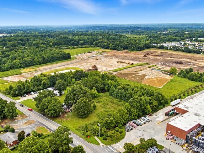
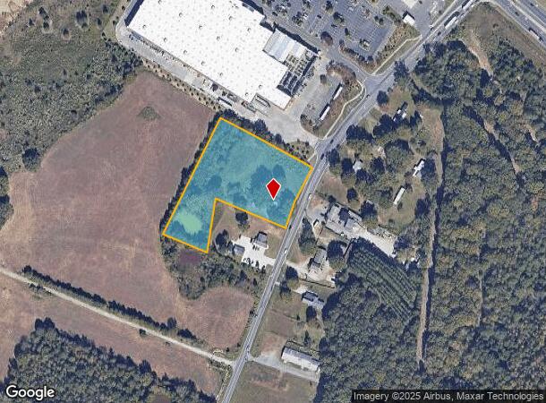
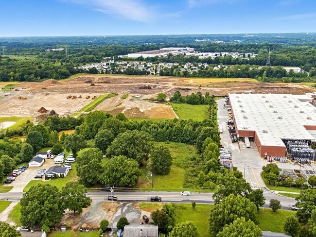
This Property Is For Sale
NEARBY LISTINGS FOR SALE OR LEASE
Property Detail
3619 Wesley Chapel Rd
Charlotte-Concord-Gastonia, NC-SC
Union
07-069-119
North Carolina
Sfr
2.99 AC
X
Union County
3710540800J
Charlotte
908 SF
DEMOGRAPHICS near 3619 Wesley Chapel Rd
1 Mile
3 Mile
5 Mile
2024 Total Population
2,951
42,082
98,572
2029 Population
3,285
47,266
110,357
Pop Growth 2024-2029
+ 11.32%
+ 12.32%
+ 11.96%
Average Age
36
38
39
2024 Total Households
1,072
14,512
34,176
HH Growth 2024-2029
+ 11.47%
+ 12.57%
+ 12.16%
Median Household Inc
$86,375
$84,921
$88,784
Avg Household Size
2.70
2.90
2.90
2024 Avg HH Vehicles
2.00
2.00
2.00
Median Home Value
$249,226
$273,571
$308,005
Median Year Built
1996
2001
2001
Nearby Places
- Restaurants
- Banks
- Shops
- Fitness
- Groceries
PUBLIC TRANSPORTATION
AIRPORT
Charlotte/Douglas International
DRIVE
WALK
Distance
Charlotte/Douglas International
40 min
25.2 mi
Concord-Padgett Regional
DRIVE
WALK
Distance
Concord-Padgett Regional
38 min
29.5 mi
Freight Ports
North Charleston Terminal
DRIVE
WALK
Distance
North Charleston Terminal
231 min
192.4 mi
Nearby Properties
Address
Land Use
TOTAL SIZE
Lot Size
Zoning
Address
Land Use
TOTAL SIZE
Lot Size
Zoning
12.30 AC
SF-1 INDIA
Address
Land Use
TOTAL SIZE
Lot Size
Zoning
18.05 AC
CBD INDIAN
Address
Land Use
TOTAL SIZE
Lot Size
Zoning
8,446 SF
16.89 AC
MFR INDIAN
Address
Land Use
TOTAL SIZE
Lot Size
Zoning
27,900 SF
15.59 AC
MFR INDIAN
Address
Land Use
TOTAL SIZE
Lot Size
Zoning
227,659 SF
26.46 AC
MFR INDIAN
Address
Land Use
TOTAL SIZE
Lot Size
Zoning
166,254 SF
99.20 AC
G-I MONROE
Address
Land Use
TOTAL SIZE
Lot Size
Zoning
83,808 SF
23.45 AC
CD MONROE
Address
Land Use
TOTAL SIZE
Lot Size
Zoning
23.16 AC
CD MONROE
Address
Land Use
TOTAL SIZE
Lot Size
Zoning
498,729 SF
78.21 AC
RBD INDIAN
Address
Land Use
TOTAL SIZE
Lot Size
Zoning
98,929 SF
50.34 AC
SF-1 INDIA
Address
Land Use
TOTAL SIZE
Lot Size
Zoning
49,710 SF
14.20 AC
CZ INDIAN
Address
Land Use
TOTAL SIZE
Lot Size
Zoning
75,923 SF
7.29 AC
SF-1 INDIA
Address
Land Use
TOTAL SIZE
Lot Size
Zoning
159,892 SF
15.84 AC
G-I MONROE
Address
Land Use
TOTAL SIZE
Lot Size
Zoning
103,100 SF
28.55 AC
RBD INDIAN
Address
Land Use
TOTAL SIZE
Lot Size
Zoning
2,968 SF
9.34 AC
R-20 UNION
Address
Land Use
TOTAL SIZE
Lot Size
Zoning
209,960 SF
26.64 AC
RBD INDIAN
Address
Land Use
TOTAL SIZE
Lot Size
Zoning
86,960 SF
14.13 AC
SF-1 INDIA
Address
Land Use
TOTAL SIZE
Lot Size
Zoning
97,318 SF
27.57 AC
RA-40 UNIO
Address
Land Use
TOTAL SIZE
Lot Size
Zoning
79,930 SF
261.95 AC
RBD INDIAN
Address
Land Use
TOTAL SIZE
Lot Size
Zoning
145,600 SF
11.75 AC
G-I MONROE
Address
Land Use
TOTAL SIZE
Lot Size
Zoning
45.21 AC
RBD INDIAN
Address
Land Use
TOTAL SIZE
Lot Size
Zoning
118,802 SF
10.82 AC
G-I MONROE
Address
Land Use
TOTAL SIZE
Lot Size
Zoning
232,678 SF
63 AC
RBD INDIAN
Address
Land Use
TOTAL SIZE
Lot Size
Zoning
13,141 SF
174.76 AC
G-I MONROE
Address
Land Use
TOTAL SIZE
Lot Size
Zoning
45,053 SF
15.03 AC
RBD INDIAN
Address
Land Use
TOTAL SIZE
Lot Size
Zoning
246,033 SF
35 AC
G-I MONROE
Address
Land Use
TOTAL SIZE
Lot Size
Zoning
69,298 SF
10.29 AC
GBD INDIAN
Address
Land Use
TOTAL SIZE
Lot Size
Zoning
15.33 AC
Address
Land Use
TOTAL SIZE
Lot Size
Zoning
139,853 SF
16.30 AC
RBD INDIAN
Address
Land Use
TOTAL SIZE
Lot Size
Zoning
52,379 SF
2.11 AC
GBD INDIAN
The World's #1 Commercial Real Estate Marketplace
Connect with us
© 2025 CoStar Group
The information above has been obtained from sources believed reliable. While we do not doubt its accuracy we have not verified it and make no guarantee, warranty or representation about it. It is your responsibility to independently confirm its accuracy and completeness. Any projections, opinions, assumptions, or estimates used are for example only and do not represent the current or future performance of the property. The value of this transaction to you depends on tax and other factors which should be evaluated by your tax, financial, and legal advisors. You and your advisors should conduct a careful, independent investigation of the property to determine to your satisfaction the suitability of the property for your needs.