Property Record
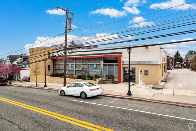
372 E Main St, Collegeville, PA 19426


Current Lease Availabilities
NEARBY LISTINGS FOR SALE OR LEASE
Property Detail
372 E Main St
04-00-01162-004
U 27
Officebuilding
Montgomery
X
Pennsylvania
42029C0065G
26
2024
0.53 AC
2025
West Montgomery County
206300
Philadelphia
11,476 SF
Philadelphia-Camden-Wilmington, PA-NJ-DE-MD
DEMOGRAPHICS near 372 E Main St
1 Mile
3 Mile
5 Mile
2024 Total Population
8,172
40,794
112,397
2029 Population
8,357
41,587
114,339
Pop Growth 2024-2029
+ 2.26%
+ 1.94%
+ 1.73%
Average Age
38
40
41
2024 Total Households
2,659
12,590
39,939
HH Growth 2024-2029
+ 2.18%
+ 2.14%
+ 1.82%
Median Household Inc
$116,935
$145,005
$116,174
Avg Household Size
2.60
2.80
2.60
2024 Avg HH Vehicles
2.00
2.00
2.00
Median Home Value
$408,668
$442,749
$407,853
Median Year Built
1986
1993
1989
Nearby Places
Map Layers
Map Styles
 Street
 Aerial
- Restaurants
- Banks
- Shops
- Fitness
- Groceries
PUBLIC TRANSPORTATION
COMMUTER RAIL
Main Street (Norristown) (R6 - Southeastern Pennsylvania Transportation Authority Regional Rail (SEPTA Regional Rail))
DRIVE
WALK
Distance
Main Street (Norristown) (R6 - Southeastern Pennsylvania Transportation Authority Regional Rail (SEPTA Regional Rail))
16 min
7.8 mi
Elm Street (Norristown) (R6 - Southeastern Pennsylvania Transportation Authority Regional Rail (SEPTA Regional Rail))
DRIVE
WALK
Distance
Elm Street (Norristown) (R6 - Southeastern Pennsylvania Transportation Authority Regional Rail (SEPTA Regional Rail))
17 min
8.0 mi
AIRPORT
Philadelphia International
DRIVE
WALK
Distance
Philadelphia International
59 min
36.4 mi
Trenton Mercer
DRIVE
WALK
Distance
Trenton Mercer
70 min
46.2 mi
Lehigh Valley International
DRIVE
WALK
Distance
Lehigh Valley International
68 min
49.0 mi
Freight Ports
South Jersey Port
DRIVE
WALK
Distance
South Jersey Port
53 min
32.5 mi
Nearby Properties
Address
Land Use
TOTAL SIZE
Lot Size
Zoning
Address
Land Use
TOTAL SIZE
Lot Size
Zoning
1.74 AC
IR
Address
Land Use
TOTAL SIZE
Lot Size
Zoning
975,535 SF
67.40 AC
R2
Address
Land Use
TOTAL SIZE
Lot Size
Zoning
1,113,725 SF
196.05 AC
IO
Address
Land Use
TOTAL SIZE
Lot Size
Zoning
989,814 SF
8.87 AC
IO
Address
Land Use
TOTAL SIZE
Lot Size
Zoning
768,913 SF
81.88 AC
IO
Address
Land Use
TOTAL SIZE
Lot Size
Zoning
1,145,005 SF
149.21 AC
IO
Address
Land Use
TOTAL SIZE
Lot Size
Zoning
124,789 SF
155.99 AC
INO
Address
Land Use
TOTAL SIZE
Lot Size
Zoning
425,899 SF
78.61 AC
R1
Address
Land Use
TOTAL SIZE
Lot Size
Zoning
634,096 SF
3.09 AC
IO
Address
Land Use
TOTAL SIZE
Lot Size
Zoning
199,873 SF
71.47 AC
INO
Address
Land Use
TOTAL SIZE
Lot Size
Zoning
400,875 SF
32.32 AC
IO
Address
Land Use
TOTAL SIZE
Lot Size
Zoning
204,483 SF
25.02 AC
IO
Address
Land Use
TOTAL SIZE
Lot Size
Zoning
160,533 SF
30.50 AC
PRD
Address
Land Use
TOTAL SIZE
Lot Size
Zoning
234,091 SF
53.94 AC
PBO
Address
Land Use
TOTAL SIZE
Lot Size
Zoning
86,046 SF
12.03 AC
R1
Address
Land Use
TOTAL SIZE
Lot Size
Zoning
102,279 SF
17.15 AC
R1
Address
Land Use
TOTAL SIZE
Lot Size
Zoning
98,724 SF
35.50 AC
R1
Address
Land Use
TOTAL SIZE
Lot Size
Zoning
176,130 SF
18.88 AC
C3
Address
Land Use
TOTAL SIZE
Lot Size
Zoning
84,664 SF
14.71 AC
R2
Address
Land Use
TOTAL SIZE
Lot Size
Zoning
98,208 SF
2.26 AC
CRSC
Address
Land Use
TOTAL SIZE
Lot Size
Zoning
137,689 SF
21.46 AC
GC
Address
Land Use
TOTAL SIZE
Lot Size
Zoning
66,894 SF
14.18 AC
R2
Address
Land Use
TOTAL SIZE
Lot Size
Zoning
80,565 SF
9.82 AC
IN
Address
Land Use
TOTAL SIZE
Lot Size
Zoning
88,738 SF
9.63 AC
GA
Address
Land Use
TOTAL SIZE
Lot Size
Zoning
91,633 SF
4.11 AC
R1
Address
Land Use
TOTAL SIZE
Lot Size
Zoning
70,234 SF
24.42 AC
IN
Address
Land Use
TOTAL SIZE
Lot Size
Zoning
124,048 SF
15.62 AC
CC
Address
Land Use
TOTAL SIZE
Lot Size
Zoning
78,911 SF
6.22 AC
IO
Address
Land Use
TOTAL SIZE
Lot Size
Zoning
154,371 SF
27.18 AC
IO
Address
Land Use
TOTAL SIZE
Lot Size
Zoning
114,772 SF
13.60 AC
C1
The World's #1 Commercial Real Estate Marketplace
Connect with us
© 2025 CoStar Group
The information above has been obtained from sources believed reliable. While we do not doubt its accuracy we have not verified it and make no guarantee, warranty or representation about it. It is your responsibility to independently confirm its accuracy and completeness. Any projections, opinions, assumptions, or estimates used are for example only and do not represent the current or future performance of the property. The value of this transaction to you depends on tax and other factors which should be evaluated by your tax, financial, and legal advisors. You and your advisors should conduct a careful, independent investigation of the property to determine to your satisfaction the suitability of the property for your needs.