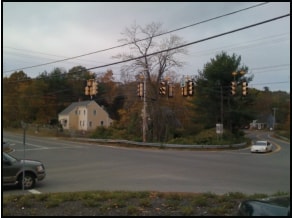
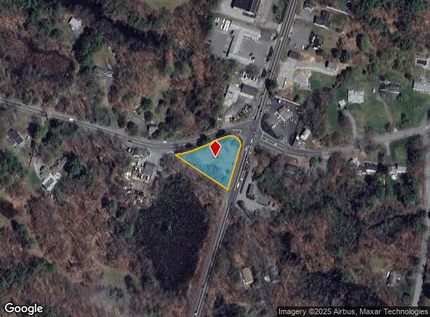
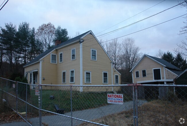
Property Record
362 Boston St, Topsfield, MA 01983

NEARBY LISTINGS FOR SALE OR LEASE
-
-
View all Topsfield listings for sale on LoopNet.com
Property Detail
362 Boston St
METH-001111-000108-A000013B
Essex
Governmentalpublicusegeneral
Massachusetts
AE
13b
25009C0268G
0.56 AC
0
Danvers/Beverly
2025
Boston
214100
Boston-Cambridge-Newton, MA-NH
1,421 SF
DEMOGRAPHICS near 362 Boston St
1 mile
3 mile
5 mile
2024 Total Population
2,429
10,908
41,621
2029 Population
2,433
10,891
41,574
Pop Growth 2024-2029
+ 0.16%
(0.16%)
(0.11%)
Average Age
42
43
43
2024 Total Households
837
3,755
14,692
HH Growth 2024-2029
0.00%
(0.29%)
(0.23%)
Median Household Inc
$155,031
$153,640
$141,420
Avg Household Size
2.90
2.80
2.70
2024 Avg HH Vehicles
2.00
2.00
2.00
Median Home Value
$742,469
$725,368
$703,861
Median Year Built
1970
1970
1971
Nearby Places
Map Layers
Map Styles
 Street
 Aerial
Transit
 Traffic
 Biking
Places
Listings with unknown addresses are not visible on the map
- Restaurants
- Banks
- Shops
- Fitness
- Groceries
PUBLIC TRANSPORTATION
COMMUTER RAIL
Ipswich (Newburyport/Rockport Line - Massachusetts Bay Transportation Authority Commuter Rail (Purple Line))
Drive
Walk
Distance
Ipswich (Newburyport/Rockport Line - Massachusetts Bay Transportation Authority Commuter Rail (Purple Line))
11 min
5.6 mi
Hamilton/Wenham (Newburyport/Rockport Line - Massachusetts Bay Transportation Authority Commuter Rail (Purple Line))
Drive
Walk
Distance
Hamilton/Wenham (Newburyport/Rockport Line - Massachusetts Bay Transportation Authority Commuter Rail (Purple Line))
13 min
6.5 mi
AIRPORT
General Edward Lawrence Logan International
Drive
Walk
Distance
General Edward Lawrence Logan International
37 min
23.1 mi
Portsmouth International at Pease
Drive
Walk
Distance
Portsmouth International at Pease
48 min
34.1 mi
Manchester Boston Regional
Drive
Walk
Distance
Manchester Boston Regional
71 min
42.1 mi
Freight Ports
Port of Boston
Drive
Walk
Distance
Port of Boston
40 min
26.1 mi
Nearby Properties
Address
Land Use
TOTAL SIZE
Lot Size
Zoning
Address
Land Use
TOTAL SIZE
Lot Size
Zoning
374,769 SF
71.70 AC
Address
Land Use
TOTAL SIZE
Lot Size
Zoning
4,047 SF
129.36 AC
EHD
Address
Land Use
TOTAL SIZE
Lot Size
Zoning
1,520 AC
RRA
Address
Land Use
TOTAL SIZE
Lot Size
Zoning
46,504 SF
48 AC
RA
Address
Land Use
TOTAL SIZE
Lot Size
Zoning
284.17 AC
RRA
Address
Land Use
TOTAL SIZE
Lot Size
Zoning
2,176 SF
548.70 AC
RA
Address
Land Use
TOTAL SIZE
Lot Size
Zoning
198.01 AC
ORA
Address
Land Use
TOTAL SIZE
Lot Size
Zoning
108,934 SF
7.64 AC
LI
Address
Land Use
TOTAL SIZE
Lot Size
Zoning
159 AC
RRA
Address
Land Use
TOTAL SIZE
Lot Size
Zoning
1,157 SF
7.62 AC
ORA
Address
Land Use
TOTAL SIZE
Lot Size
Zoning
4,035 SF
760.37 AC
IRA
Address
Land Use
TOTAL SIZE
Lot Size
Zoning
57,011 SF
14.14 AC
IRA
Address
Land Use
TOTAL SIZE
Lot Size
Zoning
8.74 AC
IRA
Address
Land Use
TOTAL SIZE
Lot Size
Zoning
163.54 AC
Address
Land Use
TOTAL SIZE
Lot Size
Zoning
3.70 AC
PC
Address
Land Use
TOTAL SIZE
Lot Size
Zoning
64,500 SF
6.93 AC
PC
Address
Land Use
TOTAL SIZE
Lot Size
Zoning
212.80 AC
RRA
Address
Land Use
TOTAL SIZE
Lot Size
Zoning
53,265 SF
11.29 AC
CR
Address
Land Use
TOTAL SIZE
Lot Size
Zoning
15.20 AC
ORA
Address
Land Use
TOTAL SIZE
Lot Size
Zoning
57,400 SF
7.79 AC
LI
Address
Land Use
TOTAL SIZE
Lot Size
Zoning
61 AC
ORA
Address
Land Use
TOTAL SIZE
Lot Size
Zoning
7.39 AC
CR
Address
Land Use
TOTAL SIZE
Lot Size
Zoning
12,938 SF
2.34 AC
ORA
Address
Land Use
TOTAL SIZE
Lot Size
Zoning
19,665 SF
17.01 AC
PC
Address
Land Use
TOTAL SIZE
Lot Size
Zoning
265.79 AC
RRA
Address
Land Use
TOTAL SIZE
Lot Size
Zoning
6,668 SF
134.89 AC
ORA
Address
Land Use
TOTAL SIZE
Lot Size
Zoning
4.80 AC
BP
Address
Land Use
TOTAL SIZE
Lot Size
Zoning
6,719 SF
15.58 AC
RA
Address
Land Use
TOTAL SIZE
Lot Size
Zoning
2,244 SF
60.40 AC
IRA
Address
Land Use
TOTAL SIZE
Lot Size
Zoning
28 AC
RRA
The World's #1 Commercial Real Estate Marketplace
Connect with us
© 2026 CoStar Group
The information above has been obtained from sources believed reliable. While we do not doubt its accuracy we have not verified it and make no guarantee, warranty or representation about it. It is your responsibility to independently confirm its accuracy and completeness. Any projections, opinions, assumptions, or estimates used are for example only and do not represent the current or future performance of the property. The value of this transaction to you depends on tax and other factors which should be evaluated by your tax, financial, and legal advisors. You and your advisors should conduct a careful, independent investigation of the property to determine to your satisfaction the suitability of the property for your needs.