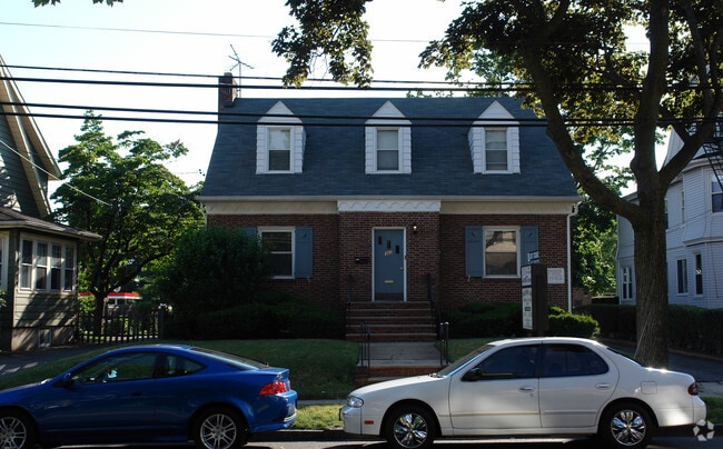
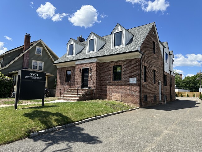
Property Record
362 Franklin St, Bloomfield, NJ 07003

Property Detail
362 Franklin St
02-00301-0000-00028
54 X 179
Commercialofficeresidentialmixeduse
Essex
BCR2
New Jersey
B and X Area of moderate flood hazard, usually the area between the limits of the 100-year and 500-year floods.
28
2024
0.22 AC
2025
Bloomfield/GSP
015400
Northern New Jersey
2,514 SF
Newark, NJ
NEARBY LISTINGS FOR SALE OR LEASE
-
-
-
-
-
-
-
-
-
No Photo
-
-
-
-
View all Bloomfield listings for lease on LoopNet.com
DEMOGRAPHICS near 362 Franklin St
1 mile
3 mile
5 mile
2025 Total Population
37,767
356,415
788,109
2030 Population
39,322
370,123
817,412
Pop Growth 2025-2030
+ 4.12%
+ 3.85%
+ 3.72%
Average Age
40
39
39
2025 Total Households
15,379
135,918
294,074
HH Growth 2025-2030
+ 4.34%
+ 4.11%
+ 4.01%
Median Household Inc
$94,109
$75,692
$78,712
Avg Household Size
2.40
2.50
2.60
2025 Avg HH Vehicles
1.00
1.00
1.00
Median Home Value
$453,106
$450,185
$476,328
Median Year Built
1951
1954
1957
Nearby Places
Map Layers
Map Styles
 Street
 Aerial
Layers
 Traffic
 Biking
Places
Listings with unknown addresses are not visible on the map
- Restaurants
- Banks
- Shops
- Fitness
- Groceries
PUBLIC TRANSPORTATION
COMMUTER RAIL
Bloomfield (Montclair-Boonton Line - NJ Transit Commuter Rail (NJ Transit))
Drive
Walk
Distance
Bloomfield (Montclair-Boonton Line - NJ Transit Commuter Rail (NJ Transit))
1 min
8 min
0.4 mi
Watsessing Avenue (Montclair-Boonton Line - NJ Transit Commuter Rail (NJ Transit))
Drive
Walk
Distance
Watsessing Avenue (Montclair-Boonton Line - NJ Transit Commuter Rail (NJ Transit))
2 min
17 min
0.9 mi
AIRPORT
Newark Liberty International
Drive
Walk
Distance
Newark Liberty International
16 min
9.7 mi
LaGuardia
Drive
Walk
Distance
LaGuardia
44 min
25.5 mi
John F Kennedy International
Drive
Walk
Distance
John F Kennedy International
52 min
33.6 mi
Freight Ports
Port Newark Container Terminal
Drive
Walk
Distance
Port Newark Container Terminal
19 min
9.5 mi
SALE & LEASE HISTORY
LISTING DATE
SALE/LEASE

Sep 03, 2024
For Lease
Dec 18, 2024
For Lease
Apr 29, 2025
For Lease
Nearby Properties
Address
Land Use
TOTAL SIZE
Lot Size
Zoning
Address
Land Use
TOTAL SIZE
Lot Size
Zoning
5 AC
H
Address
Land Use
TOTAL SIZE
Lot Size
Zoning
17.97 AC
Address
Land Use
TOTAL SIZE
Lot Size
Zoning
Address
Land Use
TOTAL SIZE
Lot Size
Zoning
0.13 AC
Address
Land Use
TOTAL SIZE
Lot Size
Zoning
16,084 SF
7.23 AC
Address
Land Use
TOTAL SIZE
Lot Size
Zoning
1,589 SF
0.22 AC
R4
Address
Land Use
TOTAL SIZE
Lot Size
Zoning
12.54 AC
OPRP
Address
Land Use
TOTAL SIZE
Lot Size
Zoning
3.31 AC
Address
Land Use
TOTAL SIZE
Lot Size
Zoning
0.24 AC
R4
Address
Land Use
TOTAL SIZE
Lot Size
Zoning
2.64 AC
Address
Land Use
TOTAL SIZE
Lot Size
Zoning
4.92 AC
Address
Land Use
TOTAL SIZE
Lot Size
Zoning
Address
Land Use
TOTAL SIZE
Lot Size
Zoning
4.33 AC
Address
Land Use
TOTAL SIZE
Lot Size
Zoning
11.49 AC
M-1
Address
Land Use
TOTAL SIZE
Lot Size
Zoning
298,272 SF
31.36 AC
P-6
Address
Land Use
TOTAL SIZE
Lot Size
Zoning
7.03 AC
Address
Land Use
TOTAL SIZE
Lot Size
Zoning
306,414 SF
4.62 AC
Address
Land Use
TOTAL SIZE
Lot Size
Zoning
3.26 AC
PR
Address
Land Use
TOTAL SIZE
Lot Size
Zoning
0.17 AC
BCR1
Address
Land Use
TOTAL SIZE
Lot Size
Zoning
2.22 AC
OB-2
Address
Land Use
TOTAL SIZE
Lot Size
Zoning
1.67 AC
BCR1
Address
Land Use
TOTAL SIZE
Lot Size
Zoning
3.28 AC
Address
Land Use
TOTAL SIZE
Lot Size
Zoning
3.20 AC
BSRD
Address
Land Use
TOTAL SIZE
Lot Size
Zoning
224 SF
0.94 AC
BCR1
Address
Land Use
TOTAL SIZE
Lot Size
Zoning
1.50 AC
RA
Address
Land Use
TOTAL SIZE
Lot Size
Zoning
1.95 AC
RA
Address
Land Use
TOTAL SIZE
Lot Size
Zoning
3.64 AC
R-M
Address
Land Use
TOTAL SIZE
Lot Size
Zoning
11,296 SF
17.50 AC
R-G
Address
Land Use
TOTAL SIZE
Lot Size
Zoning
9.98 AC
R-1
Address
Land Use
TOTAL SIZE
Lot Size
Zoning
302 SF
77.28 AC
The World's #1 Commercial Real Estate Marketplace
Connect with us
© 2026 CoStar Group
The information above has been obtained from sources believed reliable. While we do not doubt its accuracy we have not verified it and make no guarantee, warranty or representation about it. It is your responsibility to independently confirm its accuracy and completeness. Any projections, opinions, assumptions, or estimates used are for example only and do not represent the current or future performance of the property. The value of this transaction to you depends on tax and other factors which should be evaluated by your tax, financial, and legal advisors. You and your advisors should conduct a careful, independent investigation of the property to determine to your satisfaction the suitability of the property for your needs.