Property Record
3620 Freedom Rd, Trinidad, CO 81082
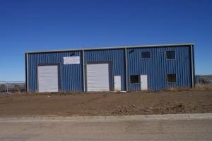

Property Detail
3620 Freedom Rd
10381300
TRINIDAD INDUSTRIAL PARK SUB-DIV SECOND FILING SITE-36- CONT-2.17 ACRS M/L LOCATED IN PT-E2-31-32-63
Commercialnec
Las Animas
B and X Area of moderate flood hazard, usually the area between the limits of the 100-year and 500-year floods.
Colorado
0
36
2025
2.17 AC
000800
Colorado East Area
4,000 SF
Other Market Areas
NEARBY LISTINGS FOR SALE OR LEASE
DEMOGRAPHICS near 3620 Freedom Rd
1 mile
3 mile
5 mile
2025 Total Population
1,160
8,132
9,458
2030 Population
1,133
8,015
9,343
Pop Growth 2025-2030
(2.33%)
(1.44%)
(1.22%)
Average Age
42
44
44
2025 Total Households
520
3,633
4,215
HH Growth 2025-2030
(2.50%)
(1.54%)
(1.35%)
Median Household Inc
$24,999
$53,459
$55,756
Avg Household Size
2.20
2.10
2.10
2025 Avg HH Vehicles
2.00
2.00
2.00
Median Home Value
$168,817
$209,756
$226,514
Median Year Built
1965
1958
1962
Nearby Places
Map Layers
Map Styles
 Street
 Aerial
Layers
 Traffic
 Biking
Places
Listings with unknown addresses are not visible on the map
- Restaurants
- Banks
- Shops
- Fitness
- Groceries
PUBLIC TRANSPORTATION
COMMUTER RAIL
Trinidad Amtrak (Southwest Chief - Amtrak)
Drive
Walk
Distance
Trinidad Amtrak (Southwest Chief - Amtrak)
9 min
5.4 mi
Freight Ports
Tulsa Port Of Catoosa
Drive
Walk
Distance
Tulsa Port Of Catoosa
655 min
559.1 mi
Nearby Properties
Address
Land Use
TOTAL SIZE
Lot Size
Zoning
Address
Land Use
TOTAL SIZE
Lot Size
Zoning
22.44 AC
Address
Land Use
TOTAL SIZE
Lot Size
Zoning
39,979 SF
4.50 AC
Address
Land Use
TOTAL SIZE
Lot Size
Zoning
2,020 SF
7.26 AC
Address
Land Use
TOTAL SIZE
Lot Size
Zoning
2,160 SF
0.35 AC
Address
Land Use
TOTAL SIZE
Lot Size
Zoning
5.57 AC
Address
Land Use
TOTAL SIZE
Lot Size
Zoning
Address
Land Use
TOTAL SIZE
Lot Size
Zoning
0.11 AC
Address
Land Use
TOTAL SIZE
Lot Size
Zoning
18,680 SF
100.39 AC
Address
Land Use
TOTAL SIZE
Lot Size
Zoning
Address
Land Use
TOTAL SIZE
Lot Size
Zoning
33.50 AC
Address
Land Use
TOTAL SIZE
Lot Size
Zoning
60,014 SF
6.57 AC
Address
Land Use
TOTAL SIZE
Lot Size
Zoning
Address
Land Use
TOTAL SIZE
Lot Size
Zoning
Address
Land Use
TOTAL SIZE
Lot Size
Zoning
1 SF
43.22 AC
Address
Land Use
TOTAL SIZE
Lot Size
Zoning
17,503 SF
0.40 AC
Address
Land Use
TOTAL SIZE
Lot Size
Zoning
41,984 SF
4.18 AC
Address
Land Use
TOTAL SIZE
Lot Size
Zoning
0.29 AC
Address
Land Use
TOTAL SIZE
Lot Size
Zoning
0.81 AC
Address
Land Use
TOTAL SIZE
Lot Size
Zoning
Address
Land Use
TOTAL SIZE
Lot Size
Zoning
83,846 SF
19.10 AC
Address
Land Use
TOTAL SIZE
Lot Size
Zoning
12.76 AC
Address
Land Use
TOTAL SIZE
Lot Size
Zoning
9,770 SF
4.19 AC
Address
Land Use
TOTAL SIZE
Lot Size
Zoning
Address
Land Use
TOTAL SIZE
Lot Size
Zoning
16,352 SF
0.95 AC
Address
Land Use
TOTAL SIZE
Lot Size
Zoning
52,460 SF
4.48 AC
Address
Land Use
TOTAL SIZE
Lot Size
Zoning
0.11 AC
Address
Land Use
TOTAL SIZE
Lot Size
Zoning
2.52 AC
Address
Land Use
TOTAL SIZE
Lot Size
Zoning
10,538 SF
0.75 AC
Address
Land Use
TOTAL SIZE
Lot Size
Zoning
22,445 SF
15.42 AC
The World's #1 Commercial Real Estate Marketplace
Connect with us
© 2026 CoStar Group
The information above has been obtained from sources believed reliable. While we do not doubt its accuracy we have not verified it and make no guarantee, warranty or representation about it. It is your responsibility to independently confirm its accuracy and completeness. Any projections, opinions, assumptions, or estimates used are for example only and do not represent the current or future performance of the property. The value of this transaction to you depends on tax and other factors which should be evaluated by your tax, financial, and legal advisors. You and your advisors should conduct a careful, independent investigation of the property to determine to your satisfaction the suitability of the property for your needs.