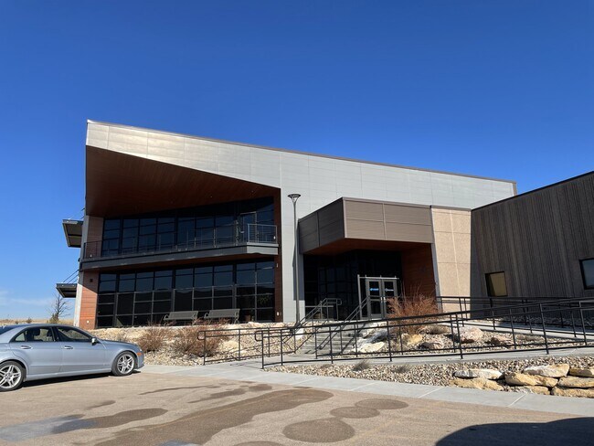
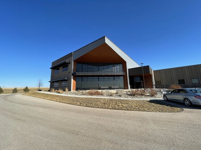
Property Record
3620 Homestead St, Rapid City, SD 57703

NEARBY LISTINGS FOR SALE OR LEASE
Property Detail
3620 Homestead St
Rapid City, SD
Rushmore Business Park
3804226004
RUSHMORE BUSINESS PARK, BLOCK 4, LOT 3R
Publicstorage
Pennington
D
South Dakota
46103C0784H
3r
0
3.36 AC
2025
Rapid City
010906
Other Market Areas
13,377 SF
DEMOGRAPHICS near 3620 Homestead St
1 Mile
3 Mile
5 Mile
2024 Total Population
4,183
30,458
71,611
2029 Population
4,793
34,198
80,001
Pop Growth 2024-2029
+ 14.58%
+ 12.28%
+ 11.72%
Average Age
37
38
40
2024 Total Households
1,591
12,230
29,052
HH Growth 2024-2029
+ 14.96%
+ 12.76%
+ 12.08%
Median Household Inc
$85,688
$59,543
$58,641
Avg Household Size
2.60
2.30
2.30
2024 Avg HH Vehicles
2.00
2.00
2.00
Median Home Value
$256,512
$213,355
$227,105
Median Year Built
2005
1989
1984
Nearby Places
Map Layers
Map Styles
 Street
 Aerial
- Restaurants
- Banks
- Shops
- Fitness
- Groceries
PUBLIC TRANSPORTATION
AIRPORT
Rapid City Regional
DRIVE
WALK
Distance
Rapid City Regional
14 min
8.2 mi
Freight Ports
Tulsa Port Of Catoosa
DRIVE
WALK
Distance
Tulsa Port Of Catoosa
964 min
886.7 mi
SALE & LEASE HISTORY
LISTING DATE
SALE/LEASE

Feb 05, 2024
For Lease
Nearby Properties
Address
Land Use
TOTAL SIZE
Lot Size
Zoning
Address
Land Use
TOTAL SIZE
Lot Size
Zoning
19,781 SF
11.03 AC
Address
Land Use
TOTAL SIZE
Lot Size
Zoning
4,748 SF
9.94 AC
Address
Land Use
TOTAL SIZE
Lot Size
Zoning
6,480 SF
11.58 AC
Address
Land Use
TOTAL SIZE
Lot Size
Zoning
5,448 SF
8 AC
Address
Land Use
TOTAL SIZE
Lot Size
Zoning
2,632 SF
8.11 AC
Address
Land Use
TOTAL SIZE
Lot Size
Zoning
14,484 SF
5.20 AC
Address
Land Use
TOTAL SIZE
Lot Size
Zoning
55,442 SF
23.96 AC
Address
Land Use
TOTAL SIZE
Lot Size
Zoning
4,005 SF
12.09 AC
Address
Land Use
TOTAL SIZE
Lot Size
Zoning
38,030 SF
13.47 AC
Address
Land Use
TOTAL SIZE
Lot Size
Zoning
188,360 SF
37.53 AC
Address
Land Use
TOTAL SIZE
Lot Size
Zoning
2,018 SF
5.66 AC
Address
Land Use
TOTAL SIZE
Lot Size
Zoning
46,644 SF
11.89 AC
Address
Land Use
TOTAL SIZE
Lot Size
Zoning
2,865 SF
7.08 AC
Address
Land Use
TOTAL SIZE
Lot Size
Zoning
28,584 SF
5.62 AC
Address
Land Use
TOTAL SIZE
Lot Size
Zoning
28,894 SF
2.17 AC
Address
Land Use
TOTAL SIZE
Lot Size
Zoning
714 SF
11.14 AC
Address
Land Use
TOTAL SIZE
Lot Size
Zoning
29,196 SF
3.89 AC
Address
Land Use
TOTAL SIZE
Lot Size
Zoning
147,325 SF
11.93 AC
Address
Land Use
TOTAL SIZE
Lot Size
Zoning
162,960 SF
22.56 AC
Address
Land Use
TOTAL SIZE
Lot Size
Zoning
227,112 SF
21.01 AC
Address
Land Use
TOTAL SIZE
Lot Size
Zoning
45,485 SF
9.84 AC
Address
Land Use
TOTAL SIZE
Lot Size
Zoning
118,800 SF
40.85 AC
Address
Land Use
TOTAL SIZE
Lot Size
Zoning
21,735 SF
11.60 AC
Address
Land Use
TOTAL SIZE
Lot Size
Zoning
27,300 SF
70.55 AC
Address
Land Use
TOTAL SIZE
Lot Size
Zoning
2,018 SF
3.73 AC
Address
Land Use
TOTAL SIZE
Lot Size
Zoning
24,297 SF
5.15 AC
Address
Land Use
TOTAL SIZE
Lot Size
Zoning
2,058 SF
3.60 AC
Address
Land Use
TOTAL SIZE
Lot Size
Zoning
65,922 SF
6 AC
Address
Land Use
TOTAL SIZE
Lot Size
Zoning
20,988 SF
4.13 AC
The World's #1 Commercial Real Estate Marketplace
Connect with us
© 2026 CoStar Group
The information above has been obtained from sources believed reliable. While we do not doubt its accuracy we have not verified it and make no guarantee, warranty or representation about it. It is your responsibility to independently confirm its accuracy and completeness. Any projections, opinions, assumptions, or estimates used are for example only and do not represent the current or future performance of the property. The value of this transaction to you depends on tax and other factors which should be evaluated by your tax, financial, and legal advisors. You and your advisors should conduct a careful, independent investigation of the property to determine to your satisfaction the suitability of the property for your needs.