Property Record
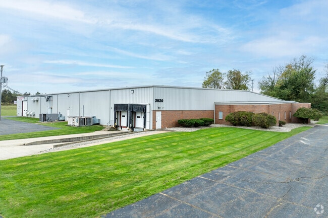
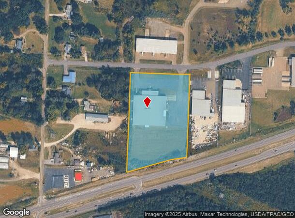
3620 Progress St Ne, Canton, OH 44705

Property Detail
3620 Progress St Ne
00305772
OL 972 - 4.64A
Lightindustrial
Stark
X
Ohio
39151C0229E
4.64 AC
0
Stark County
2025
Cleveland
712400
Canton-Massillon, OH
39,000 SF
NEARBY LISTINGS FOR SALE OR LEASE
DEMOGRAPHICS near 3620 Progress St Ne
1 mile
3 mile
5 mile
2024 Total Population
3,971
40,924
110,496
2029 Population
3,977
40,682
110,032
Pop Growth 2024-2029
+ 0.15%
(0.59%)
(0.42%)
Average Age
40
41
41
2024 Total Households
1,486
16,875
46,384
HH Growth 2024-2029
+ 0.34%
(0.64%)
(0.46%)
Median Household Inc
$44,356
$54,648
$51,129
Avg Household Size
2.30
2.30
2.30
2024 Avg HH Vehicles
2.00
2.00
2.00
Median Home Value
$110,800
$143,561
$149,903
Median Year Built
1968
1962
1960
Nearby Places
Map Layers
Map Styles
 Street
 Aerial
Transit
 Traffic
 Biking
Places
Listings with unknown addresses are not visible on the map
- Restaurants
- Banks
- Shops
- Fitness
- Groceries
PUBLIC TRANSPORTATION
AIRPORT
Akron-Canton Regional
Drive
Walk
Distance
Akron-Canton Regional
18 min
12.0 mi
SALE & LEASE HISTORY
LISTING DATE
SALE/LEASE

Jun 08, 2023
For Sale
Feb 14, 2025
For Sale
Aug 28, 2024
For Lease
Nearby Properties
Address
Land Use
TOTAL SIZE
Lot Size
Zoning
Address
Land Use
TOTAL SIZE
Lot Size
Zoning
91.83 AC
Address
Land Use
TOTAL SIZE
Lot Size
Zoning
125,619 SF
13.15 AC
Address
Land Use
TOTAL SIZE
Lot Size
Zoning
272,327 SF
23.62 AC
Address
Land Use
TOTAL SIZE
Lot Size
Zoning
1,069,826 SF
158.31 AC
Address
Land Use
TOTAL SIZE
Lot Size
Zoning
118,889 SF
19.77 AC
Address
Land Use
TOTAL SIZE
Lot Size
Zoning
116,904 SF
55.51 AC
Address
Land Use
TOTAL SIZE
Lot Size
Zoning
476,634 SF
15.08 AC
Address
Land Use
TOTAL SIZE
Lot Size
Zoning
681,718 SF
35.20 AC
Address
Land Use
TOTAL SIZE
Lot Size
Zoning
202,684 SF
40.97 AC
Address
Land Use
TOTAL SIZE
Lot Size
Zoning
133,991 SF
24.51 AC
Address
Land Use
TOTAL SIZE
Lot Size
Zoning
1,096,089 SF
144.96 AC
Address
Land Use
TOTAL SIZE
Lot Size
Zoning
180,088 SF
71.80 AC
Address
Land Use
TOTAL SIZE
Lot Size
Zoning
153,834 SF
20.21 AC
Address
Land Use
TOTAL SIZE
Lot Size
Zoning
145,719 SF
43.60 AC
Address
Land Use
TOTAL SIZE
Lot Size
Zoning
217,695 SF
19.46 AC
Address
Land Use
TOTAL SIZE
Lot Size
Zoning
135,840 SF
21 AC
Address
Land Use
TOTAL SIZE
Lot Size
Zoning
58,021 SF
13.25 AC
Address
Land Use
TOTAL SIZE
Lot Size
Zoning
52,876 SF
4.96 AC
Address
Land Use
TOTAL SIZE
Lot Size
Zoning
118,052 SF
12.52 AC
Address
Land Use
TOTAL SIZE
Lot Size
Zoning
81,369 SF
3 AC
Address
Land Use
TOTAL SIZE
Lot Size
Zoning
469,300 SF
23.27 AC
Address
Land Use
TOTAL SIZE
Lot Size
Zoning
1,083,703 SF
91.83 AC
Address
Land Use
TOTAL SIZE
Lot Size
Zoning
101,463 SF
8.85 AC
Address
Land Use
TOTAL SIZE
Lot Size
Zoning
346,390 SF
28.89 AC
Address
Land Use
TOTAL SIZE
Lot Size
Zoning
35,179 SF
5.06 AC
Address
Land Use
TOTAL SIZE
Lot Size
Zoning
68,419 SF
8.93 AC
Address
Land Use
TOTAL SIZE
Lot Size
Zoning
187,797 SF
20.29 AC
Address
Land Use
TOTAL SIZE
Lot Size
Zoning
14,070 SF
10.04 AC
Address
Land Use
TOTAL SIZE
Lot Size
Zoning
19,129 SF
41.96 AC
Address
Land Use
TOTAL SIZE
Lot Size
Zoning
117,239 SF
14.13 AC
The World's #1 Commercial Real Estate Marketplace
Connect with us
© 2026 CoStar Group
The information above has been obtained from sources believed reliable. While we do not doubt its accuracy we have not verified it and make no guarantee, warranty or representation about it. It is your responsibility to independently confirm its accuracy and completeness. Any projections, opinions, assumptions, or estimates used are for example only and do not represent the current or future performance of the property. The value of this transaction to you depends on tax and other factors which should be evaluated by your tax, financial, and legal advisors. You and your advisors should conduct a careful, independent investigation of the property to determine to your satisfaction the suitability of the property for your needs.