Property Record
3620 Route 9, Cold Spring, NY 10516
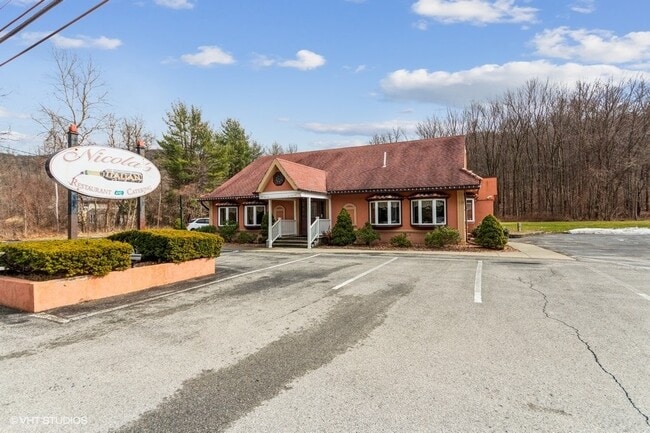


This Property Is For Sale
Property Detail
3620 Route 9
372689-017-000-0001-045-000-0000
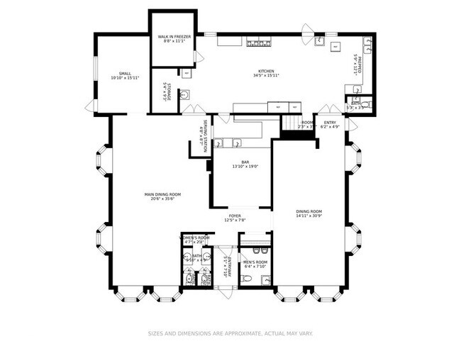
LAND & RESTAURANT
Restaurantbuilding
Putnam
I
New York
B and X Area of moderate flood hazard, usually the area between the limits of the 100-year and 500-year floods.
45.00
2024
1 AC
2024
Carmel
010600
Westchester/So Connecticut
5,884 SF
New York-Jersey City-White Plains, NY-NJ
NEARBY LISTINGS FOR SALE OR LEASE
DEMOGRAPHICS near 3620 Route 9
1 mile
3 mile
5 mile
2025 Total Population
675
9,806
43,105
2030 Population
682
9,806
43,327
Pop Growth 2025-2030
+ 1.04%
0.00%
+ 0.52%
Average Age
48
45
44
2025 Total Households
282
4,100
17,483
HH Growth 2025-2030
+ 0.71%
(0.15%)
+ 0.48%
Median Household Inc
$122,499
$100,301
$98,265
Avg Household Size
2.30
2.30
2.30
2025 Avg HH Vehicles
2.00
2.00
2.00
Median Home Value
$698,795
$469,825
$454,706
Median Year Built
1984
1971
1975
Nearby Places
Map Layers
Map Styles
 Street
 Aerial
Transit
 Traffic
 Biking
Places
Listings with unknown addresses are not visible on the map
- Restaurants
- Banks
- Shops
- Fitness
- Groceries
PUBLIC TRANSPORTATION
COMMUTER RAIL
Cold Spring Station (Hudson Line - Metro-North Commuter Railroad Company (Metro-North))
Drive
Walk
Distance
Cold Spring Station (Hudson Line - Metro-North Commuter Railroad Company (Metro-North))
11 min
6.8 mi
Breakneck Ridge Station (Hudson Line - Metro-North Commuter Railroad Company (Metro-North))
Drive
Walk
Distance
Breakneck Ridge Station (Hudson Line - Metro-North Commuter Railroad Company (Metro-North))
13 min
8.8 mi
AIRPORT
New York Stewart International
Drive
Walk
Distance
New York Stewart International
27 min
17.5 mi
Westchester County
Drive
Walk
Distance
Westchester County
58 min
43.7 mi
Nearby Properties
Address
Land Use
TOTAL SIZE
Lot Size
Zoning
Address
Land Use
TOTAL SIZE
Lot Size
Zoning
36.65 AC
R1-20
Address
Land Use
TOTAL SIZE
Lot Size
Zoning
56,704 SF
5.03 AC
PSC
Address
Land Use
TOTAL SIZE
Lot Size
Zoning
248,686 SF
0.01 AC
PSC
Address
Land Use
TOTAL SIZE
Lot Size
Zoning
206,064 SF
31.72 AC
PI
Address
Land Use
TOTAL SIZE
Lot Size
Zoning
6.30 AC
PSC
Address
Land Use
TOTAL SIZE
Lot Size
Zoning
99,569 SF
16.10 AC
PSC
Address
Land Use
TOTAL SIZE
Lot Size
Zoning
72,222 SF
7.62 AC
PSC
Address
Land Use
TOTAL SIZE
Lot Size
Zoning
12 AC
R1-10
Address
Land Use
TOTAL SIZE
Lot Size
Zoning
27,472 SF
0.67 AC
LI
Address
Land Use
TOTAL SIZE
Lot Size
Zoning
32,347 SF
17.10 AC
R20
Address
Land Use
TOTAL SIZE
Lot Size
Zoning
133,362 SF
18.85 AC
PSC
Address
Land Use
TOTAL SIZE
Lot Size
Zoning
38,699 SF
3.09 AC
GB
Address
Land Use
TOTAL SIZE
Lot Size
Zoning
117,740 SF
6.34 AC
PSC
Address
Land Use
TOTAL SIZE
Lot Size
Zoning
8,960 SF
6.28 AC
PSC
Address
Land Use
TOTAL SIZE
Lot Size
Zoning
49.90 AC
GB
Address
Land Use
TOTAL SIZE
Lot Size
Zoning
47,968 SF
5.19 AC
GB
Address
Land Use
TOTAL SIZE
Lot Size
Zoning
132,874 SF
13.49 AC
GB
Address
Land Use
TOTAL SIZE
Lot Size
Zoning
109,900 SF
11.17 AC
PB
Address
Land Use
TOTAL SIZE
Lot Size
Zoning
98,993 SF
3.52 AC
PSC
Address
Land Use
TOTAL SIZE
Lot Size
Zoning
47,474 SF
8.07 AC
HI
Address
Land Use
TOTAL SIZE
Lot Size
Zoning
45,867 SF
3.20 AC
PSC
Address
Land Use
TOTAL SIZE
Lot Size
Zoning
494.40 AC
R4A
Address
Land Use
TOTAL SIZE
Lot Size
Zoning
144,000 SF
10.33 AC
HI
Address
Land Use
TOTAL SIZE
Lot Size
Zoning
61,889 SF
4.81 AC
PSC
Address
Land Use
TOTAL SIZE
Lot Size
Zoning
108,474 SF
6.78 AC
PI
Address
Land Use
TOTAL SIZE
Lot Size
Zoning
55,085 SF
10.40 AC
RMF5
Address
Land Use
TOTAL SIZE
Lot Size
Zoning
38,976 SF
1.93 AC
PSC
Address
Land Use
TOTAL SIZE
Lot Size
Zoning
57,500 SF
6.61 AC
PI
Address
Land Use
TOTAL SIZE
Lot Size
Zoning
300 AC
R4A
Address
Land Use
TOTAL SIZE
Lot Size
Zoning
49,712 SF
2.04 AC
PI
The World's #1 Commercial Real Estate Marketplace
Connect with us
© 2026 CoStar Group
The information above has been obtained from sources believed reliable. While we do not doubt its accuracy we have not verified it and make no guarantee, warranty or representation about it. It is your responsibility to independently confirm its accuracy and completeness. Any projections, opinions, assumptions, or estimates used are for example only and do not represent the current or future performance of the property. The value of this transaction to you depends on tax and other factors which should be evaluated by your tax, financial, and legal advisors. You and your advisors should conduct a careful, independent investigation of the property to determine to your satisfaction the suitability of the property for your needs.