Property Record
3620 Smith Ave, Acton, CA 93510
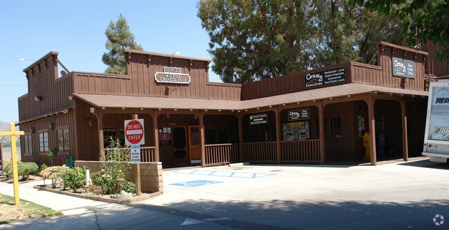

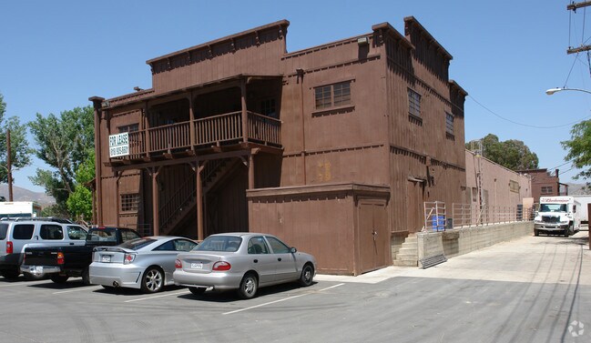

Property Detail
3620 Smith Ave
3208-014-102
MR 52-7 VAC ALLEY,LOTS 1 THRU 4,7,8,9,15 AND POR LOTS 5,6,10 THRU 13 BLK 1
Storemultistory
LOS ANGELES
C4
California
AE The base floodplain where base flood elevations are provided. AE Zones are now used on new format FIRMs instead of A1-A30 Zones.
1-13
2024
2.28 AC
2025
Antelope Valley
910815
Los Angeles
39,654 SF
Los Angeles-Long Beach-Glendale, CA
NEARBY LISTINGS FOR SALE OR LEASE
DEMOGRAPHICS near 3620 Smith Ave
1 mile
3 mile
5 mile
2025 Total Population
960
4,648
7,637
2030 Population
958
4,622
7,590
Pop Growth 2025-2030
(0.21%)
(0.56%)
(0.62%)
Average Age
45
46
45
2025 Total Households
354
1,685
2,739
HH Growth 2025-2030
(0.56%)
(0.77%)
(0.84%)
Median Household Inc
$107,692
$109,301
$115,129
Avg Household Size
2.70
2.70
2.70
2025 Avg HH Vehicles
3.00
3.00
3.00
Median Home Value
$743,455
$754,385
$765,758
Median Year Built
1983
1985
1985
Nearby Places
Map Layers
Map Styles
 Street
 Aerial
Layers
 Traffic
 Biking
Places
Listings with unknown addresses are not visible on the map
- Restaurants
- Banks
- Shops
- Fitness
- Groceries
PUBLIC TRANSPORTATION
COMMUTER RAIL
Vincent Grade/Acton (Antelope Valley Line - Southern California Regional Rail Authority (Metrolink))
Drive
Walk
Distance
Vincent Grade/Acton (Antelope Valley Line - Southern California Regional Rail Authority (Metrolink))
10 min
5.3 mi
AIRPORT
Bob Hope
Drive
Walk
Distance
Bob Hope
47 min
39.0 mi
Freight Ports
Port of Long Beach
Drive
Walk
Distance
Port of Long Beach
90 min
75.4 mi
Nearby Properties
Address
Land Use
TOTAL SIZE
Lot Size
Zoning
Address
Land Use
TOTAL SIZE
Lot Size
Zoning
14,480 SF
137.61 AC
LCRR1*
Address
Land Use
TOTAL SIZE
Lot Size
Zoning
134,189 SF
11.43 AC
LCM1
Address
Land Use
TOTAL SIZE
Lot Size
Zoning
342,675 SF
9.09 AC
LCC4-R3*
Address
Land Use
TOTAL SIZE
Lot Size
Zoning
35,880 SF
2.89 AC
LCC4
Address
Land Use
TOTAL SIZE
Lot Size
Zoning
6,200 SF
71.97 AC
LCA21*
Address
Land Use
TOTAL SIZE
Lot Size
Zoning
5,010 SF
0.74 AC
LCC4*
Address
Land Use
TOTAL SIZE
Lot Size
Zoning
2,497 SF
2.01 AC
LCC2*
Address
Land Use
TOTAL SIZE
Lot Size
Zoning
570 SF
39.78 AC
LCRR1*
Address
Land Use
TOTAL SIZE
Lot Size
Zoning
17,108 SF
1.80 AC
LCC4-A1100
Address
Land Use
TOTAL SIZE
Lot Size
Zoning
7,500 SF
0.65 AC
LCC4*
Address
Land Use
TOTAL SIZE
Lot Size
Zoning
2,808 SF
0.73 AC
LCC4-A1100
Address
Land Use
TOTAL SIZE
Lot Size
Zoning
4.64 AC
LCC2*
Address
Land Use
TOTAL SIZE
Lot Size
Zoning
7,500 SF
0.67 AC
LCC-RU
Address
Land Use
TOTAL SIZE
Lot Size
Zoning
2,628 SF
37.90 AC
LCA2 5
Address
Land Use
TOTAL SIZE
Lot Size
Zoning
1,375 SF
0.68 AC
LCC4-A1100
Address
Land Use
TOTAL SIZE
Lot Size
Zoning
2.47 AC
LCC2*
Address
Land Use
TOTAL SIZE
Lot Size
Zoning
22,014 SF
1.70 AC
LCA11*
Address
Land Use
TOTAL SIZE
Lot Size
Zoning
9,518 SF
0.67 AC
LCC4*
Address
Land Use
TOTAL SIZE
Lot Size
Zoning
14,893 SF
1.19 AC
LCA11*
Address
Land Use
TOTAL SIZE
Lot Size
Zoning
7,095 SF
0.65 AC
LCC-RU-DP
Address
Land Use
TOTAL SIZE
Lot Size
Zoning
4,015 SF
18.14 AC
LCA21*
Address
Land Use
TOTAL SIZE
Lot Size
Zoning
2.90 AC
LCM1*
Address
Land Use
TOTAL SIZE
Lot Size
Zoning
1,978 SF
4.13 AC
LCM1-A11*
Address
Land Use
TOTAL SIZE
Lot Size
Zoning
7,379 SF
1.01 AC
LCA11*
Address
Land Use
TOTAL SIZE
Lot Size
Zoning
7.08 AC
LCM1*
Address
Land Use
TOTAL SIZE
Lot Size
Zoning
4,749 SF
3.21 AC
LCC4*
Address
Land Use
TOTAL SIZE
Lot Size
Zoning
1,583 SF
6.79 AC
LCC4-R3*
Address
Land Use
TOTAL SIZE
Lot Size
Zoning
74.75 AC
LCR16000*
Address
Land Use
TOTAL SIZE
Lot Size
Zoning
1,954 SF
5.80 AC
LCM1-A21*
The World's #1 Commercial Real Estate Marketplace
Connect with us
© 2026 CoStar Group
The information above has been obtained from sources believed reliable. While we do not doubt its accuracy we have not verified it and make no guarantee, warranty or representation about it. It is your responsibility to independently confirm its accuracy and completeness. Any projections, opinions, assumptions, or estimates used are for example only and do not represent the current or future performance of the property. The value of this transaction to you depends on tax and other factors which should be evaluated by your tax, financial, and legal advisors. You and your advisors should conduct a careful, independent investigation of the property to determine to your satisfaction the suitability of the property for your needs.