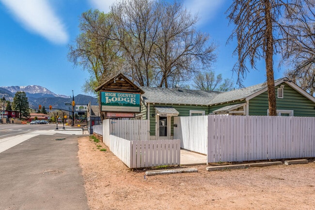
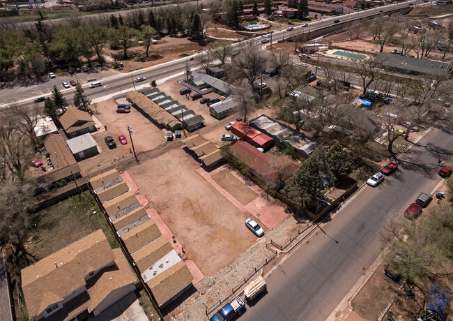
Property Record
3620 W Colorado Ave, Colorado Springs, CO 80904
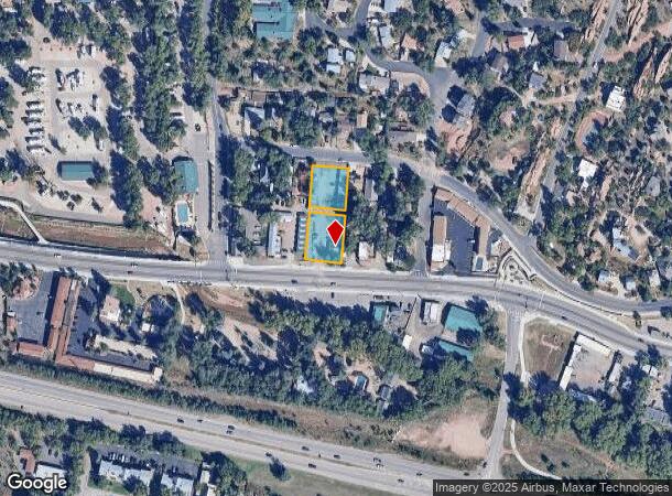
NEARBY LISTINGS FOR SALE OR LEASE
Property Detail
3620 W Colorado Ave
Colorado Springs, CO
Arensdale
74033-23-014
LOTS 5, 6, 15, 16 BLK 7 RESUB OF ARENSDALE COLO CITY
Multifamilydwelling
El Paso
AE
Colorado
08041C0707G
5
2024
0.58 AC
2025
Colorado Springs South/Airport
006701
Colorado Springs
3,781 SF
DEMOGRAPHICS near 3620 W Colorado Ave
1 Mile
3 Mile
5 Mile
2024 Total Population
5,200
38,946
106,572
2029 Population
5,429
40,767
111,278
Pop Growth 2024-2029
+ 4.40%
+ 4.68%
+ 4.42%
Average Age
47
45
42
2024 Total Households
2,499
18,438
49,427
HH Growth 2024-2029
+ 4.64%
+ 4.97%
+ 4.68%
Median Household Inc
$71,785
$71,063
$67,020
Avg Household Size
2.00
2.00
2.00
2024 Avg HH Vehicles
2.00
2.00
2.00
Median Home Value
$459,382
$463,859
$440,290
Median Year Built
1965
1975
1969
Nearby Places
- Restaurants
- Banks
- Shops
- Fitness
- Groceries
PUBLIC TRANSPORTATION
AIRPORT
City of Colorado Springs Municipal
DRIVE
WALK
Distance
City of Colorado Springs Municipal
27 min
14.5 mi
Freight Ports
Tulsa Port Of Catoosa
DRIVE
WALK
Distance
Tulsa Port Of Catoosa
749 min
698.3 mi
SALE & LEASE HISTORY
LISTING DATE
SALE/LEASE

Jun 07, 2020
For Sale
Nearby Properties
Address
Land Use
TOTAL SIZE
Lot Size
Zoning
Address
Land Use
TOTAL SIZE
Lot Size
Zoning
107,247 SF
56.98 AC
R-E PF
Address
Land Use
TOTAL SIZE
Lot Size
Zoning
662,208 SF
14.96 AC
BP
Address
Land Use
TOTAL SIZE
Lot Size
Zoning
198,916 SF
31.69 AC
PF/CR SS
Address
Land Use
TOTAL SIZE
Lot Size
Zoning
139,621 SF
403.34 AC
A R-E HS
Address
Land Use
TOTAL SIZE
Lot Size
Zoning
2,422 SF
616.19 AC
PK MX-I PD
Address
Land Use
TOTAL SIZE
Lot Size
Zoning
99,488 SF
13.01 AC
PDZ
Address
Land Use
TOTAL SIZE
Lot Size
Zoning
75,349 SF
27.75 AC
EPC
Address
Land Use
TOTAL SIZE
Lot Size
Zoning
41,015 SF
0.62 AC
BP
Address
Land Use
TOTAL SIZE
Lot Size
Zoning
24,420 SF
2.79 AC
PK
Address
Land Use
TOTAL SIZE
Lot Size
Zoning
45,268 SF
8.37 AC
PDZ UV
Address
Land Use
TOTAL SIZE
Lot Size
Zoning
37,196 SF
3 AC
PDZ
Address
Land Use
TOTAL SIZE
Lot Size
Zoning
99,085 SF
6.85 AC
R-1 6
Address
Land Use
TOTAL SIZE
Lot Size
Zoning
331,438 SF
14.63 AC
PDZ
Address
Land Use
TOTAL SIZE
Lot Size
Zoning
45,716 SF
Address
Land Use
TOTAL SIZE
Lot Size
Zoning
282,722 SF
11.15 AC
PDZ HS SS
Address
Land Use
TOTAL SIZE
Lot Size
Zoning
296,778 SF
14.67 AC
MX-M HS CU
Address
Land Use
TOTAL SIZE
Lot Size
Zoning
509,867 SF
21.96 AC
BP
Address
Land Use
TOTAL SIZE
Lot Size
Zoning
184,424 SF
15.83 AC
BP
Address
Land Use
TOTAL SIZE
Lot Size
Zoning
34,126 SF
1.37 AC
Address
Land Use
TOTAL SIZE
Lot Size
Zoning
129,525 SF
9 AC
PDZ SS
Address
Land Use
TOTAL SIZE
Lot Size
Zoning
212,439 SF
12.67 AC
R-5 UV
Address
Land Use
TOTAL SIZE
Lot Size
Zoning
1,017 SF
77 AC
PK HS SS
Address
Land Use
TOTAL SIZE
Lot Size
Zoning
100,020 SF
3.87 AC
C6 C6/CR
Address
Land Use
TOTAL SIZE
Lot Size
Zoning
254,039 SF
13.47 AC
R-5 CU
Address
Land Use
TOTAL SIZE
Lot Size
Zoning
30,324 SF
9.42 AC
R-2
Address
Land Use
TOTAL SIZE
Lot Size
Zoning
6,493 SF
97.13 AC
PF PK SS
Address
Land Use
TOTAL SIZE
Lot Size
Zoning
267,790 SF
15.13 AC
PDZ HS
Address
Land Use
TOTAL SIZE
Lot Size
Zoning
115,608 SF
9.45 AC
MX-M
Address
Land Use
TOTAL SIZE
Lot Size
Zoning
1,050 SF
28.55 AC
PUD
Address
Land Use
TOTAL SIZE
Lot Size
Zoning
157,471 SF
0.02 AC
PUD,HS
The World's #1 Commercial Real Estate Marketplace
Connect with us
© 2025 CoStar Group
The information above has been obtained from sources believed reliable. While we do not doubt its accuracy we have not verified it and make no guarantee, warranty or representation about it. It is your responsibility to independently confirm its accuracy and completeness. Any projections, opinions, assumptions, or estimates used are for example only and do not represent the current or future performance of the property. The value of this transaction to you depends on tax and other factors which should be evaluated by your tax, financial, and legal advisors. You and your advisors should conduct a careful, independent investigation of the property to determine to your satisfaction the suitability of the property for your needs.