Property Record
3620 Wetumpka Hwy, Montgomery, AL 36110
NEARBY LISTINGS FOR SALE OR LEASE
-
-
View all Montgomery listings for sale on LoopNet.com
Property Detail
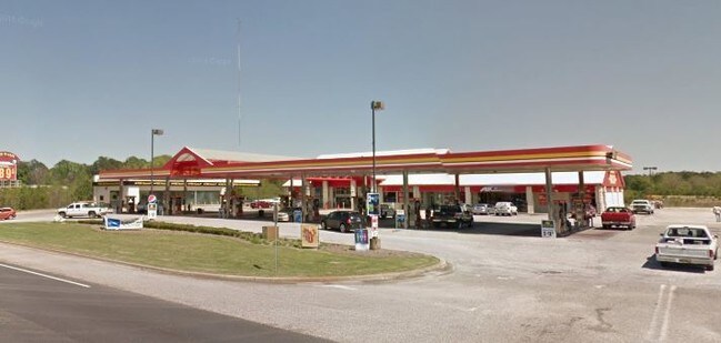
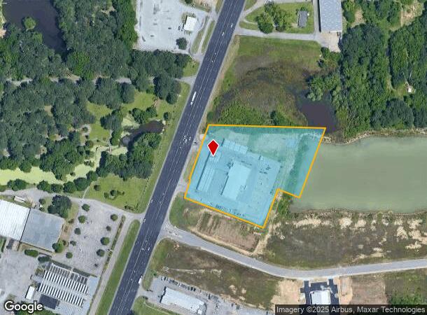
3620 Wetumpka Hwy
Montgomery, AL
Entec Stations 2
04-06-24-1-000-003.008
0406241000003008
Conveniencestore
Montgomery
AE
Alabama
01101C0104J
a
2025
4.86 AC
2025
North Montgomery
005101
Montgomery
11,297 SF
DEMOGRAPHICS near 3620 Wetumpka Hwy
1 Mile
3 Mile
5 Mile
2024 Total Population
564
4,260
41,009
2029 Population
566
4,226
40,090
Pop Growth 2024-2029
+ 0.35%
(0.80%)
(2.24%)
Average Age
45
41
39
2024 Total Households
202
1,615
16,740
HH Growth 2024-2029
+ 0.50%
(0.80%)
(2.32%)
Median Household Inc
$47,916
$62,250
$54,503
Avg Household Size
2.10
2.40
2.40
2024 Avg HH Vehicles
2.00
2.00
2.00
Median Home Value
$87,499
$164,640
$139,276
Median Year Built
1977
1992
1978
Nearby Places
- Restaurants
- Banks
- Shops
- Fitness
- Groceries
PUBLIC TRANSPORTATION
AIRPORT
Montgomery Regional (Dannelly Field)
DRIVE
WALK
Distance
Montgomery Regional (Dannelly Field)
23 min
17.9 mi
Freight Ports
Port of Panama City
DRIVE
WALK
Distance
Port of Panama City
242 min
191.6 mi
Nearby Properties
Address
Land Use
TOTAL SIZE
Lot Size
Zoning
Address
Land Use
TOTAL SIZE
Lot Size
Zoning
591,904 SF
26 AC
M-1
Address
Land Use
TOTAL SIZE
Lot Size
Zoning
67,643 SF
12.82 AC
M-1
Address
Land Use
TOTAL SIZE
Lot Size
Zoning
244,062 SF
12.94 AC
M-1
Address
Land Use
TOTAL SIZE
Lot Size
Zoning
48,672 SF
31 AC
Address
Land Use
TOTAL SIZE
Lot Size
Zoning
127,232 SF
9.61 AC
M-1
Address
Land Use
TOTAL SIZE
Lot Size
Zoning
292,718 SF
31 AC
M-1
Address
Land Use
TOTAL SIZE
Lot Size
Zoning
38,998 SF
10.43 AC
AGR-2
Address
Land Use
TOTAL SIZE
Lot Size
Zoning
76,213 SF
15 AC
Address
Land Use
TOTAL SIZE
Lot Size
Zoning
79,200 SF
8.40 AC
M-1
Address
Land Use
TOTAL SIZE
Lot Size
Zoning
52,302 SF
10.41 AC
B-2
Address
Land Use
TOTAL SIZE
Lot Size
Zoning
10,232 SF
18.48 AC
M-1
Address
Land Use
TOTAL SIZE
Lot Size
Zoning
8,170 SF
12.33 AC
M-1
Address
Land Use
TOTAL SIZE
Lot Size
Zoning
72,167 SF
5.12 AC
M-1
Address
Land Use
TOTAL SIZE
Lot Size
Zoning
87,384 SF
7.50 AC
M-1
Address
Land Use
TOTAL SIZE
Lot Size
Zoning
125,646 SF
9.57 AC
M-3
Address
Land Use
TOTAL SIZE
Lot Size
Zoning
51,575 SF
6.05 AC
M-1
Address
Land Use
TOTAL SIZE
Lot Size
Zoning
3,059 SF
115.30 AC
INST
Address
Land Use
TOTAL SIZE
Lot Size
Zoning
5,764 SF
2.52 AC
M-1
Address
Land Use
TOTAL SIZE
Lot Size
Zoning
17,729 SF
4.89 AC
M-1
Address
Land Use
TOTAL SIZE
Lot Size
Zoning
27,436 SF
19 AC
AGR-2
Address
Land Use
TOTAL SIZE
Lot Size
Zoning
32,600 SF
1.80 AC
B-2
Address
Land Use
TOTAL SIZE
Lot Size
Zoning
29,266 SF
15 AC
INST
Address
Land Use
TOTAL SIZE
Lot Size
Zoning
81,151 SF
12 AC
M-1
Address
Land Use
TOTAL SIZE
Lot Size
Zoning
4,752 SF
16.49 AC
Address
Land Use
TOTAL SIZE
Lot Size
Zoning
24,895 SF
2.09 AC
M-1
Address
Land Use
TOTAL SIZE
Lot Size
Zoning
21,587 SF
16.91 AC
M-3
Address
Land Use
TOTAL SIZE
Lot Size
Zoning
22,491 SF
9.92 AC
B-5
Address
Land Use
TOTAL SIZE
Lot Size
Zoning
26,642 SF
5.10 AC
B-2
Address
Land Use
TOTAL SIZE
Lot Size
Zoning
46,677 SF
M-1
The World's #1 Commercial Real Estate Marketplace
Connect with us
© 2025 CoStar Group
The information above has been obtained from sources believed reliable. While we do not doubt its accuracy we have not verified it and make no guarantee, warranty or representation about it. It is your responsibility to independently confirm its accuracy and completeness. Any projections, opinions, assumptions, or estimates used are for example only and do not represent the current or future performance of the property. The value of this transaction to you depends on tax and other factors which should be evaluated by your tax, financial, and legal advisors. You and your advisors should conduct a careful, independent investigation of the property to determine to your satisfaction the suitability of the property for your needs.