Property Record
3621 Ne Akin Dr, Lees Summit, MO 64064

NEARBY LISTINGS FOR SALE OR LEASE
Property Detail
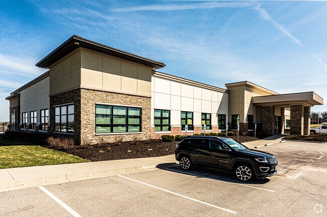
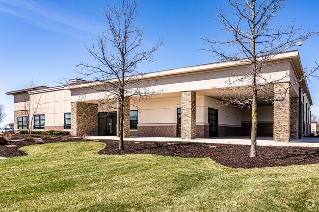
3621 Ne Akin Dr
Kansas City, MO-KS
Chapel Ridge Business Park
43-810-04-07-00-0-00-000
CHAPEL RIDGE BUSINESS PARK LOTS 15B & 15C---LOT 15B
Officebuilding
Jackson
X
Missouri
29095C0430G
15
2024
4.99 AC
2025
Raytown/Lakewood
014205
Kansas City
26,951 SF
DEMOGRAPHICS near 3621 Ne Akin Dr
1 Mile
3 Mile
5 Mile
2024 Total Population
4,673
20,347
103,832
2029 Population
4,645
20,143
102,962
Pop Growth 2024-2029
(0.60%)
(1.00%)
(0.84%)
Average Age
42
41
41
2024 Total Households
1,832
7,416
41,917
HH Growth 2024-2029
(0.60%)
(1.12%)
(0.85%)
Median Household Inc
$86,019
$112,612
$83,772
Avg Household Size
2.40
2.60
2.40
2024 Avg HH Vehicles
2.00
2.00
2.00
Median Home Value
$327,387
$327,267
$245,848
Median Year Built
1990
1993
1985
Nearby Places
Map Layers
Map Styles
 Street
 Aerial
- Restaurants
- Banks
- Shops
- Fitness
- Groceries
PUBLIC TRANSPORTATION
COMMUTER RAIL
Lee's Summit Amtrak (Lincoln Service Missouri River Runner - Amtrak, Missouri River Runner - Amtrak)
DRIVE
WALK
Distance
Lee's Summit Amtrak (Lincoln Service Missouri River Runner - Amtrak, Missouri River Runner - Amtrak)
11 min
5.7 mi
AIRPORT
Kansas City International
DRIVE
WALK
Distance
Kansas City International
52 min
38.9 mi
Freight Ports
Tulsa Port Of Catoosa
DRIVE
WALK
Distance
Tulsa Port Of Catoosa
270 min
242.9 mi
Nearby Properties
Address
Land Use
TOTAL SIZE
Lot Size
Zoning
Address
Land Use
TOTAL SIZE
Lot Size
Zoning
474,121 SF
40.14 AC
Address
Land Use
TOTAL SIZE
Lot Size
Zoning
195,589 SF
47.72 AC
Address
Land Use
TOTAL SIZE
Lot Size
Zoning
523,783 SF
1.61 AC
Address
Land Use
TOTAL SIZE
Lot Size
Zoning
140,377 SF
27 AC
Address
Land Use
TOTAL SIZE
Lot Size
Zoning
96,980 SF
66.45 AC
Address
Land Use
TOTAL SIZE
Lot Size
Zoning
108,530 SF
17.95 AC
Address
Land Use
TOTAL SIZE
Lot Size
Zoning
128,393 SF
27.30 AC
Address
Land Use
TOTAL SIZE
Lot Size
Zoning
75,028 SF
16.11 AC
Address
Land Use
TOTAL SIZE
Lot Size
Zoning
251,085 SF
Address
Land Use
TOTAL SIZE
Lot Size
Zoning
67,820 SF
11.94 AC
Address
Land Use
TOTAL SIZE
Lot Size
Zoning
Address
Land Use
TOTAL SIZE
Lot Size
Zoning
12,788 SF
16.29 AC
Address
Land Use
TOTAL SIZE
Lot Size
Zoning
94,314 SF
20.02 AC
Address
Land Use
TOTAL SIZE
Lot Size
Zoning
22,500 SF
Address
Land Use
TOTAL SIZE
Lot Size
Zoning
33,136 SF
3.99 AC
Address
Land Use
TOTAL SIZE
Lot Size
Zoning
67,800 SF
2.53 AC
Address
Land Use
TOTAL SIZE
Lot Size
Zoning
87,599 SF
9.19 AC
Address
Land Use
TOTAL SIZE
Lot Size
Zoning
15,585 SF
5.39 AC
Address
Land Use
TOTAL SIZE
Lot Size
Zoning
64,245 SF
10.05 AC
Address
Land Use
TOTAL SIZE
Lot Size
Zoning
69,312 SF
2.50 AC
Address
Land Use
TOTAL SIZE
Lot Size
Zoning
33,894 SF
3 AC
Address
Land Use
TOTAL SIZE
Lot Size
Zoning
13,573 SF
13.28 AC
Address
Land Use
TOTAL SIZE
Lot Size
Zoning
21,561 SF
4.37 AC
Address
Land Use
TOTAL SIZE
Lot Size
Zoning
36,627 SF
2.50 AC
Address
Land Use
TOTAL SIZE
Lot Size
Zoning
32,142 SF
10.77 AC
Address
Land Use
TOTAL SIZE
Lot Size
Zoning
33,994 SF
9.72 AC
Address
Land Use
TOTAL SIZE
Lot Size
Zoning
90,842 SF
11.54 AC
Address
Land Use
TOTAL SIZE
Lot Size
Zoning
200,850 SF
21.24 AC
Address
Land Use
TOTAL SIZE
Lot Size
Zoning
200,000 SF
14.44 AC
Address
Land Use
TOTAL SIZE
Lot Size
Zoning
11,294 SF
296.98 AC
The World's #1 Commercial Real Estate Marketplace
Connect with us
© 2026 CoStar Group
The information above has been obtained from sources believed reliable. While we do not doubt its accuracy we have not verified it and make no guarantee, warranty or representation about it. It is your responsibility to independently confirm its accuracy and completeness. Any projections, opinions, assumptions, or estimates used are for example only and do not represent the current or future performance of the property. The value of this transaction to you depends on tax and other factors which should be evaluated by your tax, financial, and legal advisors. You and your advisors should conduct a careful, independent investigation of the property to determine to your satisfaction the suitability of the property for your needs.