Property Record
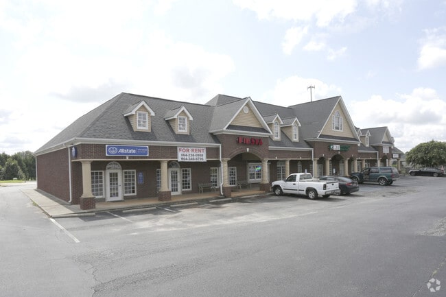
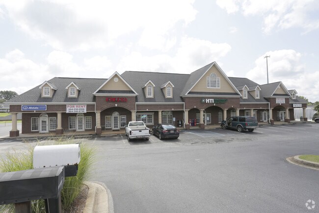
3622 Highway 81 N, Anderson, SC 29621

Property Detail
3622 Highway 81 N
Greenville-Anderson-Greer, SC
CP 000/000 PP S 1448/3A F000 D000 PP S 1232/3A TR A2B2 + STRIP HWY 81N 1.65AC
145-00-06-013
Anderson
Commercialnec
South Carolina
B and X Area of moderate flood hazard, usually the area between the limits of the 100-year and 500-year floods.
1.65 AC
2025
Highway 81
2025
Greenville/Spartanburg
011204
NEARBY LISTINGS FOR SALE OR LEASE
-
-
View all Anderson listings for lease on LoopNet.com
DEMOGRAPHICS near 3622 Highway 81 N
1 mile
3 mile
5 mile
2025 Total Population
1,958
10,802
36,182
2030 Population
2,062
11,347
37,965
Pop Growth 2025-2030
+ 5.31%
+ 5.05%
+ 4.93%
Average Age
43
42
42
2025 Total Households
718
3,943
14,117
HH Growth 2025-2030
+ 5.57%
+ 5.33%
+ 5.06%
Median Household Inc
$107,887
$101,946
$80,167
Avg Household Size
2.70
2.70
2.50
2025 Avg HH Vehicles
2.00
2.00
2.00
Median Home Value
$424,117
$391,461
$337,088
Median Year Built
2003
2001
1994
Nearby Places
Map Layers
Map Styles
 Street
 Aerial
Layers
 Traffic
 Biking
Places
Listings with unknown addresses are not visible on the map
- Restaurants
- Banks
- Shops
- Fitness
- Groceries
PUBLIC TRANSPORTATION
AIRPORT
Greenville Spartanburg International
Drive
Walk
Distance
Greenville Spartanburg International
45 min
33.9 mi
SALE & LEASE HISTORY
LISTING DATE
SALE/LEASE

Sep 25, 2016
For Lease
Nearby Properties
Address
Land Use
TOTAL SIZE
Lot Size
Zoning
Address
Land Use
TOTAL SIZE
Lot Size
Zoning
41.61 AC
Address
Land Use
TOTAL SIZE
Lot Size
Zoning
86.84 AC
Address
Land Use
TOTAL SIZE
Lot Size
Zoning
59.13 AC
Address
Land Use
TOTAL SIZE
Lot Size
Zoning
2,420 SF
48.50 AC
Address
Land Use
TOTAL SIZE
Lot Size
Zoning
29.70 AC
Address
Land Use
TOTAL SIZE
Lot Size
Zoning
66,400 SF
12 AC
Address
Land Use
TOTAL SIZE
Lot Size
Zoning
6.12 AC
Address
Land Use
TOTAL SIZE
Lot Size
Zoning
91,455 SF
12 AC
Address
Land Use
TOTAL SIZE
Lot Size
Zoning
67,563 SF
17.23 AC
Address
Land Use
TOTAL SIZE
Lot Size
Zoning
31,616 SF
4.99 AC
Address
Land Use
TOTAL SIZE
Lot Size
Zoning
4.63 AC
Address
Land Use
TOTAL SIZE
Lot Size
Zoning
2,408 SF
3.89 AC
Address
Land Use
TOTAL SIZE
Lot Size
Zoning
46,659 SF
2 AC
Address
Land Use
TOTAL SIZE
Lot Size
Zoning
45,085 SF
6.96 AC
Address
Land Use
TOTAL SIZE
Lot Size
Zoning
1,768 SF
7.33 AC
Address
Land Use
TOTAL SIZE
Lot Size
Zoning
30,736 SF
3.05 AC
Address
Land Use
TOTAL SIZE
Lot Size
Zoning
5,248 SF
9.44 AC
Address
Land Use
TOTAL SIZE
Lot Size
Zoning
34,568 SF
1.85 AC
Address
Land Use
TOTAL SIZE
Lot Size
Zoning
3,835 SF
2.98 AC
Address
Land Use
TOTAL SIZE
Lot Size
Zoning
41.95 AC
Address
Land Use
TOTAL SIZE
Lot Size
Zoning
15,435 SF
2.94 AC
Address
Land Use
TOTAL SIZE
Lot Size
Zoning
7,507 SF
7.73 AC
Address
Land Use
TOTAL SIZE
Lot Size
Zoning
12.86 AC
Address
Land Use
TOTAL SIZE
Lot Size
Zoning
8,242 SF
1.22 AC
Address
Land Use
TOTAL SIZE
Lot Size
Zoning
4,030 SF
0.72 AC
Address
Land Use
TOTAL SIZE
Lot Size
Zoning
14,316 SF
6.03 AC
Address
Land Use
TOTAL SIZE
Lot Size
Zoning
2,236 SF
33.80 AC
Address
Land Use
TOTAL SIZE
Lot Size
Zoning
29,000 SF
10.92 AC
The World's #1 Commercial Real Estate Marketplace
Connect with us
© 2026 CoStar Group
The information above has been obtained from sources believed reliable. While we do not doubt its accuracy we have not verified it and make no guarantee, warranty or representation about it. It is your responsibility to independently confirm its accuracy and completeness. Any projections, opinions, assumptions, or estimates used are for example only and do not represent the current or future performance of the property. The value of this transaction to you depends on tax and other factors which should be evaluated by your tax, financial, and legal advisors. You and your advisors should conduct a careful, independent investigation of the property to determine to your satisfaction the suitability of the property for your needs.