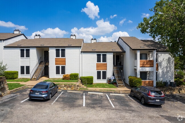
Property Record
3622 Menchaca Rd, Austin, TX 78704

Property Detail
3622 Menchaca Rd
Austin-Round Rock-San Marcos, TX
LOT A WADE-BUELL ADDN
306014
Travis
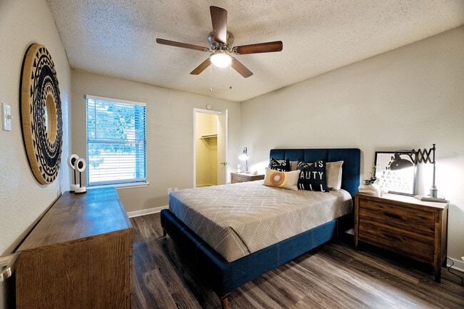
Multifamilydwelling
Texas
B and X Area of moderate flood hazard, usually the area between the limits of the 100-year and 500-year floods.
a
2025
3.86 AC
2025
South Lamar
002004
Austin
85,980 SF
NEARBY LISTINGS FOR SALE OR LEASE
DEMOGRAPHICS near 3622 Menchaca Rd
1 mile
3 mile
5 mile
2024 Total Population
17,737
125,545
362,083
2029 Population
18,592
131,655
379,372
Pop Growth 2024-2029
+ 4.82%
+ 4.87%
+ 4.77%
Average Age
37
39
36
2024 Total Households
9,767
63,693
163,522
HH Growth 2024-2029
+ 5.44%
+ 5.53%
+ 5.65%
Median Household Inc
$86,823
$104,185
$90,306
Avg Household Size
1.80
1.90
2.00
2024 Avg HH Vehicles
1.00
2.00
2.00
Median Home Value
$796,760
$791,319
$707,502
Median Year Built
1988
1992
1995
Nearby Places
Map Layers
Map Styles
 Street
 Aerial
Transit
 Traffic
 Biking
Places
Listings with unknown addresses are not visible on the map
- Restaurants
- Banks
- Shops
- Fitness
- Groceries
PUBLIC TRANSPORTATION
COMMUTER RAIL
Austin (Texas Eagle - Amtrak)
Drive
Walk
Distance
Austin (Texas Eagle - Amtrak)
9 min
3.4 mi
AIRPORT
Austin-Bergstrom International
Drive
Walk
Distance
Austin-Bergstrom International
23 min
11.2 mi
Freight Ports
Calhoun Port
Drive
Walk
Distance
Calhoun Port
189 min
154.6 mi
Nearby Properties
Address
Land Use
TOTAL SIZE
Lot Size
Zoning
Address
Land Use
TOTAL SIZE
Lot Size
Zoning
262 SF
65.06 AC
Address
Land Use
TOTAL SIZE
Lot Size
Zoning
786,600 SF
1.27 AC
Address
Land Use
TOTAL SIZE
Lot Size
Zoning
498,684 SF
61.86 AC
Address
Land Use
TOTAL SIZE
Lot Size
Zoning
47.20 AC
Address
Land Use
TOTAL SIZE
Lot Size
Zoning
35,041 SF
28.65 AC
Address
Land Use
TOTAL SIZE
Lot Size
Zoning
513,567 SF
1.78 AC
Address
Land Use
TOTAL SIZE
Lot Size
Zoning
500,511 SF
0.82 AC
Address
Land Use
TOTAL SIZE
Lot Size
Zoning
24.06 AC
Address
Land Use
TOTAL SIZE
Lot Size
Zoning
341,096 SF
0.31 AC
Address
Land Use
TOTAL SIZE
Lot Size
Zoning
337,855 SF
43.51 AC
Address
Land Use
TOTAL SIZE
Lot Size
Zoning
Address
Land Use
TOTAL SIZE
Lot Size
Zoning
6.12 AC
Address
Land Use
TOTAL SIZE
Lot Size
Zoning
27.45 AC
Address
Land Use
TOTAL SIZE
Lot Size
Zoning
627,984 SF
0.81 AC
Address
Land Use
TOTAL SIZE
Lot Size
Zoning
219,543 SF
0.22 AC
Address
Land Use
TOTAL SIZE
Lot Size
Zoning
652,852 SF
1.01 AC
Address
Land Use
TOTAL SIZE
Lot Size
Zoning
8,213 SF
36.95 AC
Address
Land Use
TOTAL SIZE
Lot Size
Zoning
101.08 AC
Address
Land Use
TOTAL SIZE
Lot Size
Zoning
442,023 SF
8.97 AC
Address
Land Use
TOTAL SIZE
Lot Size
Zoning
372,000 SF
1.35 AC
Address
Land Use
TOTAL SIZE
Lot Size
Zoning
8.17 AC
Address
Land Use
TOTAL SIZE
Lot Size
Zoning
368,349 SF
17.13 AC
Address
Land Use
TOTAL SIZE
Lot Size
Zoning
250,514 SF
1.80 AC
Address
Land Use
TOTAL SIZE
Lot Size
Zoning
13.46 AC
Address
Land Use
TOTAL SIZE
Lot Size
Zoning
456,650 SF
15 AC
Address
Land Use
TOTAL SIZE
Lot Size
Zoning
551,881 SF
34.85 AC
Address
Land Use
TOTAL SIZE
Lot Size
Zoning
224,624 SF
4.61 AC
Address
Land Use
TOTAL SIZE
Lot Size
Zoning
269,203 SF
1.46 AC
Address
Land Use
TOTAL SIZE
Lot Size
Zoning
115,000 SF
1.73 AC
Address
Land Use
TOTAL SIZE
Lot Size
Zoning
300,530 SF
3.62 AC
The World's #1 Commercial Real Estate Marketplace
Connect with us
© 2026 CoStar Group
The information above has been obtained from sources believed reliable. While we do not doubt its accuracy we have not verified it and make no guarantee, warranty or representation about it. It is your responsibility to independently confirm its accuracy and completeness. Any projections, opinions, assumptions, or estimates used are for example only and do not represent the current or future performance of the property. The value of this transaction to you depends on tax and other factors which should be evaluated by your tax, financial, and legal advisors. You and your advisors should conduct a careful, independent investigation of the property to determine to your satisfaction the suitability of the property for your needs.