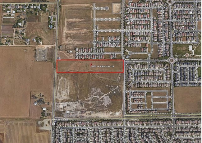
Property Record
3622 N State Highway 59, Merced, CA 95348


NEARBY LISTINGS FOR SALE OR LEASE
Property Detail
3622 N State Highway 59
Merced, CA
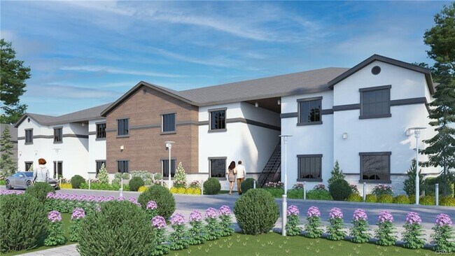
Sunrise At Compass Pointe
206-050-017
SUNRISE AT COMPASS POINTE LOT #123
Recreationalacreage
Merced
X
California
06047C0409G
123
2024
10.73 AC
2025
Suburban Merced
001008
Fresno
DEMOGRAPHICS near 3622 N State Highway 59
1 Mile
3 Mile
5 Mile
2024 Total Population
11,037
72,290
127,854
2029 Population
12,007
78,211
138,350
Pop Growth 2024-2029
+ 8.79%
+ 8.19%
+ 8.21%
Average Age
34
35
35
2024 Total Households
3,263
23,245
39,557
HH Growth 2024-2029
+ 8.70%
+ 8.31%
+ 8.33%
Median Household Inc
$91,779
$51,863
$52,363
Avg Household Size
3.20
2.90
3.10
2024 Avg HH Vehicles
2.00
2.00
2.00
Median Home Value
$356,823
$330,212
$338,167
Median Year Built
2000
1983
1984
Nearby Places
Map Layers
Map Styles
 Street
 Aerial
- Restaurants
- Banks
- Shops
- Fitness
- Groceries
PUBLIC TRANSPORTATION
COMMUTER RAIL
Merced (San Joaquins - Amtrak)
DRIVE
WALK
Distance
Merced (San Joaquins - Amtrak)
8 min
4.4 mi
Freight Ports
Port of Stockton
DRIVE
WALK
Distance
Port of Stockton
90 min
72.9 mi
SALE & LEASE HISTORY
LISTING DATE
SALE/LEASE

May 30, 2024
For Sale
Jan 18, 2019
For Sale
Feb 12, 2025
For Sale
Aug 28, 2023
For Sale
Apr 12, 2018
For Sale
Nearby Properties
Address
Land Use
TOTAL SIZE
Lot Size
Zoning
Address
Land Use
TOTAL SIZE
Lot Size
Zoning
17.50 AC
CO
Address
Land Use
TOTAL SIZE
Lot Size
Zoning
7.80 AC
IL
Address
Land Use
TOTAL SIZE
Lot Size
Zoning
12.35 AC
CG
Address
Land Use
TOTAL SIZE
Lot Size
Zoning
4.87 AC
PD
Address
Land Use
TOTAL SIZE
Lot Size
Zoning
2.90 AC
CO
Address
Land Use
TOTAL SIZE
Lot Size
Zoning
27.48 AC
PD
Address
Land Use
TOTAL SIZE
Lot Size
Zoning
3.50 AC
R4
Address
Land Use
TOTAL SIZE
Lot Size
Zoning
42.55 AC
Address
Land Use
TOTAL SIZE
Lot Size
Zoning
10.10 AC
PD
Address
Land Use
TOTAL SIZE
Lot Size
Zoning
18.40 AC
IL
Address
Land Use
TOTAL SIZE
Lot Size
Zoning
28.36 AC
Address
Land Use
TOTAL SIZE
Lot Size
Zoning
15,189 SF
1.70 AC
CO
Address
Land Use
TOTAL SIZE
Lot Size
Zoning
3.90 AC
PD
Address
Land Use
TOTAL SIZE
Lot Size
Zoning
4.50 AC
R4
Address
Land Use
TOTAL SIZE
Lot Size
Zoning
2 AC
PD
Address
Land Use
TOTAL SIZE
Lot Size
Zoning
10.30 AC
CT
Address
Land Use
TOTAL SIZE
Lot Size
Zoning
11.80 AC
PD
Address
Land Use
TOTAL SIZE
Lot Size
Zoning
5.91 AC
PD
Address
Land Use
TOTAL SIZE
Lot Size
Zoning
0.48 AC
CC
Address
Land Use
TOTAL SIZE
Lot Size
Zoning
124,880 SF
10 AC
PD
Address
Land Use
TOTAL SIZE
Lot Size
Zoning
1.80 AC
Address
Land Use
TOTAL SIZE
Lot Size
Zoning
9,000 SF
9.30 AC
IH
Address
Land Use
TOTAL SIZE
Lot Size
Zoning
1.90 AC
CT
Address
Land Use
TOTAL SIZE
Lot Size
Zoning
6,296 SF
3.30 AC
Address
Land Use
TOTAL SIZE
Lot Size
Zoning
26,594 SF
0.36 AC
PD
Address
Land Use
TOTAL SIZE
Lot Size
Zoning
0.34 AC
CC
Address
Land Use
TOTAL SIZE
Lot Size
Zoning
6,738 SF
5.92 AC
RPD
Address
Land Use
TOTAL SIZE
Lot Size
Zoning
40 AC
IH
Address
Land Use
TOTAL SIZE
Lot Size
Zoning
5.90 AC
RPD
Address
Land Use
TOTAL SIZE
Lot Size
Zoning
3.66 AC
RPD
The World's #1 Commercial Real Estate Marketplace
Connect with us
© 2025 CoStar Group
The information above has been obtained from sources believed reliable. While we do not doubt its accuracy we have not verified it and make no guarantee, warranty or representation about it. It is your responsibility to independently confirm its accuracy and completeness. Any projections, opinions, assumptions, or estimates used are for example only and do not represent the current or future performance of the property. The value of this transaction to you depends on tax and other factors which should be evaluated by your tax, financial, and legal advisors. You and your advisors should conduct a careful, independent investigation of the property to determine to your satisfaction the suitability of the property for your needs.