Property Record
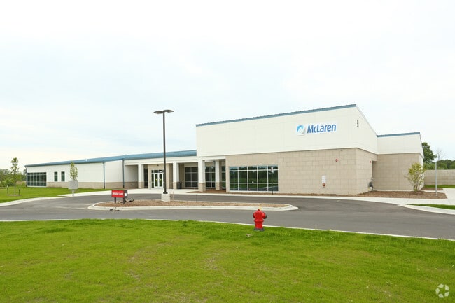
36267 26 Mile Rd, Lenox, MI 48048


NEARBY LISTINGS FOR SALE OR LEASE
Property Detail
36267 26 Mile Rd
19-06-36-300-026
SPLIT/COMBINED ON 11/25/2014 FROM 19-06-36-300-024; T4N, R14E, SEC 36; COMM AT S 1/4 POST SEC 36; TH N02*14'36W 1890.26 FT;
Medicalbuilding
Macomb
X
Michigan
26147C0476D
4.28 AC
2025
St Clair & Lapeer Counties
2025
Detroit
218001
Detroit-Warren-Dearborn, MI
15,788 SF
DEMOGRAPHICS near 36267 26 Mile Rd
1 Mile
3 Mile
5 Mile
2024 Total Population
1,574
24,199
56,305
2029 Population
1,575
24,185
56,245
Pop Growth 2024-2029
+ 0.06%
(0.06%)
(0.11%)
Average Age
42
39
40
2024 Total Households
354
7,991
20,889
HH Growth 2024-2029
+ 0.85%
(0.04%)
(0.05%)
Median Household Inc
$55,874
$79,544
$77,806
Avg Household Size
2.70
2.80
2.60
2024 Avg HH Vehicles
2.00
2.00
2.00
Median Home Value
$127,551
$236,727
$250,472
Median Year Built
2005
1999
1994
Nearby Places
Map Layers
Map Styles
 Street
 Aerial
- Restaurants
- Banks
- Shops
- Fitness
- Groceries
PUBLIC TRANSPORTATION
AIRPORT
Windsor International
DRIVE
WALK
Distance
Windsor International
69 min
45.5 mi
SALE & LEASE HISTORY
LISTING DATE
SALE/LEASE

Sep 24, 2016
For Lease
Nearby Properties
Address
Land Use
TOTAL SIZE
Lot Size
Zoning
Address
Land Use
TOTAL SIZE
Lot Size
Zoning
115,695 SF
Address
Land Use
TOTAL SIZE
Lot Size
Zoning
2,520 SF
712.24 AC
AG
Address
Land Use
TOTAL SIZE
Lot Size
Zoning
210,688 SF
20.13 AC
CG
Address
Land Use
TOTAL SIZE
Lot Size
Zoning
7,262 SF
127.87 AC
MH
Address
Land Use
TOTAL SIZE
Lot Size
Zoning
276,497 SF
31.19 AC
I-1
Address
Land Use
TOTAL SIZE
Lot Size
Zoning
89,620 SF
17.89 AC
Address
Land Use
TOTAL SIZE
Lot Size
Zoning
60,123 SF
120 AC
I-2
Address
Land Use
TOTAL SIZE
Lot Size
Zoning
3,799 SF
56.46 AC
MH
Address
Land Use
TOTAL SIZE
Lot Size
Zoning
176,142 SF
21.95 AC
IND
Address
Land Use
TOTAL SIZE
Lot Size
Zoning
26,578 SF
31.52 AC
IR
Address
Land Use
TOTAL SIZE
Lot Size
Zoning
49,600 SF
14.50 AC
I-2
Address
Land Use
TOTAL SIZE
Lot Size
Zoning
88,116 SF
5.66 AC
IO
Address
Land Use
TOTAL SIZE
Lot Size
Zoning
10,297 SF
1.91 AC
AG
Address
Land Use
TOTAL SIZE
Lot Size
Zoning
30,878 SF
5.32 AC
IO
Address
Land Use
TOTAL SIZE
Lot Size
Zoning
85,097 SF
4.87 AC
M2 GEN
Address
Land Use
TOTAL SIZE
Lot Size
Zoning
21,944 SF
131.37 AC
CG
Address
Land Use
TOTAL SIZE
Lot Size
Zoning
18,905 SF
6.40 AC
RO
Address
Land Use
TOTAL SIZE
Lot Size
Zoning
3,418 SF
60 AC
CG
Address
Land Use
TOTAL SIZE
Lot Size
Zoning
3,927 SF
85.22 AC
MF
Address
Land Use
TOTAL SIZE
Lot Size
Zoning
26,578 SF
22.50 AC
Address
Land Use
TOTAL SIZE
Lot Size
Zoning
7.93 AC
I-1
Address
Land Use
TOTAL SIZE
Lot Size
Zoning
80,600 SF
6.52 AC
I-2
Address
Land Use
TOTAL SIZE
Lot Size
Zoning
17,880 SF
4.78 AC
I
Address
Land Use
TOTAL SIZE
Lot Size
Zoning
20,434 SF
2.89 AC
SF II
Address
Land Use
TOTAL SIZE
Lot Size
Zoning
56,505 SF
I-1
Address
Land Use
TOTAL SIZE
Lot Size
Zoning
68,000 SF
10.54 AC
CC
Address
Land Use
TOTAL SIZE
Lot Size
Zoning
5,682 SF
47.12 AC
RT
Address
Land Use
TOTAL SIZE
Lot Size
Zoning
13,145 SF
4.05 AC
GB
Address
Land Use
TOTAL SIZE
Lot Size
Zoning
45 AC
RT
The World's #1 Commercial Real Estate Marketplace
Connect with us
© 2025 CoStar Group
The information above has been obtained from sources believed reliable. While we do not doubt its accuracy we have not verified it and make no guarantee, warranty or representation about it. It is your responsibility to independently confirm its accuracy and completeness. Any projections, opinions, assumptions, or estimates used are for example only and do not represent the current or future performance of the property. The value of this transaction to you depends on tax and other factors which should be evaluated by your tax, financial, and legal advisors. You and your advisors should conduct a careful, independent investigation of the property to determine to your satisfaction the suitability of the property for your needs.