Property Record
3629 Chico Way Nw, Bremerton, WA 98312
NEARBY LISTINGS FOR SALE OR LEASE
Property Detail
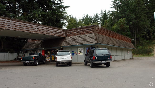
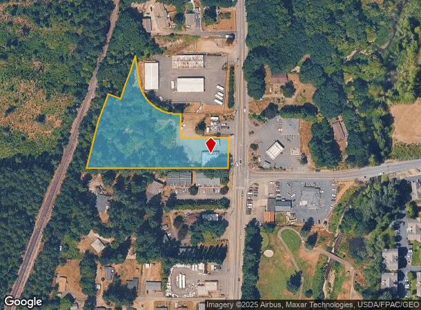
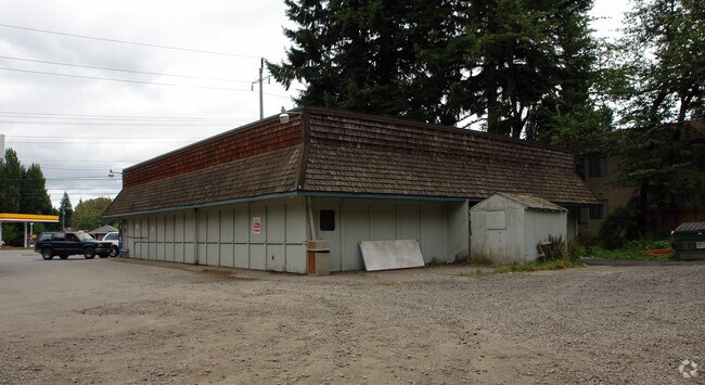
3629 Chico Way Nw
052401-3-028-2004
RESULTANT PARCEL 1 OF BOUNDARY LINE ADJUSTMENT AGREEMENT RECORDED UNDER AUDITORS FILE NO. 201908210056, AND AS DEPICTED ON SURVEY RECORDED UNDER AUDITORS FILE NO. 201910170191, IN VOLUME 89 OF SURVEYS, PAGE 241, RECORDS OF KITSAP COUNTY, WASHINGTON,
Servicestation
Kitsap
X
Washington
53035C0352F
2.53 AC
2025
West Kitsap County
2026
Bremerton/Silverdale
091400
Bremerton-Silverdale, WA
3,339 SF
DEMOGRAPHICS near 3629 Chico Way Nw
1 Mile
3 Mile
5 Mile
2024 Total Population
4,275
24,724
98,086
2029 Population
4,291
25,143
99,529
Pop Growth 2024-2029
+ 0.37%
+ 1.69%
+ 1.47%
Average Age
37
41
39
2024 Total Households
1,624
9,703
37,959
HH Growth 2024-2029
+ 0.37%
+ 1.88%
+ 1.65%
Median Household Inc
$75,883
$72,999
$71,135
Avg Household Size
2.60
2.50
2.40
2024 Avg HH Vehicles
2.00
2.00
2.00
Median Home Value
$466,894
$476,880
$405,953
Median Year Built
1978
1981
1980
Nearby Places
Map Layers
Map Styles
 Street
 Aerial
- Restaurants
- Banks
- Shops
- Fitness
- Groceries
PUBLIC TRANSPORTATION
AIRPORT
Seattle Paine Field International
DRIVE
WALK
Distance
Seattle Paine Field International
84 min
39.0 mi
Freight Ports
Port of Tacoma
DRIVE
WALK
Distance
Port of Tacoma
51 min
37.8 mi
Nearby Properties
Address
Land Use
TOTAL SIZE
Lot Size
Zoning
Address
Land Use
TOTAL SIZE
Lot Size
Zoning
21,408 SF
8.26 AC
BVSAP
Address
Land Use
TOTAL SIZE
Lot Size
Zoning
138,877 SF
7.17 AC
R-10
Address
Land Use
TOTAL SIZE
Lot Size
Zoning
66,022 SF
8.28 AC
RR
Address
Land Use
TOTAL SIZE
Lot Size
Zoning
68,079 SF
2.16 AC
BVSAP
Address
Land Use
TOTAL SIZE
Lot Size
Zoning
43,944 SF
2.64 AC
FC
Address
Land Use
TOTAL SIZE
Lot Size
Zoning
45,682 SF
2.04 AC
GC
Address
Land Use
TOTAL SIZE
Lot Size
Zoning
75,225 SF
3.30 AC
R-10
Address
Land Use
TOTAL SIZE
Lot Size
Zoning
48,520 SF
3.76 AC
GC
Address
Land Use
TOTAL SIZE
Lot Size
Zoning
52,461 SF
5.92 AC
RR
Address
Land Use
TOTAL SIZE
Lot Size
Zoning
42,665 SF
5.55 AC
FC
Address
Land Use
TOTAL SIZE
Lot Size
Zoning
52,601 SF
6.30 AC
BVSAP
Address
Land Use
TOTAL SIZE
Lot Size
Zoning
47,064 SF
5.27 AC
GC
Address
Land Use
TOTAL SIZE
Lot Size
Zoning
74,169 SF
2.62 AC
GC
Address
Land Use
TOTAL SIZE
Lot Size
Zoning
28,982 SF
1.90 AC
GC
Address
Land Use
TOTAL SIZE
Lot Size
Zoning
2.31 AC
CITY
Address
Land Use
TOTAL SIZE
Lot Size
Zoning
38,580 SF
2.44 AC
I
Address
Land Use
TOTAL SIZE
Lot Size
Zoning
42,400 SF
5.40 AC
FC
Address
Land Use
TOTAL SIZE
Lot Size
Zoning
28,000 SF
3.78 AC
FC
Address
Land Use
TOTAL SIZE
Lot Size
Zoning
7,767 SF
1 AC
UL
Address
Land Use
TOTAL SIZE
Lot Size
Zoning
33,354 SF
3.18 AC
GC
Address
Land Use
TOTAL SIZE
Lot Size
Zoning
32,717 SF
3.29 AC
GC
Address
Land Use
TOTAL SIZE
Lot Size
Zoning
26,386 SF
4.68 AC
FC
Address
Land Use
TOTAL SIZE
Lot Size
Zoning
49,200 SF
2.54 AC
GC
Address
Land Use
TOTAL SIZE
Lot Size
Zoning
49,036 SF
4.06 AC
I
Address
Land Use
TOTAL SIZE
Lot Size
Zoning
21,000 SF
0.76 AC
GC
Address
Land Use
TOTAL SIZE
Lot Size
Zoning
5,065 SF
1.18 AC
GC
Address
Land Use
TOTAL SIZE
Lot Size
Zoning
36,228 SF
8.41 AC
RR
Address
Land Use
TOTAL SIZE
Lot Size
Zoning
34,337 SF
2.62 AC
RR
Address
Land Use
TOTAL SIZE
Lot Size
Zoning
37,300 SF
1.28 AC
IND
Address
Land Use
TOTAL SIZE
Lot Size
Zoning
53,360 SF
2.44 AC
GC
The World's #1 Commercial Real Estate Marketplace
Connect with us
© 2025 CoStar Group
The information above has been obtained from sources believed reliable. While we do not doubt its accuracy we have not verified it and make no guarantee, warranty or representation about it. It is your responsibility to independently confirm its accuracy and completeness. Any projections, opinions, assumptions, or estimates used are for example only and do not represent the current or future performance of the property. The value of this transaction to you depends on tax and other factors which should be evaluated by your tax, financial, and legal advisors. You and your advisors should conduct a careful, independent investigation of the property to determine to your satisfaction the suitability of the property for your needs.