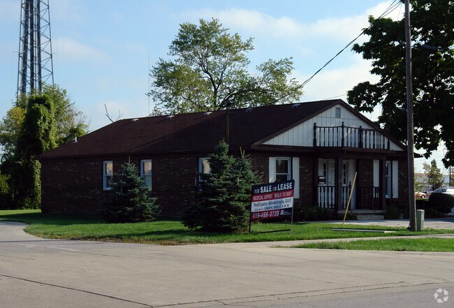
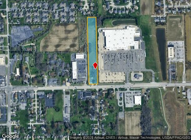
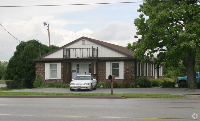
Property Record
3629 Navarre Ave, Oregon, OH 43616
NEARBY LISTINGS FOR SALE OR LEASE
Property Detail
3629 Navarre Ave
44-19621
8 10 3 SW 1/4 E 1/2 S 1/2 W 1/2 W 1/2 E 1/2 EXC S 377.42 FT& W IRREG PCE MEAS 4
Commercialacreage
Lucas
X
Ohio
39095C0115F
5.72 AC
0
East Toledo/Oregon
2025
Toledo
009901
Toledo, OH
4,230 SF
DEMOGRAPHICS near 3629 Navarre Ave
1 Mile
3 Mile
5 Mile
2024 Total Population
5,619
36,777
92,550
2029 Population
5,498
36,528
92,661
Pop Growth 2024-2029
(2.15%)
(0.68%)
+ 0.12%
Average Age
45
40
39
2024 Total Households
2,389
14,858
38,081
HH Growth 2024-2029
(2.26%)
(0.81%)
+ 0.01%
Median Household Inc
$70,069
$49,528
$38,791
Avg Household Size
2.20
2.30
2.30
2024 Avg HH Vehicles
2.00
2.00
1.00
Median Home Value
$185,598
$136,890
$110,856
Median Year Built
1974
1958
1955
Nearby Places
Map Layers
Map Styles
 Street
 Aerial
- Restaurants
- Banks
- Shops
- Fitness
- Groceries
PUBLIC TRANSPORTATION
COMMUTER RAIL
Toledo (Capitol Limited - Amtrak, Lake Shore Limited - Amtrak)
DRIVE
WALK
Distance
Toledo (Capitol Limited - Amtrak, Lake Shore Limited - Amtrak)
10 min
5.1 mi
AIRPORT
Eugene F Kranz Toledo Express
DRIVE
WALK
Distance
Eugene F Kranz Toledo Express
41 min
23.1 mi
Freight Ports
Port of Toledo
DRIVE
WALK
Distance
Port of Toledo
13 min
4.7 mi
Nearby Properties
Address
Land Use
TOTAL SIZE
Lot Size
Zoning
Address
Land Use
TOTAL SIZE
Lot Size
Zoning
605,609 SF
9.66 AC
40-C4
Address
Land Use
TOTAL SIZE
Lot Size
Zoning
311,537 SF
35.14 AC
40-R1
Address
Land Use
TOTAL SIZE
Lot Size
Zoning
313,004 SF
44.54 AC
40-C2
Address
Land Use
TOTAL SIZE
Lot Size
Zoning
225,407 SF
128.05 AC
10-MX
Address
Land Use
TOTAL SIZE
Lot Size
Zoning
136,090 SF
4 AC
Address
Land Use
TOTAL SIZE
Lot Size
Zoning
127,658 SF
9.01 AC
40-C4
Address
Land Use
TOTAL SIZE
Lot Size
Zoning
73,802 SF
22.50 AC
40-R1
Address
Land Use
TOTAL SIZE
Lot Size
Zoning
334,732 SF
516.10 AC
40-M2
Address
Land Use
TOTAL SIZE
Lot Size
Zoning
22.93 AC
40-R3
Address
Land Use
TOTAL SIZE
Lot Size
Zoning
214,312 SF
35.35 AC
40-C5
Address
Land Use
TOTAL SIZE
Lot Size
Zoning
27.41 AC
40-CI
Address
Land Use
TOTAL SIZE
Lot Size
Zoning
102,535 SF
20 AC
40-R2
Address
Land Use
TOTAL SIZE
Lot Size
Zoning
228,251 SF
43.08 AC
10-RD6
Address
Land Use
TOTAL SIZE
Lot Size
Zoning
73,731 SF
2 AC
10-RD6
Address
Land Use
TOTAL SIZE
Lot Size
Zoning
34 AC
40-C5
Address
Land Use
TOTAL SIZE
Lot Size
Zoning
230,074 SF
142.89 AC
40-M2
Address
Land Use
TOTAL SIZE
Lot Size
Zoning
150,000 SF
17.55 AC
40-CI
Address
Land Use
TOTAL SIZE
Lot Size
Zoning
181,347 SF
14.12 AC
40-R4
Address
Land Use
TOTAL SIZE
Lot Size
Zoning
187,988 SF
20 AC
40-M2
Address
Land Use
TOTAL SIZE
Lot Size
Zoning
61,289 SF
2 AC
10-RD6
Address
Land Use
TOTAL SIZE
Lot Size
Zoning
29.92 AC
40-CI
Address
Land Use
TOTAL SIZE
Lot Size
Zoning
62,546 SF
4.27 AC
10-RD6
Address
Land Use
TOTAL SIZE
Lot Size
Zoning
117,094 SF
28.04 AC
40-R2
Address
Land Use
TOTAL SIZE
Lot Size
Zoning
199,768 SF
16.15 AC
40-C2
Address
Land Use
TOTAL SIZE
Lot Size
Zoning
77,079 SF
3.87 AC
40-R3
Address
Land Use
TOTAL SIZE
Lot Size
Zoning
265,601 SF
11.34 AC
10-IG
Address
Land Use
TOTAL SIZE
Lot Size
Zoning
178,841 SF
19 AC
10-RM36
Address
Land Use
TOTAL SIZE
Lot Size
Zoning
55,544 SF
13 AC
40-R2
Address
Land Use
TOTAL SIZE
Lot Size
Zoning
91,261 SF
5.47 AC
40-C2
Address
Land Use
TOTAL SIZE
Lot Size
Zoning
106,525 SF
18.90 AC
The World's #1 Commercial Real Estate Marketplace
Connect with us
© 2026 CoStar Group
The information above has been obtained from sources believed reliable. While we do not doubt its accuracy we have not verified it and make no guarantee, warranty or representation about it. It is your responsibility to independently confirm its accuracy and completeness. Any projections, opinions, assumptions, or estimates used are for example only and do not represent the current or future performance of the property. The value of this transaction to you depends on tax and other factors which should be evaluated by your tax, financial, and legal advisors. You and your advisors should conduct a careful, independent investigation of the property to determine to your satisfaction the suitability of the property for your needs.