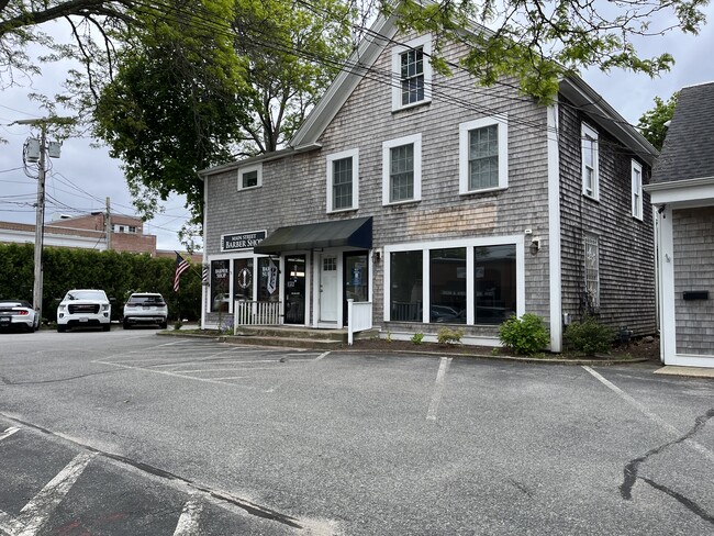
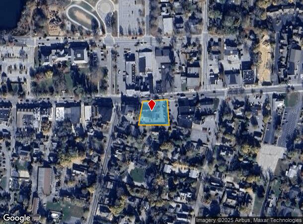
Property Record
363 Main St, Falmouth, MA 02540
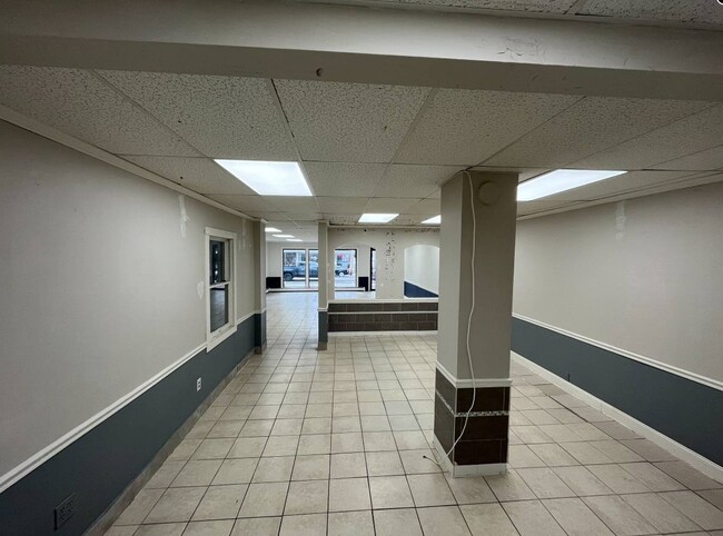
Current Lease Availabilities
NEARBY LISTINGS FOR SALE OR LEASE
Property Detail
363 Main St
Commercialofficeresidentialmixeduse
Barnstable
X
Massachusetts
25001C0736J
0.50 AC
2025
Cape Cod
2025
Other Market Areas
014800
Barnstable Town, MA
7,850 SF
FALM-000047B-000001-000014
DEMOGRAPHICS near 363 Main St
1 Mile
3 Mile
5 Mile
2024 Total Population
4,773
16,711
28,416
2029 Population
4,984
17,627
29,816
Pop Growth 2024-2029
+ 4.42%
+ 5.48%
+ 4.93%
Average Age
55
52
51
2024 Total Households
2,671
8,268
13,339
HH Growth 2024-2029
+ 3.89%
+ 5.15%
+ 4.74%
Median Household Inc
$66,243
$82,074
$80,447
Avg Household Size
1.70
2.00
2.10
2024 Avg HH Vehicles
1.00
2.00
2.00
Median Home Value
$700,206
$595,622
$545,562
Median Year Built
1962
1971
1973
Nearby Places
- Restaurants
- Banks
- Shops
- Fitness
- Groceries
PUBLIC TRANSPORTATION
AIRPORT
Martha's Vineyard
DRIVE
WALK
Distance
Martha's Vineyard
69 min
17.8 mi
Nearby Properties
Address
Land Use
TOTAL SIZE
Lot Size
Zoning
Address
Land Use
TOTAL SIZE
Lot Size
Zoning
276,514 SF
38.06 AC
B2
Address
Land Use
TOTAL SIZE
Lot Size
Zoning
387.44 AC
RA
Address
Land Use
TOTAL SIZE
Lot Size
Zoning
124,999 SF
10 AC
PU
Address
Land Use
TOTAL SIZE
Lot Size
Zoning
102,086 SF
20.95 AC
PU
Address
Land Use
TOTAL SIZE
Lot Size
Zoning
1,343.21 AC
PU
Address
Land Use
TOTAL SIZE
Lot Size
Zoning
81,184 SF
6.61 AC
PU
Address
Land Use
TOTAL SIZE
Lot Size
Zoning
125,628 SF
5.51 AC
AGB
Address
Land Use
TOTAL SIZE
Lot Size
Zoning
61,291 SF
13.43 AC
PU
Address
Land Use
TOTAL SIZE
Lot Size
Zoning
51,906 SF
24.35 AC
PU
Address
Land Use
TOTAL SIZE
Lot Size
Zoning
103,987 SF
10 AC
B2
Address
Land Use
TOTAL SIZE
Lot Size
Zoning
41,188 SF
3 AC
PU
Address
Land Use
TOTAL SIZE
Lot Size
Zoning
68,362 SF
4.91 AC
M
Address
Land Use
TOTAL SIZE
Lot Size
Zoning
65,159 SF
33.65 AC
B2
Address
Land Use
TOTAL SIZE
Lot Size
Zoning
33,157 SF
39.23 AC
PU
Address
Land Use
TOTAL SIZE
Lot Size
Zoning
56,592 SF
16.62 AC
PU
Address
Land Use
TOTAL SIZE
Lot Size
Zoning
15,302 SF
4.06 AC
RA
Address
Land Use
TOTAL SIZE
Lot Size
Zoning
166.90 AC
PU
Address
Land Use
TOTAL SIZE
Lot Size
Zoning
88,392 SF
9.20 AC
B2
Address
Land Use
TOTAL SIZE
Lot Size
Zoning
22,380 SF
5.05 AC
PU
Address
Land Use
TOTAL SIZE
Lot Size
Zoning
28,788 SF
14.15 AC
PU
Address
Land Use
TOTAL SIZE
Lot Size
Zoning
1,484 SF
88.31 AC
AGA
Address
Land Use
TOTAL SIZE
Lot Size
Zoning
15,546 SF
86.40 AC
PU
Address
Land Use
TOTAL SIZE
Lot Size
Zoning
94,732 SF
1 AC
BU
Address
Land Use
TOTAL SIZE
Lot Size
Zoning
21,360 SF
3.71 AC
GR
Address
Land Use
TOTAL SIZE
Lot Size
Zoning
100.93 AC
PU
Address
Land Use
TOTAL SIZE
Lot Size
Zoning
19,171 SF
5.43 AC
PU
Address
Land Use
TOTAL SIZE
Lot Size
Zoning
72,138 SF
6.27 AC
PU
Address
Land Use
TOTAL SIZE
Lot Size
Zoning
63,286 SF
5.73 AC
RC
Address
Land Use
TOTAL SIZE
Lot Size
Zoning
29.35 AC
PU
Address
Land Use
TOTAL SIZE
Lot Size
Zoning
7,119 SF
1.55 AC
RB
The World's #1 Commercial Real Estate Marketplace
Connect with us
© 2025 CoStar Group
The information above has been obtained from sources believed reliable. While we do not doubt its accuracy we have not verified it and make no guarantee, warranty or representation about it. It is your responsibility to independently confirm its accuracy and completeness. Any projections, opinions, assumptions, or estimates used are for example only and do not represent the current or future performance of the property. The value of this transaction to you depends on tax and other factors which should be evaluated by your tax, financial, and legal advisors. You and your advisors should conduct a careful, independent investigation of the property to determine to your satisfaction the suitability of the property for your needs.