Property Record
363 Cummings Ave Nw, Grand Rapids, MI 49534
NEARBY LISTINGS FOR SALE OR LEASE
-
-
View all Grand Rapids listings for sale on LoopNet.com
Property Detail
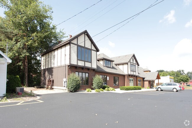
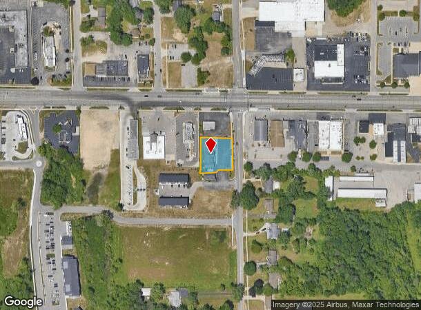
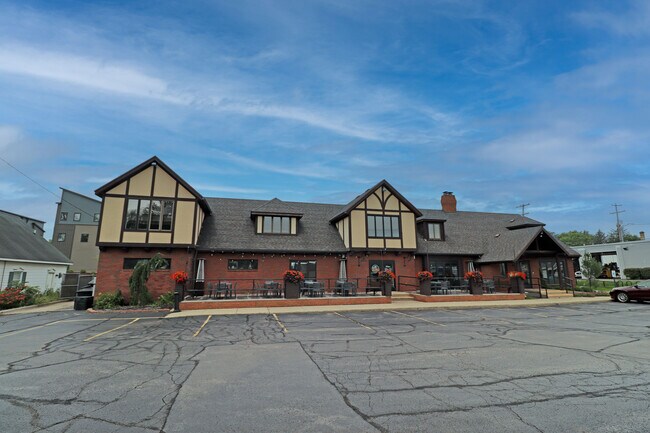
363 Cummings Ave Nw
41-13-30-201-071
411330201071 PART OF NE 1/4 COM 1325.83 FT S 88D 21M 31S E ALONG N SEC LINE & 150.0 FT S 0D 15M 49S E ALONG E LINE OF NW 1/4
Storebuilding
Kent
X
Michigan
26081C0382D
0.53 AC
2024
W Grand Rapids/Walker
2025
West Michigan
011702
Grand Rapids-Wyoming, MI
5,114 SF
DEMOGRAPHICS near 363 Cummings Ave Nw
1 Mile
3 Mile
5 Mile
2024 Total Population
6,456
31,704
104,231
2029 Population
6,521
32,395
105,681
Pop Growth 2024-2029
+ 1.01%
+ 2.18%
+ 1.39%
Average Age
38
41
38
2024 Total Households
2,854
13,077
41,069
HH Growth 2024-2029
+ 1.02%
+ 2.01%
+ 1.45%
Median Household Inc
$64,832
$75,762
$67,320
Avg Household Size
2.20
2.40
2.50
2024 Avg HH Vehicles
2.00
2.00
2.00
Median Home Value
$240,689
$246,763
$216,752
Median Year Built
1987
1980
1968
Nearby Places
Map Layers
Map Styles
 Street
 Aerial
- Restaurants
- Banks
- Shops
- Fitness
- Groceries
PUBLIC TRANSPORTATION
COMMUTER RAIL
Grand Rapids Vernon J. Ehlers Station (Pere Marquette - Amtrak)
DRIVE
WALK
Distance
Grand Rapids Vernon J. Ehlers Station (Pere Marquette - Amtrak)
11 min
5.8 mi
AIRPORT
Gerald R Ford International
DRIVE
WALK
Distance
Gerald R Ford International
31 min
20.1 mi
Freight Ports
Port Milwaukee
DRIVE
WALK
Distance
Port Milwaukee
303 min
260.2 mi
SALE & LEASE HISTORY
LISTING DATE
SALE/LEASE

Mar 06, 2023
For Sale
Nearby Properties
Address
Land Use
TOTAL SIZE
Lot Size
Zoning
Address
Land Use
TOTAL SIZE
Lot Size
Zoning
390,682 SF
47.73 AC
ARM - MULT
Address
Land Use
TOTAL SIZE
Lot Size
Zoning
389,181 SF
51.01 AC
RPUD - 2
Address
Land Use
TOTAL SIZE
Lot Size
Zoning
32.89 AC
TN-LDR
Address
Land Use
TOTAL SIZE
Lot Size
Zoning
343,973 SF
29.15 AC
MON-LDR
Address
Land Use
TOTAL SIZE
Lot Size
Zoning
245,620 SF
20.13 AC
RPUD - 2
Address
Land Use
TOTAL SIZE
Lot Size
Zoning
209,522 SF
27.89 AC
CPUD
Address
Land Use
TOTAL SIZE
Lot Size
Zoning
147,232 SF
18.42 AC
ARM - MULT
Address
Land Use
TOTAL SIZE
Lot Size
Zoning
107,800 SF
13.29 AC
CPUD
Address
Land Use
TOTAL SIZE
Lot Size
Zoning
Address
Land Use
TOTAL SIZE
Lot Size
Zoning
78,872 SF
3.09 AC
MON-LDR
Address
Land Use
TOTAL SIZE
Lot Size
Zoning
104,399 SF
16.83 AC
ML
Address
Land Use
TOTAL SIZE
Lot Size
Zoning
53,653 SF
1.81 AC
MON-MDR
Address
Land Use
TOTAL SIZE
Lot Size
Zoning
37,268 SF
3.32 AC
Address
Land Use
TOTAL SIZE
Lot Size
Zoning
51,232 SF
5.04 AC
MCN-C
Address
Land Use
TOTAL SIZE
Lot Size
Zoning
1,992 SF
48.64 AC
RMT
Address
Land Use
TOTAL SIZE
Lot Size
Zoning
53,600 SF
Address
Land Use
TOTAL SIZE
Lot Size
Zoning
67,821 SF
4.95 AC
Address
Land Use
TOTAL SIZE
Lot Size
Zoning
2,173 SF
40.87 AC
RMT
Address
Land Use
TOTAL SIZE
Lot Size
Zoning
78,451 SF
4.57 AC
Address
Land Use
TOTAL SIZE
Lot Size
Zoning
67,180 SF
12.68 AC
MH
Address
Land Use
TOTAL SIZE
Lot Size
Zoning
166.62 AC
A
Address
Land Use
TOTAL SIZE
Lot Size
Zoning
13,255 SF
1.36 AC
CPUD
Address
Land Use
TOTAL SIZE
Lot Size
Zoning
62,978 SF
7.58 AC
Address
Land Use
TOTAL SIZE
Lot Size
Zoning
19,078 SF
3.46 AC
CPUD
Address
Land Use
TOTAL SIZE
Lot Size
Zoning
77,750 SF
5.46 AC
IPUD
Address
Land Use
TOTAL SIZE
Lot Size
Zoning
36,975 SF
Address
Land Use
TOTAL SIZE
Lot Size
Zoning
16,734 SF
3.76 AC
ORP
Address
Land Use
TOTAL SIZE
Lot Size
Zoning
20,020 SF
1.90 AC
C-1
Address
Land Use
TOTAL SIZE
Lot Size
Zoning
67,793 SF
12.70 AC
MH
Address
Land Use
TOTAL SIZE
Lot Size
Zoning
14,591 SF
6.38 AC
C-1
The World's #1 Commercial Real Estate Marketplace
Connect with us
© 2025 CoStar Group
The information above has been obtained from sources believed reliable. While we do not doubt its accuracy we have not verified it and make no guarantee, warranty or representation about it. It is your responsibility to independently confirm its accuracy and completeness. Any projections, opinions, assumptions, or estimates used are for example only and do not represent the current or future performance of the property. The value of this transaction to you depends on tax and other factors which should be evaluated by your tax, financial, and legal advisors. You and your advisors should conduct a careful, independent investigation of the property to determine to your satisfaction the suitability of the property for your needs.