Property Record
363 Reef Rd, Fairfield, CT 06824
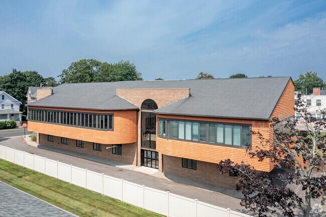
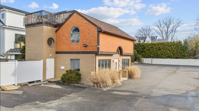
Property Detail
363 Reef Rd
FAIR-000182-000000-000214-A000000
FAIRFIELD
Commercialnec
Connecticut
NDBD
0.66 AC
AE The base floodplain where base flood elevations are provided. AE Zones are now used on new format FIRMs instead of A1-A30 Zones.
Fairfield
2025
Westchester/So Connecticut
2025
Bridgeport-Stamford-Danbury, CT
061500
NEARBY LISTINGS FOR SALE OR LEASE
DEMOGRAPHICS near 363 Reef Rd
1 mile
3 mile
5 mile
2025 Total Population
10,259
51,766
139,644
2030 Population
10,702
53,597
143,551
Pop Growth 2025-2030
+ 4.32%
+ 3.54%
+ 2.80%
Average Age
42
40
39
2025 Total Households
3,835
18,983
50,115
HH Growth 2025-2030
+ 4.38%
+ 3.79%
+ 2.91%
Median Household Inc
$214,147
$150,024
$97,964
Avg Household Size
2.60
2.50
2.60
2025 Avg HH Vehicles
2.00
2.00
2.00
Median Home Value
$932,749
$791,622
$712,090
Median Year Built
1956
1961
1956
Nearby Places
Map Layers
Map Styles
 Street
 Aerial
Layers
 Traffic
 Biking
Places
Listings with unknown addresses are not visible on the map
- Restaurants
- Banks
- Shops
- Fitness
- Groceries
PUBLIC TRANSPORTATION
TRANSIT/SUBWAY
Fairfield Station (New Haven Line - Metro-North Commuter Railroad Company (Metro-North))
Drive
Walk
Distance
Fairfield Station (New Haven Line - Metro-North Commuter Railroad Company (Metro-North))
2 min
15 min
0.5 mi
COMMUTER RAIL
Fairfield Station (New Haven Line - Metro-North Commuter Railroad Company (Metro-North))
Drive
Walk
Distance
Fairfield Station (New Haven Line - Metro-North Commuter Railroad Company (Metro-North))
2 min
15 min
0.6 mi
Southport Station (New Haven Line - Metro-North Commuter Railroad Company (Metro-North))
Drive
Walk
Distance
Southport Station (New Haven Line - Metro-North Commuter Railroad Company (Metro-North))
5 min
2.1 mi
AIRPORT
Tweed/New Haven
Drive
Walk
Distance
Tweed/New Haven
43 min
27.8 mi
Westchester County
Drive
Walk
Distance
Westchester County
47 min
30.0 mi
Long Island MacArthur
Drive
Walk
Distance
Long Island MacArthur
116 min
39.3 mi
Freight Ports
Port of New Haven
Drive
Walk
Distance
Port of New Haven
38 min
24.9 mi
SALE & LEASE HISTORY
LISTING DATE
SALE/LEASE

May 03, 2019
For Lease
Apr 16, 2025
For Lease
Nearby Properties
Address
Land Use
TOTAL SIZE
Lot Size
Zoning
Address
Land Use
TOTAL SIZE
Lot Size
Zoning
124 AC
FPD
Address
Land Use
TOTAL SIZE
Lot Size
Zoning
19.43 AC
A
Address
Land Use
TOTAL SIZE
Lot Size
Zoning
1,183 SF
2.33 AC
DID
Address
Land Use
TOTAL SIZE
Lot Size
Zoning
213,826 SF
18.30 AC
A
Address
Land Use
TOTAL SIZE
Lot Size
Zoning
10.28 AC
DID
Address
Land Use
TOTAL SIZE
Lot Size
Zoning
260,992 SF
4.19 AC
ILI
Address
Land Use
TOTAL SIZE
Lot Size
Zoning
85,050 SF
6.76 AC
GBD
Address
Land Use
TOTAL SIZE
Lot Size
Zoning
144,086 SF
3.12 AC
DRD
Address
Land Use
TOTAL SIZE
Lot Size
Zoning
115,006 SF
2.51 AC
DCD
Address
Land Use
TOTAL SIZE
Lot Size
Zoning
12.47 AC
AA
Address
Land Use
TOTAL SIZE
Lot Size
Zoning
23.70 AC
AAA
Address
Land Use
TOTAL SIZE
Lot Size
Zoning
14.90 AC
RC
Address
Land Use
TOTAL SIZE
Lot Size
Zoning
16.73 AC
DCD
Address
Land Use
TOTAL SIZE
Lot Size
Zoning
6.43 AC
DCD
Address
Land Use
TOTAL SIZE
Lot Size
Zoning
92,057 SF
10.20 AC
B
Address
Land Use
TOTAL SIZE
Lot Size
Zoning
73,120 SF
22.33 AC
DID
Address
Land Use
TOTAL SIZE
Lot Size
Zoning
76,811 SF
4.25 AC
RC
Address
Land Use
TOTAL SIZE
Lot Size
Zoning
Address
Land Use
TOTAL SIZE
Lot Size
Zoning
9.63 AC
AA
Address
Land Use
TOTAL SIZE
Lot Size
Zoning
66,254 SF
22.74 AC
AA
Address
Land Use
TOTAL SIZE
Lot Size
Zoning
5.82 AC
AA
Address
Land Use
TOTAL SIZE
Lot Size
Zoning
77,764 SF
A
Address
Land Use
TOTAL SIZE
Lot Size
Zoning
98,056 SF
9.19 AC
DCD
Address
Land Use
TOTAL SIZE
Lot Size
Zoning
15,542 SF
3.54 AC
A
Address
Land Use
TOTAL SIZE
Lot Size
Zoning
14.32 AC
RC
Address
Land Use
TOTAL SIZE
Lot Size
Zoning
113,468 SF
7.96 AC
DCD
Address
Land Use
TOTAL SIZE
Lot Size
Zoning
14,647 SF
6 AC
A
Address
Land Use
TOTAL SIZE
Lot Size
Zoning
77,181 SF
6.42 AC
GBD
Address
Land Use
TOTAL SIZE
Lot Size
Zoning
18.55 AC
A
Address
Land Use
TOTAL SIZE
Lot Size
Zoning
121,033 SF
13.92 AC
DI
The World's #1 Commercial Real Estate Marketplace
Connect with us
© 2026 CoStar Group
The information above has been obtained from sources believed reliable. While we do not doubt its accuracy we have not verified it and make no guarantee, warranty or representation about it. It is your responsibility to independently confirm its accuracy and completeness. Any projections, opinions, assumptions, or estimates used are for example only and do not represent the current or future performance of the property. The value of this transaction to you depends on tax and other factors which should be evaluated by your tax, financial, and legal advisors. You and your advisors should conduct a careful, independent investigation of the property to determine to your satisfaction the suitability of the property for your needs.