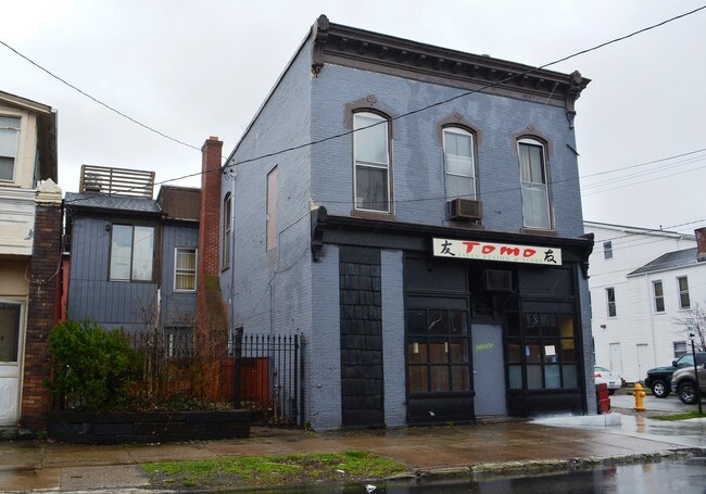
Property Record
363 W 8Th St, Erie, PA 16502
NEARBY LISTINGS FOR SALE OR LEASE
Property Detail
363 W 8Th St
16-030-020.0-220.00
363 W 8 ST X 803 05 CHESTNUT
Bartavern
Erie
X
Pennsylvania
42049C0205E
0.06 AC
2025
Downtown Erie
2025
Erie
000902
Erie, PA
2,088 SF
DEMOGRAPHICS near 363 W 8Th St
1 Mile
3 Mile
5 Mile
2024 Total Population
19,101
88,454
148,397
2029 Population
19,052
87,540
146,873
Pop Growth 2024-2029
(0.26%)
(1.03%)
(1.03%)
Average Age
37
39
40
2024 Total Households
8,323
36,396
61,923
HH Growth 2024-2029
(0.26%)
(1.13%)
(1.11%)
Median Household Inc
$23,893
$41,754
$49,301
Avg Household Size
2.00
2.20
2.20
2024 Avg HH Vehicles
1.00
1.00
1.00
Median Home Value
$67,746
$92,573
$126,470
Median Year Built
1948
1949
1956
Nearby Places
Map Layers
Map Styles
 Street
 Aerial
- Restaurants
- Banks
- Shops
- Fitness
- Groceries
PUBLIC TRANSPORTATION
AIRPORT
Erie International/Tom Ridge Field
DRIVE
WALK
Distance
Erie International/Tom Ridge Field
12 min
5.5 mi
SALE & LEASE HISTORY
LISTING DATE
SALE/LEASE

Jul 30, 2024
For Lease
Nearby Properties
Address
Land Use
TOTAL SIZE
Lot Size
Zoning
Address
Land Use
TOTAL SIZE
Lot Size
Zoning
31,764 SF
46.83 AC
R3
Address
Land Use
TOTAL SIZE
Lot Size
Zoning
583,648 SF
5.55 AC
WC2
Address
Land Use
TOTAL SIZE
Lot Size
Zoning
2.73 AC
C3
Address
Land Use
TOTAL SIZE
Lot Size
Zoning
172,806 SF
1.88 AC
WC2
Address
Land Use
TOTAL SIZE
Lot Size
Zoning
630,344 SF
7.57 AC
RLB
Address
Land Use
TOTAL SIZE
Lot Size
Zoning
12.27 AC
WM
Address
Land Use
TOTAL SIZE
Lot Size
Zoning
5 AC
RLB
Address
Land Use
TOTAL SIZE
Lot Size
Zoning
3.38 AC
RLB
Address
Land Use
TOTAL SIZE
Lot Size
Zoning
3.10 AC
WC
Address
Land Use
TOTAL SIZE
Lot Size
Zoning
189,344 SF
2.14 AC
C3
Address
Land Use
TOTAL SIZE
Lot Size
Zoning
138,119 SF
11.39 AC
Address
Land Use
TOTAL SIZE
Lot Size
Zoning
103,358 SF
2.77 AC
WC
Address
Land Use
TOTAL SIZE
Lot Size
Zoning
800 SF
10.05 AC
R2
Address
Land Use
TOTAL SIZE
Lot Size
Zoning
375,929 SF
5.02 AC
C3
Address
Land Use
TOTAL SIZE
Lot Size
Zoning
3,401 SF
3,161.16 AC
Address
Land Use
TOTAL SIZE
Lot Size
Zoning
148,615 SF
19.77 AC
Address
Land Use
TOTAL SIZE
Lot Size
Zoning
1.56 AC
C3
Address
Land Use
TOTAL SIZE
Lot Size
Zoning
170,870 SF
4.51 AC
RLB
Address
Land Use
TOTAL SIZE
Lot Size
Zoning
117,879 SF
13.47 AC
M1
Address
Land Use
TOTAL SIZE
Lot Size
Zoning
2.45 AC
RLB
Address
Land Use
TOTAL SIZE
Lot Size
Zoning
171,966 SF
13.99 AC
RB
Address
Land Use
TOTAL SIZE
Lot Size
Zoning
8.60 AC
R2
Address
Land Use
TOTAL SIZE
Lot Size
Zoning
163,596 SF
14.31 AC
C2
Address
Land Use
TOTAL SIZE
Lot Size
Zoning
0.66 AC
C3
Address
Land Use
TOTAL SIZE
Lot Size
Zoning
178,236 SF
26.15 AC
RLB
Address
Land Use
TOTAL SIZE
Lot Size
Zoning
73,971 SF
1.49 AC
WC
Address
Land Use
TOTAL SIZE
Lot Size
Zoning
10.62 AC
R2
Address
Land Use
TOTAL SIZE
Lot Size
Zoning
88,232 SF
1 AC
RLB
Address
Land Use
TOTAL SIZE
Lot Size
Zoning
47,635 SF
2.97 AC
R1
Address
Land Use
TOTAL SIZE
Lot Size
Zoning
4,600 SF
50.38 AC
R3
The World's #1 Commercial Real Estate Marketplace
Connect with us
© 2025 CoStar Group
The information above has been obtained from sources believed reliable. While we do not doubt its accuracy we have not verified it and make no guarantee, warranty or representation about it. It is your responsibility to independently confirm its accuracy and completeness. Any projections, opinions, assumptions, or estimates used are for example only and do not represent the current or future performance of the property. The value of this transaction to you depends on tax and other factors which should be evaluated by your tax, financial, and legal advisors. You and your advisors should conduct a careful, independent investigation of the property to determine to your satisfaction the suitability of the property for your needs.