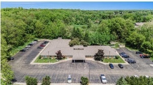
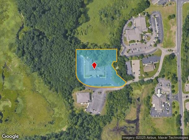
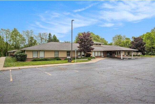
Property Record
3630 Capital Ave Sw, Battle Creek, MI 49015
NEARBY LISTINGS FOR SALE OR LEASE
Property Detail
3630 Capital Ave Sw
0085-00-912-0
SEC 35 T2S R8W PART OF SE 1/4 OF SE 1/4 DESC AS COMM SE COR OF SD SEC - N 00 DEG 24 MIN 25 SEC E ALG E SEC LI 657.73 FT - N
Medicalbuilding
Calhoun
X
Michigan
26025C0330C
3.05 AC
0
Battle Crk/W Calhoun Cnty
2025
West Michigan
001802
Battle Creek, MI
810 SF
DEMOGRAPHICS near 3630 Capital Ave Sw
1 Mile
3 Mile
5 Mile
2024 Total Population
4,307
15,458
41,798
2029 Population
4,283
15,183
41,232
Pop Growth 2024-2029
(0.56%)
(1.78%)
(1.35%)
Average Age
38
42
40
2024 Total Households
2,064
6,538
16,786
HH Growth 2024-2029
(0.34%)
(1.62%)
(1.34%)
Median Household Inc
$40,798
$81,023
$62,469
Avg Household Size
2.00
2.30
2.40
2024 Avg HH Vehicles
1.00
2.00
2.00
Median Home Value
$189,150
$199,350
$155,998
Median Year Built
1988
1978
1960
Nearby Places
Map Layers
Map Styles
 Street
 Aerial
- Restaurants
- Banks
- Shops
- Fitness
- Groceries
PUBLIC TRANSPORTATION
COMMUTER RAIL
Battle Creek (Blue Water - Amtrak, Wolverine - Amtrak)
DRIVE
WALK
Distance
Battle Creek (Blue Water - Amtrak, Wolverine - Amtrak)
10 min
6.2 mi
AIRPORT
Kalamazoo/Battle Creek International
DRIVE
WALK
Distance
Kalamazoo/Battle Creek International
32 min
22.3 mi
Freight Ports
Port of Toledo
DRIVE
WALK
Distance
Port of Toledo
154 min
124.7 mi
Nearby Properties
Address
Land Use
TOTAL SIZE
Lot Size
Zoning
Address
Land Use
TOTAL SIZE
Lot Size
Zoning
214,023 SF
35.60 AC
MFR
Address
Land Use
TOTAL SIZE
Lot Size
Zoning
205,436 SF
9.88 AC
MFR
Address
Land Use
TOTAL SIZE
Lot Size
Zoning
69,435 SF
24.84 AC
MFR
Address
Land Use
TOTAL SIZE
Lot Size
Zoning
63,180 SF
3.55 AC
RC
Address
Land Use
TOTAL SIZE
Lot Size
Zoning
135,286 SF
21.86 AC
MFR
Address
Land Use
TOTAL SIZE
Lot Size
Zoning
309,945 SF
25.02 AC
MFR
Address
Land Use
TOTAL SIZE
Lot Size
Zoning
131,048 SF
12.28 AC
R1A
Address
Land Use
TOTAL SIZE
Lot Size
Zoning
79,074 SF
4.98 AC
RC
Address
Land Use
TOTAL SIZE
Lot Size
Zoning
221,522 SF
23.23 AC
RC
Address
Land Use
TOTAL SIZE
Lot Size
Zoning
196,120 SF
21.42 AC
RC
Address
Land Use
TOTAL SIZE
Lot Size
Zoning
137,827 SF
20.09 AC
B2
Address
Land Use
TOTAL SIZE
Lot Size
Zoning
192,680 SF
21.66 AC
RC
Address
Land Use
TOTAL SIZE
Lot Size
Zoning
63,180 SF
12.12 AC
RC
Address
Land Use
TOTAL SIZE
Lot Size
Zoning
81,376 SF
7.82 AC
MFR
Address
Land Use
TOTAL SIZE
Lot Size
Zoning
65,773 SF
2.42 AC
RC
Address
Land Use
TOTAL SIZE
Lot Size
Zoning
56,349 SF
7.54 AC
RC
Address
Land Use
TOTAL SIZE
Lot Size
Zoning
66,096 SF
9.71 AC
MFR
Address
Land Use
TOTAL SIZE
Lot Size
Zoning
124,141 SF
21.18 AC
RC
Address
Land Use
TOTAL SIZE
Lot Size
Zoning
81,857 SF
9.29 AC
RC
Address
Land Use
TOTAL SIZE
Lot Size
Zoning
366,290 SF
31.87 AC
B2
Address
Land Use
TOTAL SIZE
Lot Size
Zoning
44,034 SF
1.60 AC
RC
Address
Land Use
TOTAL SIZE
Lot Size
Zoning
72,260 SF
12.33 AC
B2
Address
Land Use
TOTAL SIZE
Lot Size
Zoning
78,000 SF
8.21 AC
MFR
Address
Land Use
TOTAL SIZE
Lot Size
Zoning
79,457 SF
8.60 AC
MFR
Address
Land Use
TOTAL SIZE
Lot Size
Zoning
124,280 SF
10.16 AC
B2
Address
Land Use
TOTAL SIZE
Lot Size
Zoning
87,535 SF
7.98 AC
B2
Address
Land Use
TOTAL SIZE
Lot Size
Zoning
85,654 SF
12.12 AC
RC
Address
Land Use
TOTAL SIZE
Lot Size
Zoning
27,393 SF
6.86 AC
MFR
Address
Land Use
TOTAL SIZE
Lot Size
Zoning
41,310 SF
3.53 AC
B2
Address
Land Use
TOTAL SIZE
Lot Size
Zoning
102,265 SF
8.41 AC
B2
The World's #1 Commercial Real Estate Marketplace
Connect with us
© 2025 CoStar Group
The information above has been obtained from sources believed reliable. While we do not doubt its accuracy we have not verified it and make no guarantee, warranty or representation about it. It is your responsibility to independently confirm its accuracy and completeness. Any projections, opinions, assumptions, or estimates used are for example only and do not represent the current or future performance of the property. The value of this transaction to you depends on tax and other factors which should be evaluated by your tax, financial, and legal advisors. You and your advisors should conduct a careful, independent investigation of the property to determine to your satisfaction the suitability of the property for your needs.