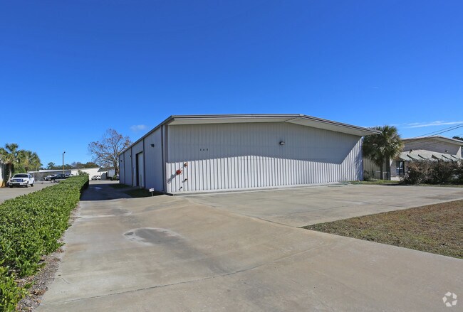
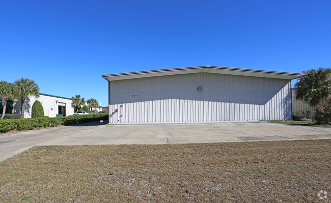
Property Record
3630 Community Rd, Brunswick, GA 31520


NEARBY LISTINGS FOR SALE OR LEASE
Property Detail
3630 Community Rd
01-06978
0078-30
Commercialnec
2.04 AC COMMUNITY RD
X
Glynn
13127C0228H
Georgia
2025
35
2025
1.99 AC
000701
Other Market Areas
29,402 SF
Brunswick-St. Simons, GA
DEMOGRAPHICS near 3630 Community Rd
1 mile
3 mile
5 mile
2024 Total Population
3,925
27,911
43,185
2029 Population
3,900
27,829
43,263
Pop Growth 2024-2029
(0.64%)
(0.29%)
+ 0.18%
Average Age
42
41
41
2024 Total Households
1,527
10,702
16,784
HH Growth 2024-2029
(1.05%)
(0.71%)
(0.13%)
Median Household Inc
$40,379
$39,217
$44,521
Avg Household Size
2.30
2.40
2.40
2024 Avg HH Vehicles
2.00
2.00
2.00
Median Home Value
$133,564
$134,379
$156,222
Median Year Built
1980
1977
1982
Nearby Places
Map Layers
Map Styles
 Street
 Aerial
Transit
 Traffic
 Biking
Places
Listings with unknown addresses are not visible on the map
- Restaurants
- Banks
- Shops
- Fitness
- Groceries
PUBLIC TRANSPORTATION
AIRPORT
Brunswick Golden Isles
Drive
Walk
Distance
Brunswick Golden Isles
12 min
6.6 mi
Freight Ports
Georgia Ports - Brunswick
Drive
Walk
Distance
Georgia Ports - Brunswick
20 min
11.5 mi
Nearby Properties
Address
Land Use
TOTAL SIZE
Lot Size
Zoning
Address
Land Use
TOTAL SIZE
Lot Size
Zoning
19.59 AC
MED
Address
Land Use
TOTAL SIZE
Lot Size
Zoning
57.20 AC
R9
Address
Land Use
TOTAL SIZE
Lot Size
Zoning
90.50 AC
R9
Address
Land Use
TOTAL SIZE
Lot Size
Zoning
283.18 AC
CP
Address
Land Use
TOTAL SIZE
Lot Size
Zoning
41.94 AC
PD
Address
Land Use
TOTAL SIZE
Lot Size
Zoning
23.99 AC
PD
Address
Land Use
TOTAL SIZE
Lot Size
Zoning
31.68 AC
BI
Address
Land Use
TOTAL SIZE
Lot Size
Zoning
15.08 AC
MR
Address
Land Use
TOTAL SIZE
Lot Size
Zoning
10.85 AC
PD
Address
Land Use
TOTAL SIZE
Lot Size
Zoning
13 AC
PDS
Address
Land Use
TOTAL SIZE
Lot Size
Zoning
10.59 AC
PD
Address
Land Use
TOTAL SIZE
Lot Size
Zoning
4.93 AC
HC
Address
Land Use
TOTAL SIZE
Lot Size
Zoning
13.33 AC
MR
Address
Land Use
TOTAL SIZE
Lot Size
Zoning
0.12 AC
OC
Address
Land Use
TOTAL SIZE
Lot Size
Zoning
9.94 AC
HC
Address
Land Use
TOTAL SIZE
Lot Size
Zoning
4,096 SF
14.69 AC
MR
Address
Land Use
TOTAL SIZE
Lot Size
Zoning
10.45 AC
MR
Address
Land Use
TOTAL SIZE
Lot Size
Zoning
6.75 AC
PDR
Address
Land Use
TOTAL SIZE
Lot Size
Zoning
20 AC
HC
Address
Land Use
TOTAL SIZE
Lot Size
Zoning
14.84 AC
PD
Address
Land Use
TOTAL SIZE
Lot Size
Zoning
14.66 AC
PD
Address
Land Use
TOTAL SIZE
Lot Size
Zoning
18.45 AC
MR
Address
Land Use
TOTAL SIZE
Lot Size
Zoning
11.67 AC
HC
Address
Land Use
TOTAL SIZE
Lot Size
Zoning
11.52 AC
PDR
Address
Land Use
TOTAL SIZE
Lot Size
Zoning
0.91 AC
GC
Address
Land Use
TOTAL SIZE
Lot Size
Zoning
55,647 SF
8.17 AC
HC
Address
Land Use
TOTAL SIZE
Lot Size
Zoning
8.50 AC
PD
Address
Land Use
TOTAL SIZE
Lot Size
Zoning
4.09 AC
PD
Address
Land Use
TOTAL SIZE
Lot Size
Zoning
9.54 AC
HC
Address
Land Use
TOTAL SIZE
Lot Size
Zoning
2.03 AC
PD
The World's #1 Commercial Real Estate Marketplace
Connect with us
© 2026 CoStar Group
The information above has been obtained from sources believed reliable. While we do not doubt its accuracy we have not verified it and make no guarantee, warranty or representation about it. It is your responsibility to independently confirm its accuracy and completeness. Any projections, opinions, assumptions, or estimates used are for example only and do not represent the current or future performance of the property. The value of this transaction to you depends on tax and other factors which should be evaluated by your tax, financial, and legal advisors. You and your advisors should conduct a careful, independent investigation of the property to determine to your satisfaction the suitability of the property for your needs.