Property Record
36321 State Highway 79, Cleveland, AL 35049


NEARBY LISTINGS FOR SALE OR LEASE
-
-
View all Cleveland listings for sale on LoopNet.com
Property Detail
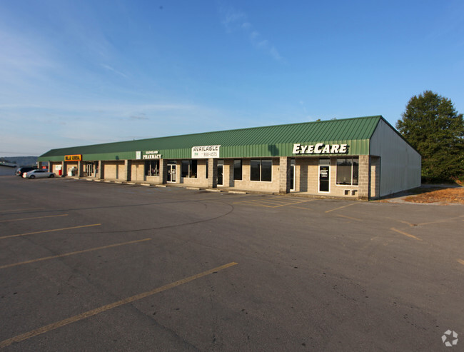
36321 State Highway 79
14-06-13-0-000-077.003
COM NE COR SE/SE SWLY 643 TO W R/W ST HWY 79 SLY 527 ALG HWY SWLY 234 ALG R/W ST HWY 160 TO POB CONT WLY 228 ALG HWY 160 N
Storesoffices
Blount
X
Alabama
01009C0305F
1.40 AC
2025
Blount County
2024
Birmingham
050200
Birmingham-Hoover, AL
14,300 SF
DEMOGRAPHICS near 36321 State Highway 79
1 Mile
3 Mile
5 Mile
2024 Total Population
626
2,759
6,293
2029 Population
626
2,771
6,330
Pop Growth 2024-2029
0.00%
+ 0.43%
+ 0.59%
Average Age
40
39
40
2024 Total Households
230
1,011
2,345
HH Growth 2024-2029
0.00%
+ 0.40%
+ 0.55%
Median Household Inc
$43,055
$49,142
$52,294
Avg Household Size
2.70
2.60
2.60
2024 Avg HH Vehicles
3.00
3.00
3.00
Median Home Value
$101,250
$130,281
$151,359
Median Year Built
1982
1985
1984
Nearby Places
Map Layers
Map Styles
 Street
 Aerial
- Restaurants
- Banks
- Shops
- Fitness
- Groceries
Nearby Properties
Address
Land Use
TOTAL SIZE
Lot Size
Zoning
Address
Land Use
TOTAL SIZE
Lot Size
Zoning
21,876 SF
3.10 AC
Address
Land Use
TOTAL SIZE
Lot Size
Zoning
4,200 SF
3 AC
Address
Land Use
TOTAL SIZE
Lot Size
Zoning
10,332 SF
1.90 AC
Address
Land Use
TOTAL SIZE
Lot Size
Zoning
Address
Land Use
TOTAL SIZE
Lot Size
Zoning
7,177 SF
1.60 AC
Address
Land Use
TOTAL SIZE
Lot Size
Zoning
7,893 SF
4.50 AC
Address
Land Use
TOTAL SIZE
Lot Size
Zoning
8,417 SF
0.50 AC
Address
Land Use
TOTAL SIZE
Lot Size
Zoning
15,500 SF
3.60 AC
Address
Land Use
TOTAL SIZE
Lot Size
Zoning
7,200 SF
1.20 AC
Address
Land Use
TOTAL SIZE
Lot Size
Zoning
5,700 SF
1.40 AC
Address
Land Use
TOTAL SIZE
Lot Size
Zoning
11,248 SF
2.20 AC
Address
Land Use
TOTAL SIZE
Lot Size
Zoning
16,108 SF
0.60 AC
Address
Land Use
TOTAL SIZE
Lot Size
Zoning
5,916 SF
2.50 AC
Address
Land Use
TOTAL SIZE
Lot Size
Zoning
4,280 SF
2 AC
Address
Land Use
TOTAL SIZE
Lot Size
Zoning
5,996 SF
0.70 AC
Address
Land Use
TOTAL SIZE
Lot Size
Zoning
5,000 SF
0.87 AC
Address
Land Use
TOTAL SIZE
Lot Size
Zoning
4,922 SF
1.05 AC
Address
Land Use
TOTAL SIZE
Lot Size
Zoning
8,000 SF
1.30 AC
Address
Land Use
TOTAL SIZE
Lot Size
Zoning
8,600 SF
1.23 AC
Address
Land Use
TOTAL SIZE
Lot Size
Zoning
6,750 SF
0.80 AC
Address
Land Use
TOTAL SIZE
Lot Size
Zoning
3,866 SF
0.80 AC
Address
Land Use
TOTAL SIZE
Lot Size
Zoning
2,195 SF
1 AC
Address
Land Use
TOTAL SIZE
Lot Size
Zoning
8,240 SF
2.80 AC
Address
Land Use
TOTAL SIZE
Lot Size
Zoning
2,600 SF
67 AC
The World's #1 Commercial Real Estate Marketplace
Connect with us
© 2026 CoStar Group
The information above has been obtained from sources believed reliable. While we do not doubt its accuracy we have not verified it and make no guarantee, warranty or representation about it. It is your responsibility to independently confirm its accuracy and completeness. Any projections, opinions, assumptions, or estimates used are for example only and do not represent the current or future performance of the property. The value of this transaction to you depends on tax and other factors which should be evaluated by your tax, financial, and legal advisors. You and your advisors should conduct a careful, independent investigation of the property to determine to your satisfaction the suitability of the property for your needs.