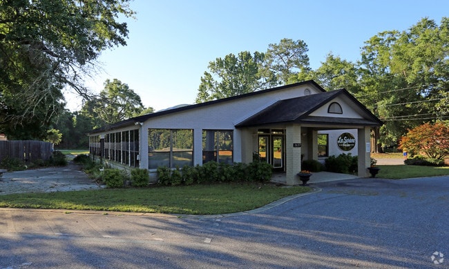
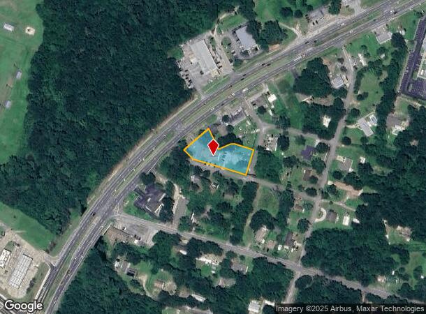
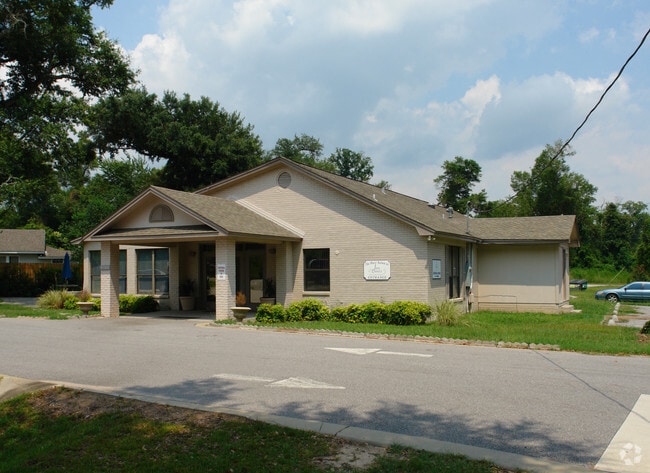
Property Record
3637 Highway 90, Milton, FL 32571
NEARBY LISTINGS FOR SALE OR LEASE
Property Detail
3637 Highway 90
Pensacola-Ferry Pass-Brent, FL
Floridatown Heights
23-1N-29-1240-00900-0090
*DES IN MORE DETAIL FOR 2013* FLORIDATOWN HEIGHTS BEING A RESUB OF FLORIDATOWN ADD PORT LOTS 9 10 11 12 13 14 15 17 & 18 BLK 9 (PB A PG 23) BEING MORE FULLY DES AS FOLLOWS: COM AT PT ON E LI OF SAID LOT 9 AT I/S WITH S R/W LI OF HWY 90 THN SELY ALNG
Commercialnec
Santa Rosa
X
Florida
12113C0406H
9
2024
1.11 AC
2025
Avalon Beach/Milton
010705
Pensacola
3,624 SF
DEMOGRAPHICS near 3637 Highway 90
1 Mile
3 Mile
5 Mile
2024 Total Population
2,677
16,054
46,529
2029 Population
3,048
18,370
52,679
Pop Growth 2024-2029
+ 13.86%
+ 14.43%
+ 13.22%
Average Age
39
39
40
2024 Total Households
1,006
5,960
16,844
HH Growth 2024-2029
+ 14.21%
+ 14.70%
+ 13.57%
Median Household Inc
$73,208
$70,559
$77,648
Avg Household Size
2.60
2.70
2.70
2024 Avg HH Vehicles
2.00
2.00
2.00
Median Home Value
$236,298
$244,722
$260,150
Median Year Built
1988
1992
1996
Nearby Places
Map Layers
Map Styles
 Street
 Aerial
- Restaurants
- Banks
- Shops
- Fitness
- Groceries
PUBLIC TRANSPORTATION
AIRPORT
Pensacola International
DRIVE
WALK
Distance
Pensacola International
22 min
11.7 mi
SALE & LEASE HISTORY
LISTING DATE
SALE/LEASE

Oct 18, 2016
For Lease
Nearby Properties
Address
Land Use
TOTAL SIZE
Lot Size
Zoning
Address
Land Use
TOTAL SIZE
Lot Size
Zoning
130,379 SF
18.18 AC
HCD
Address
Land Use
TOTAL SIZE
Lot Size
Zoning
154,042 SF
10.36 AC
HCD
Address
Land Use
TOTAL SIZE
Lot Size
Zoning
47.05 AC
AG-RR
Address
Land Use
TOTAL SIZE
Lot Size
Zoning
151,084 SF
19.01 AC
HCD
Address
Land Use
TOTAL SIZE
Lot Size
Zoning
81,123 SF
8.78 AC
HCD
Address
Land Use
TOTAL SIZE
Lot Size
Zoning
60,129 SF
0.11 AC
HCD
Address
Land Use
TOTAL SIZE
Lot Size
Zoning
13.70 AC
HCD
Address
Land Use
TOTAL SIZE
Lot Size
Zoning
76,674 SF
2.80 AC
HCD
Address
Land Use
TOTAL SIZE
Lot Size
Zoning
93,476 SF
7.43 AC
HCD
Address
Land Use
TOTAL SIZE
Lot Size
Zoning
389.54 AC
AG-RR
Address
Land Use
TOTAL SIZE
Lot Size
Zoning
112,196 SF
343.01 AC
HCD
Address
Land Use
TOTAL SIZE
Lot Size
Zoning
50,616 SF
2.56 AC
R3
Address
Land Use
TOTAL SIZE
Lot Size
Zoning
30,564 SF
11.12 AC
HCD
Address
Land Use
TOTAL SIZE
Lot Size
Zoning
23,668 SF
2.30 AC
HCD
Address
Land Use
TOTAL SIZE
Lot Size
Zoning
49,275 SF
2.49 AC
HCD
Address
Land Use
TOTAL SIZE
Lot Size
Zoning
13,560 SF
5.93 AC
HCD
Address
Land Use
TOTAL SIZE
Lot Size
Zoning
45,485 SF
6.49 AC
HCD
Address
Land Use
TOTAL SIZE
Lot Size
Zoning
62,174 SF
4 AC
HCD
Address
Land Use
TOTAL SIZE
Lot Size
Zoning
25,326 SF
2.80 AC
HCD
Address
Land Use
TOTAL SIZE
Lot Size
Zoning
63,181 SF
6.61 AC
R2
Address
Land Use
TOTAL SIZE
Lot Size
Zoning
40,250 SF
2.19 AC
HCD
Address
Land Use
TOTAL SIZE
Lot Size
Zoning
35,878 SF
10 AC
HCD
Address
Land Use
TOTAL SIZE
Lot Size
Zoning
20,250 SF
3.78 AC
HCD
Address
Land Use
TOTAL SIZE
Lot Size
Zoning
47,991 SF
2.24 AC
HCD
Address
Land Use
TOTAL SIZE
Lot Size
Zoning
198,945 SF
358 AC
M2
Address
Land Use
TOTAL SIZE
Lot Size
Zoning
16,596 SF
1.29 AC
HCD
Address
Land Use
TOTAL SIZE
Lot Size
Zoning
27,839 SF
4 AC
AG-RR
Address
Land Use
TOTAL SIZE
Lot Size
Zoning
15,920 SF
1.58 AC
HCD
Address
Land Use
TOTAL SIZE
Lot Size
Zoning
15,573 SF
1.65 AC
HCD
The World's #1 Commercial Real Estate Marketplace
Connect with us
© 2025 CoStar Group
The information above has been obtained from sources believed reliable. While we do not doubt its accuracy we have not verified it and make no guarantee, warranty or representation about it. It is your responsibility to independently confirm its accuracy and completeness. Any projections, opinions, assumptions, or estimates used are for example only and do not represent the current or future performance of the property. The value of this transaction to you depends on tax and other factors which should be evaluated by your tax, financial, and legal advisors. You and your advisors should conduct a careful, independent investigation of the property to determine to your satisfaction the suitability of the property for your needs.