Property Record
3637 Walton Way Ext, Augusta, GA 30909
NEARBY LISTINGS FOR SALE OR LEASE
Property Detail
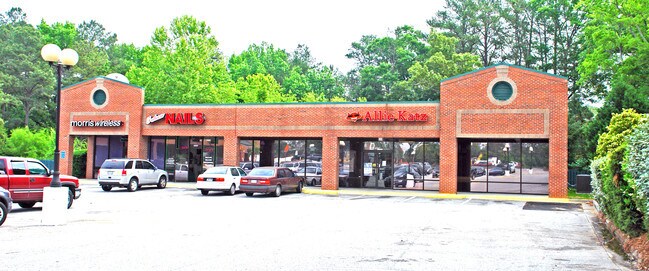
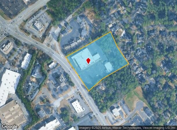
3637 Walton Way Ext
0230261000
Charles Blvd Assoc L
Commercialacreage
3629 WALTON WAY EXT
X
Richmond
13245C0105G
Georgia
2025
5.42 AC
2025
North Richmond County
010201
Augusta/Richmond County
45,592 SF
Augusta-Richmond County, GA-SC
DEMOGRAPHICS near 3637 Walton Way Ext
1 Mile
3 Mile
5 Mile
2024 Total Population
6,774
60,469
148,227
2029 Population
6,585
61,260
153,241
Pop Growth 2024-2029
(2.79%)
+ 1.31%
+ 3.38%
Average Age
40
39
40
2024 Total Households
3,305
27,287
62,803
HH Growth 2024-2029
(2.81%)
+ 0.64%
+ 2.65%
Median Household Inc
$75,498
$61,554
$57,844
Avg Household Size
2.00
2.20
2.30
2024 Avg HH Vehicles
2.00
2.00
2.00
Median Home Value
$236,218
$188,128
$186,165
Median Year Built
1987
1984
1982
Nearby Places
Map Layers
Map Styles
 Street
 Aerial
- Restaurants
- Banks
- Shops
- Fitness
- Groceries
PUBLIC TRANSPORTATION
AIRPORT
Augusta Regional at Bush Field
DRIVE
WALK
Distance
Augusta Regional at Bush Field
22 min
13.1 mi
Freight Ports
Georgia Ports - Savannah
DRIVE
WALK
Distance
Georgia Ports - Savannah
157 min
122.2 mi
Nearby Properties
Address
Land Use
TOTAL SIZE
Lot Size
Zoning
Address
Land Use
TOTAL SIZE
Lot Size
Zoning
371,617 SF
13.26 AC
B-2
Address
Land Use
TOTAL SIZE
Lot Size
Zoning
4,357 SF
34 AC
R-3B
Address
Land Use
TOTAL SIZE
Lot Size
Zoning
7,216 SF
53.27 AC
B-1 SPEX
Address
Land Use
TOTAL SIZE
Lot Size
Zoning
292,232 SF
39.73 AC
B-2
Address
Land Use
TOTAL SIZE
Lot Size
Zoning
5,541 SF
14.81 AC
B-2
Address
Land Use
TOTAL SIZE
Lot Size
Zoning
4,077 SF
20.88 AC
C-2;GEN CO
Address
Land Use
TOTAL SIZE
Lot Size
Zoning
5,480 SF
19.05 AC
R-3B
Address
Land Use
TOTAL SIZE
Lot Size
Zoning
3,680 SF
13.42 AC
B-2
Address
Land Use
TOTAL SIZE
Lot Size
Zoning
3,498 SF
12.61 AC
B-2
Address
Land Use
TOTAL SIZE
Lot Size
Zoning
36,755 SF
12.09 AC
B-2
Address
Land Use
TOTAL SIZE
Lot Size
Zoning
2,326 SF
21.90 AC
R-3B
Address
Land Use
TOTAL SIZE
Lot Size
Zoning
4,800 SF
19.81 AC
B-2
Address
Land Use
TOTAL SIZE
Lot Size
Zoning
61,236 SF
8.09 AC
R-3B
Address
Land Use
TOTAL SIZE
Lot Size
Zoning
952 SF
29 AC
A
Address
Land Use
TOTAL SIZE
Lot Size
Zoning
3,829 SF
35.30 AC
R-3B
Address
Land Use
TOTAL SIZE
Lot Size
Zoning
150,807 SF
16.91 AC
R-1A SPEX
Address
Land Use
TOTAL SIZE
Lot Size
Zoning
38,080 SF
19.19 AC
R-3B
Address
Land Use
TOTAL SIZE
Lot Size
Zoning
114,153 SF
12.91 AC
B-2
Address
Land Use
TOTAL SIZE
Lot Size
Zoning
66,300 SF
18.22 AC
B-1
Address
Land Use
TOTAL SIZE
Lot Size
Zoning
4,108 SF
14.12 AC
B-2
Address
Land Use
TOTAL SIZE
Lot Size
Zoning
1,782 SF
26.27 AC
R-3A
Address
Land Use
TOTAL SIZE
Lot Size
Zoning
640 SF
12.17 AC
B-1
Address
Land Use
TOTAL SIZE
Lot Size
Zoning
6,323 SF
25.49 AC
R-3C
Address
Land Use
TOTAL SIZE
Lot Size
Zoning
8,640 SF
13.15 AC
R-3B
Address
Land Use
TOTAL SIZE
Lot Size
Zoning
102,060 SF
45.63 AC
R-3B
Address
Land Use
TOTAL SIZE
Lot Size
Zoning
112,947 SF
14.91 AC
Address
Land Use
TOTAL SIZE
Lot Size
Zoning
72,381 SF
0.95 AC
Address
Land Use
TOTAL SIZE
Lot Size
Zoning
42,617 SF
40.26 AC
R-1_B-1
Address
Land Use
TOTAL SIZE
Lot Size
Zoning
2,757 SF
19.55 AC
B-2_R-1
Address
Land Use
TOTAL SIZE
Lot Size
Zoning
68,600 SF
20.94 AC
R-3A
The World's #1 Commercial Real Estate Marketplace
Connect with us
© 2025 CoStar Group
The information above has been obtained from sources believed reliable. While we do not doubt its accuracy we have not verified it and make no guarantee, warranty or representation about it. It is your responsibility to independently confirm its accuracy and completeness. Any projections, opinions, assumptions, or estimates used are for example only and do not represent the current or future performance of the property. The value of this transaction to you depends on tax and other factors which should be evaluated by your tax, financial, and legal advisors. You and your advisors should conduct a careful, independent investigation of the property to determine to your satisfaction the suitability of the property for your needs.