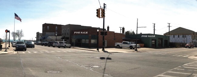
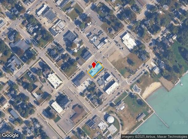
Property Record
36370 Main St, New Baltimore, MI 48047
NEARBY LISTINGS FOR SALE OR LEASE
-
-
View all New Baltimore listings for sale on LoopNet.com
Property Detail
36370 Main St
Detroit-Warren-Dearborn, MI
Map And Survey Of The Village Of Ashley
06-09-13-483-030
ORIGINAL TOWN (L40, P1 DEEDS); BLOCK 7, LOT 2 AND NW10 FT OF LOT 3 (AKA LAKE ST CLAIR MAP OF THE CITY OF ASHLEY)
Officebuilding
Macomb
X
Michigan
26147C0490E
2-3
2024
0.23 AC
2025
Groesbeck North
220002
Detroit
5,366 SF
DEMOGRAPHICS near 36370 Main St
1 Mile
3 Mile
5 Mile
2024 Total Population
5,136
27,928
61,470
2029 Population
5,062
27,827
61,412
Pop Growth 2024-2029
(1.44%)
(0.36%)
(0.09%)
Average Age
42
42
40
2024 Total Households
2,081
10,559
23,218
HH Growth 2024-2029
(1.25%)
(0.35%)
(0.05%)
Median Household Inc
$73,508
$90,273
$79,749
Avg Household Size
2.40
2.60
2.50
2024 Avg HH Vehicles
2.00
2.00
2.00
Median Home Value
$262,953
$271,890
$250,763
Median Year Built
1983
1993
1994
Nearby Places
Map Layers
Map Styles
 Street
 Aerial
- Restaurants
- Banks
- Shops
- Fitness
- Groceries
SALE & LEASE HISTORY
LISTING DATE
SALE/LEASE

Mar 30, 2018
For Sale
Nearby Properties
Address
Land Use
TOTAL SIZE
Lot Size
Zoning
Address
Land Use
TOTAL SIZE
Lot Size
Zoning
147,578 SF
12.84 AC
GC
Address
Land Use
TOTAL SIZE
Lot Size
Zoning
124,902 SF
11.38 AC
RM2 MU
Address
Land Use
TOTAL SIZE
Lot Size
Zoning
210,688 SF
20.13 AC
CG
Address
Land Use
TOTAL SIZE
Lot Size
Zoning
88,183 SF
27.97 AC
RM1 MU
Address
Land Use
TOTAL SIZE
Lot Size
Zoning
112,151 SF
9.31 AC
C3 GEN
Address
Land Use
TOTAL SIZE
Lot Size
Zoning
169,535 SF
12.20 AC
I
Address
Land Use
TOTAL SIZE
Lot Size
Zoning
276,497 SF
31.19 AC
I-1
Address
Land Use
TOTAL SIZE
Lot Size
Zoning
124,280 SF
11.50 AC
RM-1
Address
Land Use
TOTAL SIZE
Lot Size
Zoning
89,620 SF
17.89 AC
Address
Land Use
TOTAL SIZE
Lot Size
Zoning
7.70 AC
R1A RES
Address
Land Use
TOTAL SIZE
Lot Size
Zoning
60,123 SF
120 AC
I-2
Address
Land Use
TOTAL SIZE
Lot Size
Zoning
74,952 SF
6.05 AC
RM-2
Address
Land Use
TOTAL SIZE
Lot Size
Zoning
50,091 SF
4.80 AC
RM1 MU
Address
Land Use
TOTAL SIZE
Lot Size
Zoning
49,600 SF
14.50 AC
I-2
Address
Land Use
TOTAL SIZE
Lot Size
Zoning
22,140 SF
I
Address
Land Use
TOTAL SIZE
Lot Size
Zoning
30,240 SF
3.03 AC
GC
Address
Land Use
TOTAL SIZE
Lot Size
Zoning
8.66 AC
GC
Address
Land Use
TOTAL SIZE
Lot Size
Zoning
40,804 SF
3.53 AC
RM-1
Address
Land Use
TOTAL SIZE
Lot Size
Zoning
53,540 SF
7.99 AC
I
Address
Land Use
TOTAL SIZE
Lot Size
Zoning
7.93 AC
I-1
Address
Land Use
TOTAL SIZE
Lot Size
Zoning
17,880 SF
4.78 AC
I
Address
Land Use
TOTAL SIZE
Lot Size
Zoning
56,505 SF
I-1
Address
Land Use
TOTAL SIZE
Lot Size
Zoning
39,072 SF
2 AC
WF WAT
Address
Land Use
TOTAL SIZE
Lot Size
Zoning
48,639 SF
10.78 AC
C3 GEN
Address
Land Use
TOTAL SIZE
Lot Size
Zoning
27,314 SF
2.90 AC
C1 LOC
Address
Land Use
TOTAL SIZE
Lot Size
Zoning
36,560 SF
2.80 AC
I
Address
Land Use
TOTAL SIZE
Lot Size
Zoning
40,754 SF
10.78 AC
C3 GEN
Address
Land Use
TOTAL SIZE
Lot Size
Zoning
3.28 AC
R1A RES
Address
Land Use
TOTAL SIZE
Lot Size
Zoning
1,705 SF
40 AC
C1 LOC
Address
Land Use
TOTAL SIZE
Lot Size
Zoning
32,270 SF
1.91 AC
I
The World's #1 Commercial Real Estate Marketplace
Connect with us
© 2025 CoStar Group
The information above has been obtained from sources believed reliable. While we do not doubt its accuracy we have not verified it and make no guarantee, warranty or representation about it. It is your responsibility to independently confirm its accuracy and completeness. Any projections, opinions, assumptions, or estimates used are for example only and do not represent the current or future performance of the property. The value of this transaction to you depends on tax and other factors which should be evaluated by your tax, financial, and legal advisors. You and your advisors should conduct a careful, independent investigation of the property to determine to your satisfaction the suitability of the property for your needs.