Property Record
3638 W Baseline Rd, Laveen, AZ 85339
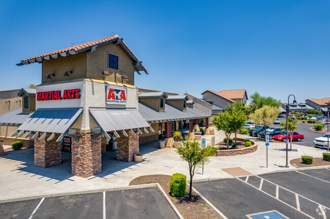

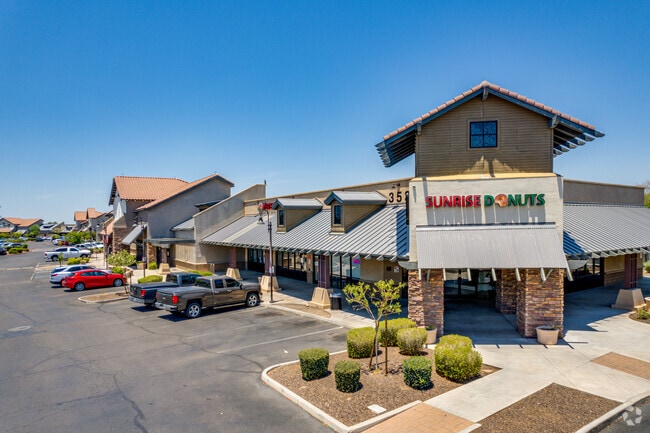

Property Detail
3638 W Baseline Rd
105-89-963
LAVEEN VILLAGE CENTER LOTS 1, 2 AND 3 REPLAT MCR 1276-02
Storebuilding
MARICOPA
R-43
Arizona
C and X Area of minimal flood hazard, usually depicted on FIRMs as above the 500-year flood level.
1
2025
12.13 AC
2025
Laveen
116619
Phoenix
103,111 SF
Phoenix-Mesa-Chandler, AZ
NEARBY LISTINGS FOR SALE OR LEASE
DEMOGRAPHICS near 3638 W Baseline Rd
1 mile
3 mile
5 mile
2025 Total Population
13,934
82,096
177,056
2030 Population
14,485
86,147
185,839
Pop Growth 2025-2030
+ 3.95%
+ 4.93%
+ 4.96%
Average Age
34
35
35
2025 Total Households
3,893
22,950
50,078
HH Growth 2025-2030
+ 4.01%
+ 5.06%
+ 5.05%
Median Household Inc
$94,786
$94,130
$80,345
Avg Household Size
3.50
3.50
3.40
2025 Avg HH Vehicles
2.00
2.00
2.00
Median Home Value
$439,292
$427,151
$407,165
Median Year Built
2004
2005
2002
Nearby Places
Map Layers
Map Styles
 Street
 Aerial
Layers
 Traffic
 Biking
Places
Listings with unknown addresses are not visible on the map
- Restaurants
- Banks
- Shops
- Fitness
- Groceries
PUBLIC TRANSPORTATION
AIRPORT
Phoenix Sky Harbor International
Drive
Walk
Distance
Phoenix Sky Harbor International
24 min
12.5 mi
Phoenix-Mesa Gateway
Drive
Walk
Distance
Phoenix-Mesa Gateway
52 min
34.3 mi
Nearby Properties
Address
Land Use
TOTAL SIZE
Lot Size
Zoning
Address
Land Use
TOTAL SIZE
Lot Size
Zoning
182,984 SF
146.12 AC
I-1
Address
Land Use
TOTAL SIZE
Lot Size
Zoning
33.15 AC
Address
Land Use
TOTAL SIZE
Lot Size
Zoning
20,430 SF
24.57 AC
I-1
Address
Land Use
TOTAL SIZE
Lot Size
Zoning
392,945 SF
47.26 AC
R-43AG
Address
Land Use
TOTAL SIZE
Lot Size
Zoning
47,597 SF
22.74 AC
R-43
Address
Land Use
TOTAL SIZE
Lot Size
Zoning
367,953 SF
38.18 AC
R-43AG
Address
Land Use
TOTAL SIZE
Lot Size
Zoning
398,815 SF
12.72 AC
C2
Address
Land Use
TOTAL SIZE
Lot Size
Zoning
1,875 SF
7.89 AC
I-1
Address
Land Use
TOTAL SIZE
Lot Size
Zoning
70,951 SF
336.40 AC
R-43AG
Address
Land Use
TOTAL SIZE
Lot Size
Zoning
233,156 SF
15.77 AC
R3A
Address
Land Use
TOTAL SIZE
Lot Size
Zoning
273,812 SF
32.75 AC
I-1
Address
Land Use
TOTAL SIZE
Lot Size
Zoning
93,310 SF
9.16 AC
R-6
Address
Land Use
TOTAL SIZE
Lot Size
Zoning
95,854 SF
15.11 AC
R-43AG
Address
Land Use
TOTAL SIZE
Lot Size
Zoning
91,949 SF
19.14 AC
R-43
Address
Land Use
TOTAL SIZE
Lot Size
Zoning
9,222 SF
171.26 AC
I-1
Address
Land Use
TOTAL SIZE
Lot Size
Zoning
219,555 SF
21.25 AC
C2
Address
Land Use
TOTAL SIZE
Lot Size
Zoning
91,063 SF
12 AC
R-43AG
Address
Land Use
TOTAL SIZE
Lot Size
Zoning
105,401 SF
13.82 AC
Address
Land Use
TOTAL SIZE
Lot Size
Zoning
101,619 SF
13.71 AC
R-8
Address
Land Use
TOTAL SIZE
Lot Size
Zoning
139,410 SF
14.41 AC
C-C
Address
Land Use
TOTAL SIZE
Lot Size
Zoning
92,917 SF
14.54 AC
Address
Land Use
TOTAL SIZE
Lot Size
Zoning
164,212 SF
11.81 AC
R-8
Address
Land Use
TOTAL SIZE
Lot Size
Zoning
120,280 SF
12.39 AC
R3
Address
Land Use
TOTAL SIZE
Lot Size
Zoning
8,880 SF
1.99 AC
I-2
Address
Land Use
TOTAL SIZE
Lot Size
Zoning
39,000 SF
3.92 AC
C-C
Address
Land Use
TOTAL SIZE
Lot Size
Zoning
58,603 SF
12.15 AC
R-43AG
Address
Land Use
TOTAL SIZE
Lot Size
Zoning
64,031 SF
14.68 AC
R-43AG
Address
Land Use
TOTAL SIZE
Lot Size
Zoning
102,085 SF
12.32 AC
C-C
Address
Land Use
TOTAL SIZE
Lot Size
Zoning
75,877 SF
7.91 AC
R-43AG
The World's #1 Commercial Real Estate Marketplace
Connect with us
© 2026 CoStar Group
The information above has been obtained from sources believed reliable. While we do not doubt its accuracy we have not verified it and make no guarantee, warranty or representation about it. It is your responsibility to independently confirm its accuracy and completeness. Any projections, opinions, assumptions, or estimates used are for example only and do not represent the current or future performance of the property. The value of this transaction to you depends on tax and other factors which should be evaluated by your tax, financial, and legal advisors. You and your advisors should conduct a careful, independent investigation of the property to determine to your satisfaction the suitability of the property for your needs.