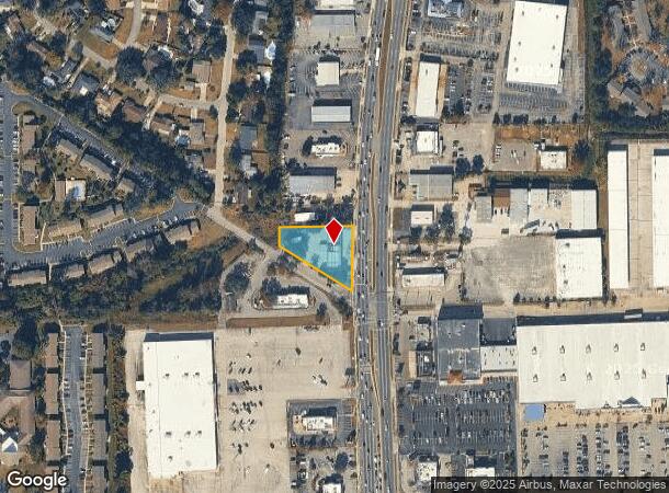
Property Record
364 Blanding Blvd, Orange Park, FL 32073
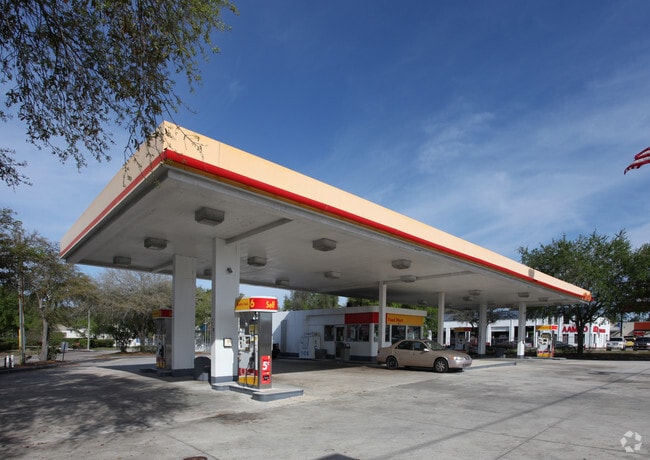
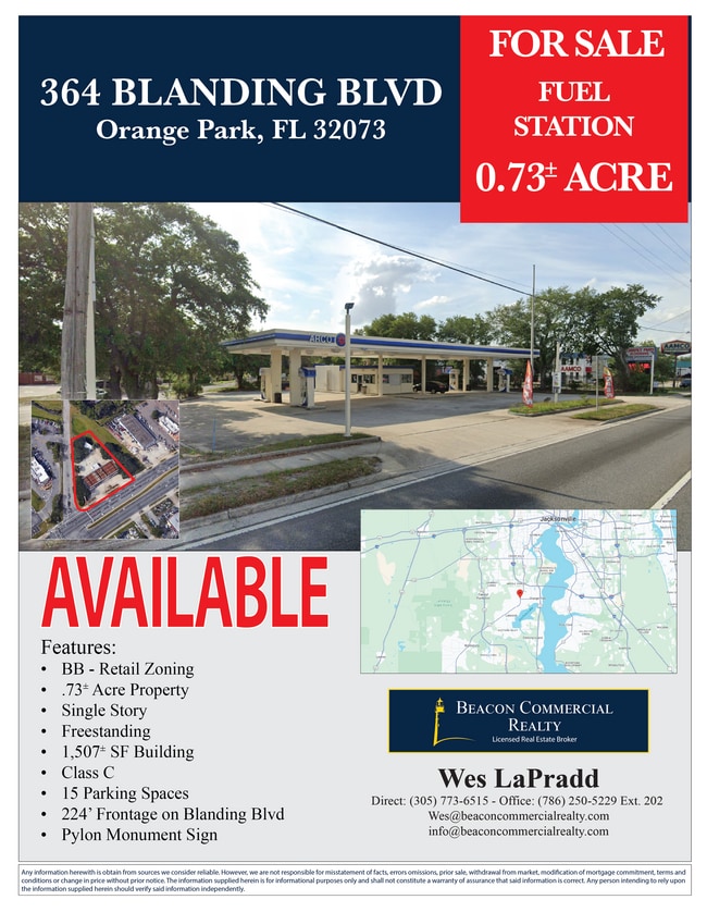
This Property Is For Sale
NEARBY LISTINGS FOR SALE OR LEASE
Property Detail
364 Blanding Blvd
Jacksonville, FL
Ridgewood
12-04-25-020293-007-00
PT LOT 4 RIDGEWOOD SEC 9 AS REC OR 4432 PG 1764
Storemultistory
Clay
X
Florida
12019C0090E
4
2024
0.73 AC
2025
Orange Park/Clay County
030305
Jacksonville (Florida)
1,466 SF
DEMOGRAPHICS near 364 Blanding Blvd
1 Mile
3 Mile
5 Mile
2024 Total Population
10,517
65,021
144,523
2029 Population
11,376
70,130
154,982
Pop Growth 2024-2029
+ 8.17%
+ 7.86%
+ 7.24%
Average Age
42
41
40
2024 Total Households
3,928
25,440
53,623
HH Growth 2024-2029
+ 8.25%
+ 7.90%
+ 7.33%
Median Household Inc
$67,325
$64,686
$73,235
Avg Household Size
2.60
2.50
2.60
2024 Avg HH Vehicles
2.00
2.00
2.00
Median Home Value
$191,446
$221,994
$233,820
Median Year Built
1975
1985
1990
Nearby Places
- Restaurants
- Banks
- Shops
- Fitness
- Groceries
PUBLIC TRANSPORTATION
AIRPORT
Jacksonville International
DRIVE
WALK
Distance
Jacksonville International
41 min
28.2 mi
Freight Ports
Jacksonville Port
DRIVE
WALK
Distance
Jacksonville Port
34 min
22.0 mi
Nearby Properties
Address
Land Use
TOTAL SIZE
Lot Size
Zoning
Address
Land Use
TOTAL SIZE
Lot Size
Zoning
721,413 SF
46.72 AC
REBS
Address
Land Use
TOTAL SIZE
Lot Size
Zoning
446,722 SF
13.26 AC
PUD
Address
Land Use
TOTAL SIZE
Lot Size
Zoning
336,253 SF
30.19 AC
PUD
Address
Land Use
TOTAL SIZE
Lot Size
Zoning
270,088 SF
18.50 AC
PUD
Address
Land Use
TOTAL SIZE
Lot Size
Zoning
411,303 SF
26.71 AC
RMD-C
Address
Land Use
TOTAL SIZE
Lot Size
Zoning
250,798 SF
16.84 AC
PUD
Address
Land Use
TOTAL SIZE
Lot Size
Zoning
246,982 SF
24.84 AC
PUD
Address
Land Use
TOTAL SIZE
Lot Size
Zoning
238,713 SF
53.48 AC
BB
Address
Land Use
TOTAL SIZE
Lot Size
Zoning
227,234 SF
19.99 AC
RD-4
Address
Land Use
TOTAL SIZE
Lot Size
Zoning
281,440 SF
17.01 AC
Address
Land Use
TOTAL SIZE
Lot Size
Zoning
355,124 SF
18.80 AC
PUD
Address
Land Use
TOTAL SIZE
Lot Size
Zoning
278,173 SF
27.85 AC
Address
Land Use
TOTAL SIZE
Lot Size
Zoning
296,311 SF
20.07 AC
Address
Land Use
TOTAL SIZE
Lot Size
Zoning
290,919 SF
18.75 AC
PUD
Address
Land Use
TOTAL SIZE
Lot Size
Zoning
380,002 SF
60.91 AC
RG-1
Address
Land Use
TOTAL SIZE
Lot Size
Zoning
234,646 SF
18.97 AC
Address
Land Use
TOTAL SIZE
Lot Size
Zoning
348,247 SF
31.85 AC
PUD
Address
Land Use
TOTAL SIZE
Lot Size
Zoning
244,004 SF
24.97 AC
PUD
Address
Land Use
TOTAL SIZE
Lot Size
Zoning
281,174 SF
25.34 AC
PUD
Address
Land Use
TOTAL SIZE
Lot Size
Zoning
92,193 SF
20.65 AC
PUD
Address
Land Use
TOTAL SIZE
Lot Size
Zoning
33,237 SF
33.08 AC
Address
Land Use
TOTAL SIZE
Lot Size
Zoning
207,472 SF
13.39 AC
RD-4
Address
Land Use
TOTAL SIZE
Lot Size
Zoning
172,568 SF
13.15 AC
Address
Land Use
TOTAL SIZE
Lot Size
Zoning
188,578 SF
13.44 AC
RMD-D
Address
Land Use
TOTAL SIZE
Lot Size
Zoning
98,675 SF
24.30 AC
Address
Land Use
TOTAL SIZE
Lot Size
Zoning
207,571 SF
16.06 AC
PUD
Address
Land Use
TOTAL SIZE
Lot Size
Zoning
168,475 SF
9.38 AC
RD-4
Address
Land Use
TOTAL SIZE
Lot Size
Zoning
173,163 SF
18.32 AC
BSC
Address
Land Use
TOTAL SIZE
Lot Size
Zoning
159,684 SF
6.48 AC
Address
Land Use
TOTAL SIZE
Lot Size
Zoning
215,983 SF
18.80 AC
CCG-1
The World's #1 Commercial Real Estate Marketplace
Connect with us
© 2025 CoStar Group
The information above has been obtained from sources believed reliable. While we do not doubt its accuracy we have not verified it and make no guarantee, warranty or representation about it. It is your responsibility to independently confirm its accuracy and completeness. Any projections, opinions, assumptions, or estimates used are for example only and do not represent the current or future performance of the property. The value of this transaction to you depends on tax and other factors which should be evaluated by your tax, financial, and legal advisors. You and your advisors should conduct a careful, independent investigation of the property to determine to your satisfaction the suitability of the property for your needs.