Property Record
3640 N Carl G Rose Hwy, Hernando, FL 34442


NEARBY LISTINGS FOR SALE OR LEASE
-
-
View all Hernando listings for sale on LoopNet.com
Property Detail
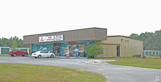
3640 N Carl G Rose Hwy
19E-18S-23-0000-14300-00A1
Unrec Tracts In 23-18S-19E
Warehouse
COM AT THE SW COR OF NW1/4 OF NE1/4 SEC 23-18-19 TH N 0D 18M 36S E AL THE QUARTER SEC LINE 1326.50 FT TO THE N QUARTER SEC COR OF SD SEC 23 TH S 89D 28M 42S E AL THE N LN OF SD SEC 23 326.28 FT TO THE POB TH CONT S 89D 28M 42S E 237 FT TO THE W R/W L
AE
Citrus
12017C0217D
Florida
2024
4.51 AC
2025
Florida Central North Area
450106
Other Market Areas
53,360 SF
Homosassa Springs, FL
DEMOGRAPHICS near 3640 N Carl G Rose Hwy
1 Mile
3 Mile
5 Mile
2024 Total Population
2,158
11,090
35,157
2029 Population
2,487
12,664
40,045
Pop Growth 2024-2029
+ 15.25%
+ 14.19%
+ 13.90%
Average Age
55
52
52
2024 Total Households
1,070
5,106
16,103
HH Growth 2024-2029
+ 15.05%
+ 14.02%
+ 13.69%
Median Household Inc
$43,473
$46,517
$45,901
Avg Household Size
1.90
2.10
2.10
2024 Avg HH Vehicles
2.00
2.00
2.00
Median Home Value
$199,090
$194,476
$199,367
Median Year Built
1989
1991
1989
Nearby Places
Map Layers
Map Styles
 Street
 Aerial
- Restaurants
- Banks
- Shops
- Fitness
- Groceries
Nearby Properties
Address
Land Use
TOTAL SIZE
Lot Size
Zoning
Address
Land Use
TOTAL SIZE
Lot Size
Zoning
84,611 SF
33.22 AC
PSI
Address
Land Use
TOTAL SIZE
Lot Size
Zoning
119,399 SF
4.77 AC
GNC
Address
Land Use
TOTAL SIZE
Lot Size
Zoning
40,648 SF
4.85 AC
GNC
Address
Land Use
TOTAL SIZE
Lot Size
Zoning
18,114 SF
9.11 AC
GNC
Address
Land Use
TOTAL SIZE
Lot Size
Zoning
24,600 SF
1.64 AC
LDR
Address
Land Use
TOTAL SIZE
Lot Size
Zoning
46,900 SF
2.04 AC
GNC
Address
Land Use
TOTAL SIZE
Lot Size
Zoning
42,640 SF
5.04 AC
GNC
Address
Land Use
TOTAL SIZE
Lot Size
Zoning
27,692 SF
4.05 AC
PSI
Address
Land Use
TOTAL SIZE
Lot Size
Zoning
17,008 SF
5.07 AC
LDRMH
Address
Land Use
TOTAL SIZE
Lot Size
Zoning
28,222 SF
15.81 AC
LDRMH
Address
Land Use
TOTAL SIZE
Lot Size
Zoning
28,078 SF
3.48 AC
GNC
Address
Land Use
TOTAL SIZE
Lot Size
Zoning
3,914 SF
5.02 AC
CLR
Address
Land Use
TOTAL SIZE
Lot Size
Zoning
31,200 SF
3.58 AC
GNC
Address
Land Use
TOTAL SIZE
Lot Size
Zoning
8,650 SF
3.55 AC
GNC
Address
Land Use
TOTAL SIZE
Lot Size
Zoning
28,006 SF
2.05 AC
GNC
Address
Land Use
TOTAL SIZE
Lot Size
Zoning
24.12 AC
RVP
Address
Land Use
TOTAL SIZE
Lot Size
Zoning
29,130 SF
3.27 AC
GNC
Address
Land Use
TOTAL SIZE
Lot Size
Zoning
11,384 SF
6.96 AC
GNC
Address
Land Use
TOTAL SIZE
Lot Size
Zoning
9,100 SF
2.21 AC
GNC
Address
Land Use
TOTAL SIZE
Lot Size
Zoning
11,812 SF
1.06 AC
GNC
Address
Land Use
TOTAL SIZE
Lot Size
Zoning
8,574 SF
1.13 AC
MDRMH
Address
Land Use
TOTAL SIZE
Lot Size
Zoning
9,230 SF
1.52 AC
PDR
Address
Land Use
TOTAL SIZE
Lot Size
Zoning
1,200 SF
43.89 AC
PSI
Address
Land Use
TOTAL SIZE
Lot Size
Zoning
9,780 SF
11.86 AC
CL
Address
Land Use
TOTAL SIZE
Lot Size
Zoning
17,664 SF
2.02 AC
GNC
Address
Land Use
TOTAL SIZE
Lot Size
Zoning
20,038 SF
4.78 AC
CLR
Address
Land Use
TOTAL SIZE
Lot Size
Zoning
18,666 SF
1.87 AC
GNC
Address
Land Use
TOTAL SIZE
Lot Size
Zoning
21,120 SF
1.75 AC
IND
Address
Land Use
TOTAL SIZE
Lot Size
Zoning
48,545 SF
7.22 AC
HDR
The World's #1 Commercial Real Estate Marketplace
Connect with us
© 2025 CoStar Group
The information above has been obtained from sources believed reliable. While we do not doubt its accuracy we have not verified it and make no guarantee, warranty or representation about it. It is your responsibility to independently confirm its accuracy and completeness. Any projections, opinions, assumptions, or estimates used are for example only and do not represent the current or future performance of the property. The value of this transaction to you depends on tax and other factors which should be evaluated by your tax, financial, and legal advisors. You and your advisors should conduct a careful, independent investigation of the property to determine to your satisfaction the suitability of the property for your needs.