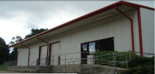
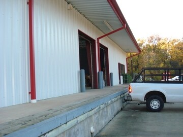
Property Record
3640 Thomas St, Memphis, TN 38127

NEARBY LISTINGS FOR SALE OR LEASE
-
-
View all Memphis listings for sale on LoopNet.com
Property Detail
3640 Thomas St
06-9062-0-0033
The Illinois Central Railroad
Religious
PRIOR REF:18110215
X
Shelby
05035C0375E
Tennessee
0
2.52 AC
2025
Northwest
009901
Memphis
6,000 SF
Memphis, TN-MS-AR
DEMOGRAPHICS near 3640 Thomas St
1 Mile
3 Mile
5 Mile
2024 Total Population
8,120
37,714
88,111
2029 Population
8,177
37,832
88,517
Pop Growth 2024-2029
+ 0.70%
+ 0.31%
+ 0.46%
Average Age
33
35
37
2024 Total Households
2,927
13,338
34,611
HH Growth 2024-2029
+ 0.65%
+ 0.22%
+ 0.34%
Median Household Inc
$29,787
$35,959
$38,505
Avg Household Size
2.70
2.70
2.50
2024 Avg HH Vehicles
1.00
2.00
1.00
Median Home Value
$64,211
$68,697
$89,567
Median Year Built
1963
1965
1967
Nearby Places
Map Layers
Map Styles
 Street
 Aerial
- Restaurants
- Banks
- Shops
- Fitness
- Groceries
PUBLIC TRANSPORTATION
COMMUTER RAIL
Central Station (Riverfront Loop - Memphis Area Transit Authority Trolley (MataTrolley))
DRIVE
WALK
Distance
Central Station (Riverfront Loop - Memphis Area Transit Authority Trolley (MataTrolley))
12 min
7.4 mi
AIRPORT
Memphis International
DRIVE
WALK
Distance
Memphis International
27 min
15.2 mi
Nearby Properties
Address
Land Use
TOTAL SIZE
Lot Size
Zoning
Address
Land Use
TOTAL SIZE
Lot Size
Zoning
1,913,224 SF
78.98 AC
IH
Address
Land Use
TOTAL SIZE
Lot Size
Zoning
2,912 SF
100 AC
CA
Address
Land Use
TOTAL SIZE
Lot Size
Zoning
111,016 SF
6.90 AC
CMU-1
Address
Land Use
TOTAL SIZE
Lot Size
Zoning
92,798 SF
12.66 AC
RU-3
Address
Land Use
TOTAL SIZE
Lot Size
Zoning
56,620 SF
25.08 AC
R-6
Address
Land Use
TOTAL SIZE
Lot Size
Zoning
32,116 SF
7.61 AC
R-6
Address
Land Use
TOTAL SIZE
Lot Size
Zoning
19,013 SF
3.51 AC
RU-3
Address
Land Use
TOTAL SIZE
Lot Size
Zoning
18,492 SF
8.35 AC
R-6
Address
Land Use
TOTAL SIZE
Lot Size
Zoning
53,176 SF
12.57 AC
RU-3
Address
Land Use
TOTAL SIZE
Lot Size
Zoning
47,756 SF
9.94 AC
RU-3
Address
Land Use
TOTAL SIZE
Lot Size
Zoning
35,890 SF
10.53 AC
RU-3
Address
Land Use
TOTAL SIZE
Lot Size
Zoning
10.26 AC
R-10
Address
Land Use
TOTAL SIZE
Lot Size
Zoning
39,628 SF
8.81 AC
RU-3
Address
Land Use
TOTAL SIZE
Lot Size
Zoning
22,925 SF
13.53 AC
RU-3
Address
Land Use
TOTAL SIZE
Lot Size
Zoning
48,194 SF
5.49 AC
R-6
Address
Land Use
TOTAL SIZE
Lot Size
Zoning
51,253 SF
17.50 AC
RU-3
Address
Land Use
TOTAL SIZE
Lot Size
Zoning
37,092 SF
4.30 AC
RU-3
Address
Land Use
TOTAL SIZE
Lot Size
Zoning
236,244 SF
11.24 AC
EMP
Address
Land Use
TOTAL SIZE
Lot Size
Zoning
84,851 SF
11.25 AC
CMU-2
Address
Land Use
TOTAL SIZE
Lot Size
Zoning
62,008 SF
6.45 AC
RU-3
Address
Land Use
TOTAL SIZE
Lot Size
Zoning
49,200 SF
3.38 AC
CMU-2
Address
Land Use
TOTAL SIZE
Lot Size
Zoning
30.25 AC
IH
Address
Land Use
TOTAL SIZE
Lot Size
Zoning
35,562 SF
1.45 AC
CMU-1
Address
Land Use
TOTAL SIZE
Lot Size
Zoning
56,185 SF
3.53 AC
CMU-3
Address
Land Use
TOTAL SIZE
Lot Size
Zoning
33,590 SF
10.46 AC
RU-3
Address
Land Use
TOTAL SIZE
Lot Size
Zoning
82,550 SF
7.84 AC
IH
Address
Land Use
TOTAL SIZE
Lot Size
Zoning
16,545 SF
3.25 AC
CMU-2
Address
Land Use
TOTAL SIZE
Lot Size
Zoning
64,810 SF
6.68 AC
CMU-2
Address
Land Use
TOTAL SIZE
Lot Size
Zoning
40,320 SF
6.83 AC
RU-3
Address
Land Use
TOTAL SIZE
Lot Size
Zoning
14,850 SF
1.53 AC
CMU-1
The World's #1 Commercial Real Estate Marketplace
Connect with us
© 2026 CoStar Group
The information above has been obtained from sources believed reliable. While we do not doubt its accuracy we have not verified it and make no guarantee, warranty or representation about it. It is your responsibility to independently confirm its accuracy and completeness. Any projections, opinions, assumptions, or estimates used are for example only and do not represent the current or future performance of the property. The value of this transaction to you depends on tax and other factors which should be evaluated by your tax, financial, and legal advisors. You and your advisors should conduct a careful, independent investigation of the property to determine to your satisfaction the suitability of the property for your needs.