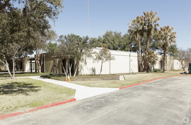
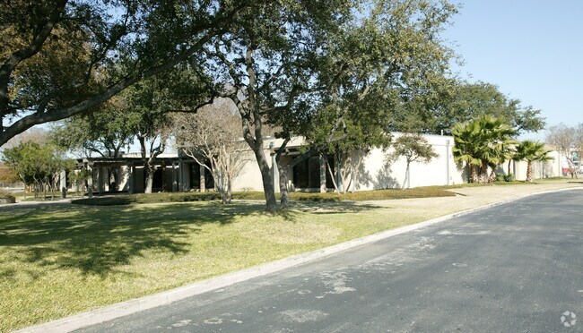
Property Record
3642 E Houston St, San Antonio, TX 78219
NEARBY LISTINGS FOR SALE OR LEASE
Property Detail
3642 E Houston St
San Antonio-New Braunfels, TX
Conv A/S Code
10234-000-0150
NCB 10234 BLK LOT 15 EXC N IRR 20.5 FT 2012 LEGAL DESC CHG PER DEED 15009/1911
Officebuilding
Bexar
AE
Texas
48029C0420G
15
0
2.39 AC
2025
Northeast
131000
San Antonio
36,833 SF
DEMOGRAPHICS near 3642 E Houston St
1 Mile
3 Mile
5 Mile
2024 Total Population
9,555
81,875
255,679
2029 Population
10,380
88,286
274,917
Pop Growth 2024-2029
+ 8.63%
+ 7.83%
+ 7.52%
Average Age
35
35
37
2024 Total Households
3,274
27,284
94,886
HH Growth 2024-2029
+ 8.67%
+ 7.99%
+ 7.89%
Median Household Inc
$34,017
$37,382
$47,191
Avg Household Size
2.80
2.80
2.50
2024 Avg HH Vehicles
2.00
2.00
2.00
Median Home Value
$83,642
$138,926
$175,422
Median Year Built
1967
1963
1969
Nearby Places
Map Layers
Map Styles
 Street
 Aerial
- Restaurants
- Banks
- Shops
- Fitness
- Groceries
PUBLIC TRANSPORTATION
COMMUTER RAIL
San Antonio Amtrak Station (Sunset Limited - Amtrak, Texas Eagle - Amtrak)
DRIVE
WALK
Distance
San Antonio Amtrak Station (Sunset Limited - Amtrak, Texas Eagle - Amtrak)
6 min
3.5 mi
AIRPORT
San Antonio International
DRIVE
WALK
Distance
San Antonio International
16 min
10.8 mi
Freight Ports
Calhoun Port
DRIVE
WALK
Distance
Calhoun Port
174 min
143.2 mi
Nearby Properties
Address
Land Use
TOTAL SIZE
Lot Size
Zoning
Address
Land Use
TOTAL SIZE
Lot Size
Zoning
2,544.56 AC
Address
Land Use
TOTAL SIZE
Lot Size
Zoning
397,806 SF
15.08 AC
Address
Land Use
TOTAL SIZE
Lot Size
Zoning
359,459 SF
15.81 AC
Address
Land Use
TOTAL SIZE
Lot Size
Zoning
202,609 SF
3.25 AC
Address
Land Use
TOTAL SIZE
Lot Size
Zoning
71,253 SF
25.52 AC
Address
Land Use
TOTAL SIZE
Lot Size
Zoning
35.76 AC
Address
Land Use
TOTAL SIZE
Lot Size
Zoning
139,410 SF
35.75 AC
Address
Land Use
TOTAL SIZE
Lot Size
Zoning
387,440 SF
27.71 AC
Address
Land Use
TOTAL SIZE
Lot Size
Zoning
110,252 SF
20.04 AC
Address
Land Use
TOTAL SIZE
Lot Size
Zoning
300,987 SF
29.07 AC
Address
Land Use
TOTAL SIZE
Lot Size
Zoning
33.77 AC
Address
Land Use
TOTAL SIZE
Lot Size
Zoning
208,494 SF
9.63 AC
Address
Land Use
TOTAL SIZE
Lot Size
Zoning
300,555 SF
29.35 AC
Address
Land Use
TOTAL SIZE
Lot Size
Zoning
280,365 SF
17.72 AC
Address
Land Use
TOTAL SIZE
Lot Size
Zoning
221,760 SF
7.22 AC
Address
Land Use
TOTAL SIZE
Lot Size
Zoning
306,000 SF
20.23 AC
Address
Land Use
TOTAL SIZE
Lot Size
Zoning
25,164 SF
13.31 AC
Address
Land Use
TOTAL SIZE
Lot Size
Zoning
101,517 SF
13.04 AC
Address
Land Use
TOTAL SIZE
Lot Size
Zoning
224,840 SF
17.27 AC
Address
Land Use
TOTAL SIZE
Lot Size
Zoning
199,280 SF
11.50 AC
Address
Land Use
TOTAL SIZE
Lot Size
Zoning
362,280 SF
17.84 AC
Address
Land Use
TOTAL SIZE
Lot Size
Zoning
68,055 SF
18.06 AC
Address
Land Use
TOTAL SIZE
Lot Size
Zoning
12.55 AC
Address
Land Use
TOTAL SIZE
Lot Size
Zoning
99.85 AC
Address
Land Use
TOTAL SIZE
Lot Size
Zoning
341,546 SF
26.84 AC
Address
Land Use
TOTAL SIZE
Lot Size
Zoning
161,880 SF
12.33 AC
Address
Land Use
TOTAL SIZE
Lot Size
Zoning
189,620 SF
12.62 AC
Address
Land Use
TOTAL SIZE
Lot Size
Zoning
201,672 SF
12.48 AC
Address
Land Use
TOTAL SIZE
Lot Size
Zoning
296,542 SF
26.32 AC
Address
Land Use
TOTAL SIZE
Lot Size
Zoning
44,800 SF
61.44 AC
The World's #1 Commercial Real Estate Marketplace
Connect with us
© 2025 CoStar Group
The information above has been obtained from sources believed reliable. While we do not doubt its accuracy we have not verified it and make no guarantee, warranty or representation about it. It is your responsibility to independently confirm its accuracy and completeness. Any projections, opinions, assumptions, or estimates used are for example only and do not represent the current or future performance of the property. The value of this transaction to you depends on tax and other factors which should be evaluated by your tax, financial, and legal advisors. You and your advisors should conduct a careful, independent investigation of the property to determine to your satisfaction the suitability of the property for your needs.