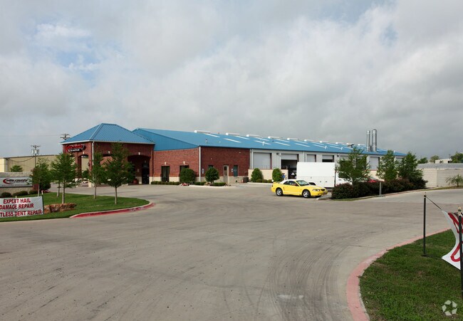
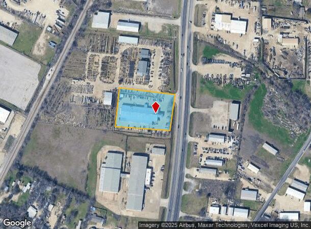
Property Record
3643 N Highway 77, Waxahachie, TX 75165

NEARBY LISTINGS FOR SALE OR LEASE
Property Detail
3643 N Highway 77
Dallas-Fort Worth-Arlington, TX
Go Green Addn
241035
2 A GO GREEN ADDN 2 ACRES
Commercialnec
Ellis
X
Texas
48139C0180G
2
2024
2 AC
2025
Southwest Outlying
060219
Dallas/Ft Worth
19,561 SF
DEMOGRAPHICS near 3643 N Highway 77
1 Mile
3 Mile
5 Mile
2024 Total Population
2,025
13,882
74,424
2029 Population
2,512
17,352
94,166
Pop Growth 2024-2029
+ 24.05%
+ 25.00%
+ 26.53%
Average Age
40
39
37
2024 Total Households
687
4,710
25,433
HH Growth 2024-2029
+ 24.45%
+ 25.24%
+ 26.75%
Median Household Inc
$127,296
$111,679
$103,752
Avg Household Size
2.90
2.90
2.90
2024 Avg HH Vehicles
2.00
2.00
2.00
Median Home Value
$312,305
$281,374
$281,629
Median Year Built
1997
2001
2003
Nearby Places
Map Layers
Map Styles
 Street
 Aerial
- Restaurants
- Banks
- Shops
- Fitness
- Groceries
PUBLIC TRANSPORTATION
AIRPORT
Dallas Love Field
DRIVE
WALK
Distance
Dallas Love Field
38 min
27.5 mi
Freight Ports
Port of Shreveport
DRIVE
WALK
Distance
Port of Shreveport
224 min
208.6 mi
SALE & LEASE HISTORY
LISTING DATE
SALE/LEASE

Mar 29, 2022
For Sale
Nearby Properties
Address
Land Use
TOTAL SIZE
Lot Size
Zoning
Address
Land Use
TOTAL SIZE
Lot Size
Zoning
364,814 SF
105.96 AC
Address
Land Use
TOTAL SIZE
Lot Size
Zoning
146,074 SF
42.83 AC
Address
Land Use
TOTAL SIZE
Lot Size
Zoning
281,216 SF
75.37 AC
Address
Land Use
TOTAL SIZE
Lot Size
Zoning
675,375 SF
59.26 AC
Address
Land Use
TOTAL SIZE
Lot Size
Zoning
413,050 SF
54.30 AC
Address
Land Use
TOTAL SIZE
Lot Size
Zoning
326,740 SF
23.01 AC
Address
Land Use
TOTAL SIZE
Lot Size
Zoning
352,350 SF
18.78 AC
Address
Land Use
TOTAL SIZE
Lot Size
Zoning
568,234 SF
65.79 AC
Address
Land Use
TOTAL SIZE
Lot Size
Zoning
92,860 SF
26.02 AC
Address
Land Use
TOTAL SIZE
Lot Size
Zoning
41,390 SF
90.38 AC
Address
Land Use
TOTAL SIZE
Lot Size
Zoning
104,885 SF
8 AC
Address
Land Use
TOTAL SIZE
Lot Size
Zoning
60,041 SF
6.76 AC
Address
Land Use
TOTAL SIZE
Lot Size
Zoning
871,497 SF
134.08 AC
Address
Land Use
TOTAL SIZE
Lot Size
Zoning
71,124 SF
10.72 AC
Address
Land Use
TOTAL SIZE
Lot Size
Zoning
62,126 SF
16.85 AC
Address
Land Use
TOTAL SIZE
Lot Size
Zoning
131,480 SF
7.30 AC
Address
Land Use
TOTAL SIZE
Lot Size
Zoning
68,150 SF
51.99 AC
Address
Land Use
TOTAL SIZE
Lot Size
Zoning
91,204 SF
5.04 AC
Address
Land Use
TOTAL SIZE
Lot Size
Zoning
77,212 SF
28.59 AC
Address
Land Use
TOTAL SIZE
Lot Size
Zoning
169,000 SF
31.43 AC
Address
Land Use
TOTAL SIZE
Lot Size
Zoning
41,025 SF
21.40 AC
Address
Land Use
TOTAL SIZE
Lot Size
Zoning
78,797 SF
2.95 AC
Address
Land Use
TOTAL SIZE
Lot Size
Zoning
181,425 SF
38.96 AC
Address
Land Use
TOTAL SIZE
Lot Size
Zoning
5,273 SF
71.81 AC
Address
Land Use
TOTAL SIZE
Lot Size
Zoning
17,625 SF
6.91 AC
Address
Land Use
TOTAL SIZE
Lot Size
Zoning
28,284 SF
2.47 AC
Address
Land Use
TOTAL SIZE
Lot Size
Zoning
157,100 SF
28.73 AC
Address
Land Use
TOTAL SIZE
Lot Size
Zoning
68,464 SF
16 AC
Address
Land Use
TOTAL SIZE
Lot Size
Zoning
64,235 SF
3.81 AC
Address
Land Use
TOTAL SIZE
Lot Size
Zoning
163,345 SF
9.93 AC
The World's #1 Commercial Real Estate Marketplace
Connect with us
© 2025 CoStar Group
The information above has been obtained from sources believed reliable. While we do not doubt its accuracy we have not verified it and make no guarantee, warranty or representation about it. It is your responsibility to independently confirm its accuracy and completeness. Any projections, opinions, assumptions, or estimates used are for example only and do not represent the current or future performance of the property. The value of this transaction to you depends on tax and other factors which should be evaluated by your tax, financial, and legal advisors. You and your advisors should conduct a careful, independent investigation of the property to determine to your satisfaction the suitability of the property for your needs.