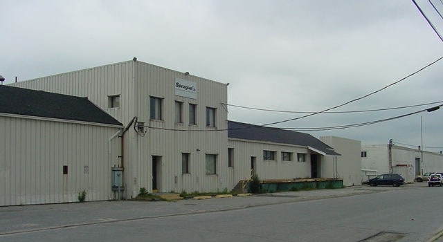
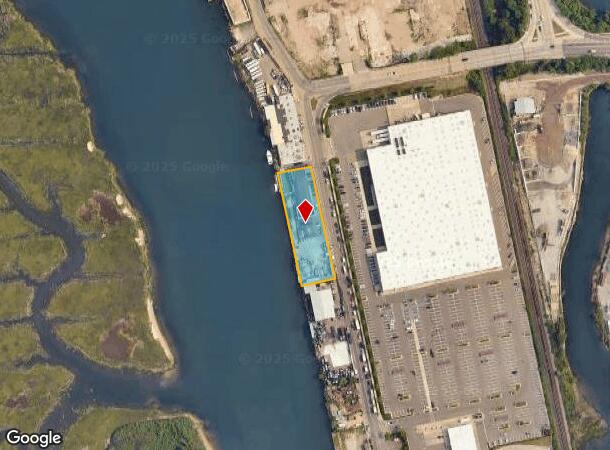
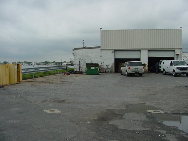
Property Record
3645 Hampton Rd, Oceanside, NY 11572
NEARBY LISTINGS FOR SALE OR LEASE
Property Detail
3645 Hampton Rd
2089-43-400-00-0508-0
TOWN #1 SCH DIST 011
Shipyard
Nassau
AE
New York
36059C0307G
508
2025
0.78 AC
2025
Southern Nassau
413200
Long Island (New York)
12,547 SF
Nassau County-Suffolk County, NY
DEMOGRAPHICS near 3645 Hampton Rd
1 Mile
3 Mile
5 Mile
2024 Total Population
8,784
129,232
349,489
2029 Population
8,591
126,696
342,163
Pop Growth 2024-2029
(2.20%)
(1.96%)
(2.10%)
Average Age
44
43
41
2024 Total Households
3,351
48,874
118,431
HH Growth 2024-2029
(2.27%)
(1.97%)
(2.15%)
Median Household Inc
$91,322
$116,501
$118,675
Avg Household Size
2.60
2.60
2.80
2024 Avg HH Vehicles
2.00
2.00
2.00
Median Home Value
$614,085
$665,327
$642,856
Median Year Built
1963
1956
1953
Nearby Places
- Restaurants
- Banks
- Shops
- Fitness
- Groceries
PUBLIC TRANSPORTATION
COMMUTER RAIL
Oceanside Station (Long Beach Branch - Long Island Rail Road)
DRIVE
WALK
Distance
Oceanside Station (Long Beach Branch - Long Island Rail Road)
3 min
1.3 mi
Island Park Station (Long Beach Branch - Long Island Rail Road)
DRIVE
WALK
Distance
Island Park Station (Long Beach Branch - Long Island Rail Road)
4 min
2.4 mi
AIRPORT
John F Kennedy International
DRIVE
WALK
Distance
John F Kennedy International
21 min
11.9 mi
LaGuardia
DRIVE
WALK
Distance
LaGuardia
31 min
18.9 mi
Newark Liberty International
DRIVE
WALK
Distance
Newark Liberty International
58 min
38.6 mi
Freight Ports
NY - Red Hook Container Terminal
DRIVE
WALK
Distance
NY - Red Hook Container Terminal
41 min
23.3 mi
Nearby Properties
Address
Land Use
TOTAL SIZE
Lot Size
Zoning
Address
Land Use
TOTAL SIZE
Lot Size
Zoning
Address
Land Use
TOTAL SIZE
Lot Size
Zoning
Address
Land Use
TOTAL SIZE
Lot Size
Zoning
5,800 SF
10.48 AC
Address
Land Use
TOTAL SIZE
Lot Size
Zoning
88.30 AC
Address
Land Use
TOTAL SIZE
Lot Size
Zoning
350.74 AC
Address
Land Use
TOTAL SIZE
Lot Size
Zoning
336,450 SF
139.91 AC
Address
Land Use
TOTAL SIZE
Lot Size
Zoning
30,700 SF
88.36 AC
Address
Land Use
TOTAL SIZE
Lot Size
Zoning
58,400 SF
58.17 AC
Address
Land Use
TOTAL SIZE
Lot Size
Zoning
133.85 AC
Address
Land Use
TOTAL SIZE
Lot Size
Zoning
195,575 SF
35.93 AC
Address
Land Use
TOTAL SIZE
Lot Size
Zoning
197,920 SF
16.50 AC
Address
Land Use
TOTAL SIZE
Lot Size
Zoning
92.92 AC
Address
Land Use
TOTAL SIZE
Lot Size
Zoning
57,970 SF
1.69 AC
Address
Land Use
TOTAL SIZE
Lot Size
Zoning
80.84 AC
Address
Land Use
TOTAL SIZE
Lot Size
Zoning
Address
Land Use
TOTAL SIZE
Lot Size
Zoning
227,776 SF
16.06 AC
Address
Land Use
TOTAL SIZE
Lot Size
Zoning
151,757 SF
34.38 AC
Address
Land Use
TOTAL SIZE
Lot Size
Zoning
99,904 SF
20.17 AC
Address
Land Use
TOTAL SIZE
Lot Size
Zoning
357,868 SF
24.92 AC
Address
Land Use
TOTAL SIZE
Lot Size
Zoning
66.41 AC
Address
Land Use
TOTAL SIZE
Lot Size
Zoning
6,258 SF
34.59 AC
Address
Land Use
TOTAL SIZE
Lot Size
Zoning
1,664 SF
32.13 AC
Address
Land Use
TOTAL SIZE
Lot Size
Zoning
61.52 AC
Address
Land Use
TOTAL SIZE
Lot Size
Zoning
61.52 AC
Address
Land Use
TOTAL SIZE
Lot Size
Zoning
74,813 SF
4.56 AC
Address
Land Use
TOTAL SIZE
Lot Size
Zoning
58.86 AC
Address
Land Use
TOTAL SIZE
Lot Size
Zoning
60.30 AC
Address
Land Use
TOTAL SIZE
Lot Size
Zoning
484,552 SF
11.56 AC
Address
Land Use
TOTAL SIZE
Lot Size
Zoning
59,715 SF
12.81 AC
Address
Land Use
TOTAL SIZE
Lot Size
Zoning
41,612 SF
3.89 AC
The World's #1 Commercial Real Estate Marketplace
Connect with us
© 2025 CoStar Group
The information above has been obtained from sources believed reliable. While we do not doubt its accuracy we have not verified it and make no guarantee, warranty or representation about it. It is your responsibility to independently confirm its accuracy and completeness. Any projections, opinions, assumptions, or estimates used are for example only and do not represent the current or future performance of the property. The value of this transaction to you depends on tax and other factors which should be evaluated by your tax, financial, and legal advisors. You and your advisors should conduct a careful, independent investigation of the property to determine to your satisfaction the suitability of the property for your needs.