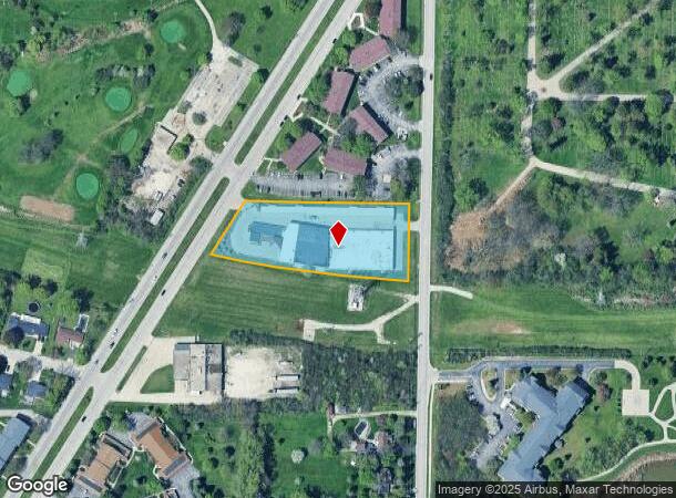
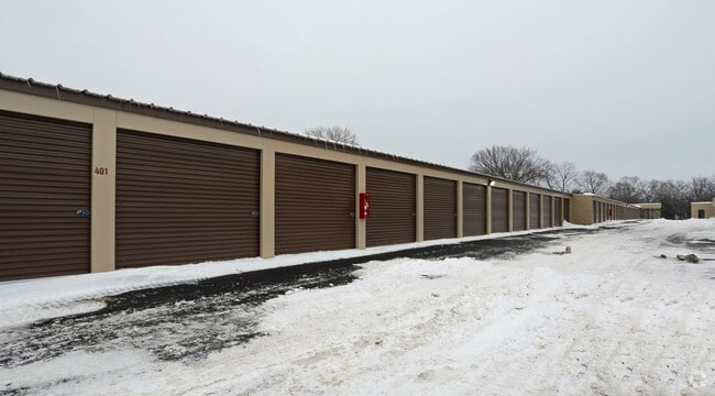
Property Record
3645 W Loomis Rd, Milwaukee, WI 53221

NEARBY LISTINGS FOR SALE OR LEASE
Property Detail
3645 W Loomis Rd
Milwaukee-Waukesha-West Allis, WI
Certified Survey Map #5248
575-8897-006
MAP 8736
Commercialnec
Milwaukee
X
Wisconsin
55079C0152E
1
2023
1.94 AC
2024
Milwaukee Near SW
021500
Milwaukee/Madison
DEMOGRAPHICS near 3645 W Loomis Rd
1 Mile
3 Mile
5 Mile
2024 Total Population
13,411
151,251
337,687
2029 Population
13,038
147,036
329,231
Pop Growth 2024-2029
(2.78%)
(2.79%)
(2.50%)
Average Age
39
38
38
2024 Total Households
5,708
59,258
140,207
HH Growth 2024-2029
(2.89%)
(2.86%)
(2.53%)
Median Household Inc
$50,426
$58,235
$57,833
Avg Household Size
2.30
2.50
2.30
2024 Avg HH Vehicles
1.00
2.00
2.00
Median Home Value
$195,625
$179,198
$187,407
Median Year Built
1961
1956
1954
Nearby Places
Map Layers
Map Styles
 Street
 Aerial
- Restaurants
- Banks
- Shops
- Fitness
- Groceries
PUBLIC TRANSPORTATION
AIRPORT
General Mitchell International
DRIVE
WALK
Distance
General Mitchell International
12 min
5.2 mi
SALE & LEASE HISTORY
LISTING DATE
SALE/LEASE

Dec 09, 2016
For Lease
Nearby Properties
Address
Land Use
TOTAL SIZE
Lot Size
Zoning
Address
Land Use
TOTAL SIZE
Lot Size
Zoning
19.92 AC
Address
Land Use
TOTAL SIZE
Lot Size
Zoning
48.34 AC
IO1
Address
Land Use
TOTAL SIZE
Lot Size
Zoning
197,354 SF
18 AC
CS
Address
Land Use
TOTAL SIZE
Lot Size
Zoning
183,291 SF
11.48 AC
IM
Address
Land Use
TOTAL SIZE
Lot Size
Zoning
23.09 AC
Address
Land Use
TOTAL SIZE
Lot Size
Zoning
188,328 SF
22.41 AC
PD
Address
Land Use
TOTAL SIZE
Lot Size
Zoning
17.47 AC
R2
Address
Land Use
TOTAL SIZE
Lot Size
Zoning
Address
Land Use
TOTAL SIZE
Lot Size
Zoning
262,150 SF
14.62 AC
PUDR5
Address
Land Use
TOTAL SIZE
Lot Size
Zoning
39.81 AC
Address
Land Use
TOTAL SIZE
Lot Size
Zoning
238,201 SF
17.96 AC
PUDR5
Address
Land Use
TOTAL SIZE
Lot Size
Zoning
228,912 SF
16.77 AC
Address
Land Use
TOTAL SIZE
Lot Size
Zoning
Address
Land Use
TOTAL SIZE
Lot Size
Zoning
20.61 AC
TL
Address
Land Use
TOTAL SIZE
Lot Size
Zoning
162,138 SF
9.15 AC
PD
Address
Land Use
TOTAL SIZE
Lot Size
Zoning
213,964 SF
13.94 AC
PUDR5
Address
Land Use
TOTAL SIZE
Lot Size
Zoning
132,289 SF
5.34 AC
PD
Address
Land Use
TOTAL SIZE
Lot Size
Zoning
13.84 AC
Address
Land Use
TOTAL SIZE
Lot Size
Zoning
360,000 SF
14.60 AC
IL1
Address
Land Use
TOTAL SIZE
Lot Size
Zoning
174,510 SF
7.37 AC
PD
Address
Land Use
TOTAL SIZE
Lot Size
Zoning
20.49 AC
TL
Address
Land Use
TOTAL SIZE
Lot Size
Zoning
4.27 AC
Address
Land Use
TOTAL SIZE
Lot Size
Zoning
11.33 AC
Address
Land Use
TOTAL SIZE
Lot Size
Zoning
152,130 SF
7.68 AC
PD
Address
Land Use
TOTAL SIZE
Lot Size
Zoning
130,723 SF
12.94 AC
C2
Address
Land Use
TOTAL SIZE
Lot Size
Zoning
205,632 SF
18 AC
PD
Address
Land Use
TOTAL SIZE
Lot Size
Zoning
156,753 SF
12.28 AC
LB1
Address
Land Use
TOTAL SIZE
Lot Size
Zoning
Address
Land Use
TOTAL SIZE
Lot Size
Zoning
4.16 AC
Address
Land Use
TOTAL SIZE
Lot Size
Zoning
10.43 AC
The World's #1 Commercial Real Estate Marketplace
Connect with us
© 2025 CoStar Group
The information above has been obtained from sources believed reliable. While we do not doubt its accuracy we have not verified it and make no guarantee, warranty or representation about it. It is your responsibility to independently confirm its accuracy and completeness. Any projections, opinions, assumptions, or estimates used are for example only and do not represent the current or future performance of the property. The value of this transaction to you depends on tax and other factors which should be evaluated by your tax, financial, and legal advisors. You and your advisors should conduct a careful, independent investigation of the property to determine to your satisfaction the suitability of the property for your needs.