Property Record
3647 N Us Highway 395 S, Carson City, NV 89705
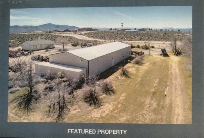
This Property Is For Sale
NEARBY LISTINGS FOR SALE OR LEASE
-
-
View all Carson City listings for sale on LoopNet.com
Property Detail
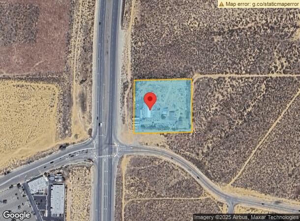
3647 N Us Highway 395 S
Gardnerville Ranchos, NV
Douglas
1420-06-801-001
Nevada
Sfr
2.73 AC
X
Douglas County
32005C0057H
Reno/Sparks
1,362 SF
DEMOGRAPHICS near 3647 N Us Highway 395 S
1 Mile
3 Mile
5 Mile
2024 Total Population
4,368
15,696
36,464
2029 Population
4,450
15,814
36,760
Pop Growth 2024-2029
+ 1.88%
+ 0.75%
+ 0.81%
Average Age
44
45
45
2024 Total Households
1,713
5,918
14,463
HH Growth 2024-2029
+ 1.87%
+ 0.84%
+ 0.94%
Median Household Inc
$75,241
$77,784
$75,507
Avg Household Size
2.50
2.40
2.30
2024 Avg HH Vehicles
2.00
2.00
2.00
Median Home Value
$451,900
$436,432
$443,407
Median Year Built
1994
1988
1985
Nearby Places
- Restaurants
- Banks
- Shops
- Fitness
- Groceries
PUBLIC TRANSPORTATION
AIRPORT
Reno/Tahoe International
DRIVE
WALK
Distance
Reno/Tahoe International
58 min
37.5 mi
Freight Ports
Port of Stockton
DRIVE
WALK
Distance
Port of Stockton
211 min
146.8 mi
Nearby Properties
Address
Land Use
TOTAL SIZE
Lot Size
Zoning
Address
Land Use
TOTAL SIZE
Lot Size
Zoning
395,706 SF
998.20 AC
A-P
Address
Land Use
TOTAL SIZE
Lot Size
Zoning
351,100 SF
22.10 AC
MFA-GC
Address
Land Use
TOTAL SIZE
Lot Size
Zoning
230,573 SF
21.37 AC
Address
Land Use
TOTAL SIZE
Lot Size
Zoning
199,052 SF
7.46 AC
GC
Address
Land Use
TOTAL SIZE
Lot Size
Zoning
224,615 SF
21.47 AC
Address
Land Use
TOTAL SIZE
Lot Size
Zoning
590.48 AC
PR
Address
Land Use
TOTAL SIZE
Lot Size
Zoning
287,038 SF
49.20 AC
P
Address
Land Use
TOTAL SIZE
Lot Size
Zoning
148,474 SF
16.08 AC
GC
Address
Land Use
TOTAL SIZE
Lot Size
Zoning
122,492 SF
9.13 AC
Address
Land Use
TOTAL SIZE
Lot Size
Zoning
60,217 SF
1.84 AC
GC
Address
Land Use
TOTAL SIZE
Lot Size
Zoning
117,028 SF
10.99 AC
Address
Land Use
TOTAL SIZE
Lot Size
Zoning
20,135 SF
8.49 AC
GC
Address
Land Use
TOTAL SIZE
Lot Size
Zoning
48,237 SF
8.64 AC
MFA-GC
Address
Land Use
TOTAL SIZE
Lot Size
Zoning
43,789 SF
5.86 AC
RC
Address
Land Use
TOTAL SIZE
Lot Size
Zoning
25,392 SF
3.98 AC
RC
Address
Land Use
TOTAL SIZE
Lot Size
Zoning
30,840 SF
61.75 AC
Address
Land Use
TOTAL SIZE
Lot Size
Zoning
56,378 SF
9 AC
Address
Land Use
TOTAL SIZE
Lot Size
Zoning
39,420 SF
0.44 AC
Address
Land Use
TOTAL SIZE
Lot Size
Zoning
92,648 SF
6.08 AC
GC
Address
Land Use
TOTAL SIZE
Lot Size
Zoning
33,271 SF
3.86 AC
RC
Address
Land Use
TOTAL SIZE
Lot Size
Zoning
26,602 SF
3.16 AC
GC
Address
Land Use
TOTAL SIZE
Lot Size
Zoning
1,313 SF
17.75 AC
PR
Address
Land Use
TOTAL SIZE
Lot Size
Zoning
160 AC
PR
Address
Land Use
TOTAL SIZE
Lot Size
Zoning
65,219 SF
20 AC
P
Address
Land Use
TOTAL SIZE
Lot Size
Zoning
Address
Land Use
TOTAL SIZE
Lot Size
Zoning
43,800 SF
10.02 AC
PR
Address
Land Use
TOTAL SIZE
Lot Size
Zoning
83,415 SF
5.89 AC
GC
Address
Land Use
TOTAL SIZE
Lot Size
Zoning
49,916 SF
15.62 AC
PR
Address
Land Use
TOTAL SIZE
Lot Size
Zoning
25,333 SF
3.50 AC
RC
The World's #1 Commercial Real Estate Marketplace
Connect with us
© 2025 CoStar Group
The information above has been obtained from sources believed reliable. While we do not doubt its accuracy we have not verified it and make no guarantee, warranty or representation about it. It is your responsibility to independently confirm its accuracy and completeness. Any projections, opinions, assumptions, or estimates used are for example only and do not represent the current or future performance of the property. The value of this transaction to you depends on tax and other factors which should be evaluated by your tax, financial, and legal advisors. You and your advisors should conduct a careful, independent investigation of the property to determine to your satisfaction the suitability of the property for your needs.