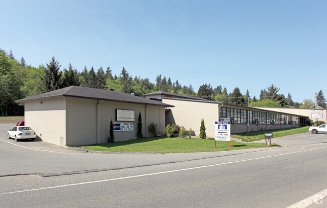
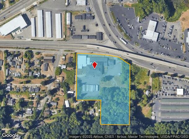
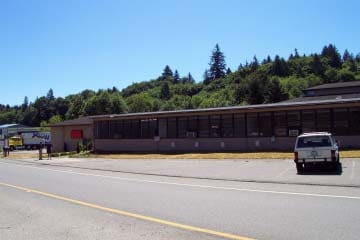
Property Record
3649 W Frontage Rd, Port Orchard, WA 98367
NEARBY LISTINGS FOR SALE OR LEASE
Property Detail
3649 W Frontage Rd
322401-4-024-2003
THAT PORTION OF GOVERNMENT LOT 2 AND THE NORTHWEST QUARTER OF THE SOUTHEAST QUARTER, SECTION 32, TOWNSHIP 24 NORTH, RANGE 1 EAST, W.M., DESCRIBED AS FOLLOWS: BEGINNING AT THE SOUTHEAST CORNER OF SAID SECTION; THENCE N15015 E ALONG THE EAST LINE THERE
Commercialnec
Kitsap
X
Washington
53035C0364F
2
2025
5.15 AC
2026
South Kitsap County
092102
Bremerton/Silverdale
4,268 SF
Bremerton-Silverdale-Port Orchard, WA
DEMOGRAPHICS near 3649 W Frontage Rd
1 Mile
3 Mile
5 Mile
2024 Total Population
1,566
24,083
77,911
2029 Population
1,574
24,790
79,185
Pop Growth 2024-2029
+ 0.51%
+ 2.94%
+ 1.64%
Average Age
36
39
39
2024 Total Households
536
9,255
29,005
HH Growth 2024-2029
+ 0.56%
+ 3.13%
+ 1.83%
Median Household Inc
$94,999
$75,081
$70,678
Avg Household Size
2.90
2.50
2.40
2024 Avg HH Vehicles
2.00
2.00
2.00
Median Home Value
$448,425
$413,148
$399,877
Median Year Built
1996
1994
1980
Nearby Places
Map Layers
Map Styles
 Street
 Aerial
- Restaurants
- Banks
- Shops
- Fitness
- Groceries
PUBLIC TRANSPORTATION
AIRPORT
Seattle Paine Field International
DRIVE
WALK
Distance
Seattle Paine Field International
93 min
45.6 mi
Seattle-Tacoma International
DRIVE
WALK
Distance
Seattle-Tacoma International
68 min
49.1 mi
Nearby Properties
Address
Land Use
TOTAL SIZE
Lot Size
Zoning
Address
Land Use
TOTAL SIZE
Lot Size
Zoning
552 SF
17.39 AC
CITY
Address
Land Use
TOTAL SIZE
Lot Size
Zoning
143,022 SF
11.24 AC
R4
Address
Land Use
TOTAL SIZE
Lot Size
Zoning
127,853 SF
7.41 AC
R4
Address
Land Use
TOTAL SIZE
Lot Size
Zoning
135,371 SF
6.04 AC
R4
Address
Land Use
TOTAL SIZE
Lot Size
Zoning
112,847 SF
6.80 AC
UM
Address
Land Use
TOTAL SIZE
Lot Size
Zoning
110,994 SF
5.35 AC
R4
Address
Land Use
TOTAL SIZE
Lot Size
Zoning
118,263 SF
27.49 AC
PSIC-B
Address
Land Use
TOTAL SIZE
Lot Size
Zoning
73,931 SF
11.72 AC
FC
Address
Land Use
TOTAL SIZE
Lot Size
Zoning
43,944 SF
2.64 AC
FC
Address
Land Use
TOTAL SIZE
Lot Size
Zoning
55,866 SF
8.48 AC
FC
Address
Land Use
TOTAL SIZE
Lot Size
Zoning
68,708 SF
7.89 AC
PF
Address
Land Use
TOTAL SIZE
Lot Size
Zoning
520 SF
7.79 AC
C
Address
Land Use
TOTAL SIZE
Lot Size
Zoning
42,665 SF
5.55 AC
FC
Address
Land Use
TOTAL SIZE
Lot Size
Zoning
51,933 SF
4.07 AC
C
Address
Land Use
TOTAL SIZE
Lot Size
Zoning
43,318 SF
2.54 AC
R4
Address
Land Use
TOTAL SIZE
Lot Size
Zoning
75,000 SF
3.61 AC
LI
Address
Land Use
TOTAL SIZE
Lot Size
Zoning
49,222 SF
3.39 AC
BPMU
Address
Land Use
TOTAL SIZE
Lot Size
Zoning
60,244 SF
8.83 AC
CC
Address
Land Use
TOTAL SIZE
Lot Size
Zoning
29,079 SF
9.95 AC
PF
Address
Land Use
TOTAL SIZE
Lot Size
Zoning
46,395 SF
2.41 AC
FC
Address
Land Use
TOTAL SIZE
Lot Size
Zoning
40,131 SF
4.90 AC
FC
Address
Land Use
TOTAL SIZE
Lot Size
Zoning
36,094 SF
2.84 AC
FC
Address
Land Use
TOTAL SIZE
Lot Size
Zoning
30,367 SF
4.55 AC
FC
Address
Land Use
TOTAL SIZE
Lot Size
Zoning
40,144 SF
5 AC
CITY
Address
Land Use
TOTAL SIZE
Lot Size
Zoning
31,961 SF
2.91 AC
R4
Address
Land Use
TOTAL SIZE
Lot Size
Zoning
38,580 SF
2.44 AC
I
Address
Land Use
TOTAL SIZE
Lot Size
Zoning
4,280 SF
0.95 AC
CC
Address
Land Use
TOTAL SIZE
Lot Size
Zoning
42,400 SF
5.40 AC
FC
Address
Land Use
TOTAL SIZE
Lot Size
Zoning
28,000 SF
3.78 AC
FC
Address
Land Use
TOTAL SIZE
Lot Size
Zoning
47,572 SF
2.73 AC
R4
The World's #1 Commercial Real Estate Marketplace
Connect with us
© 2026 CoStar Group
The information above has been obtained from sources believed reliable. While we do not doubt its accuracy we have not verified it and make no guarantee, warranty or representation about it. It is your responsibility to independently confirm its accuracy and completeness. Any projections, opinions, assumptions, or estimates used are for example only and do not represent the current or future performance of the property. The value of this transaction to you depends on tax and other factors which should be evaluated by your tax, financial, and legal advisors. You and your advisors should conduct a careful, independent investigation of the property to determine to your satisfaction the suitability of the property for your needs.