Property Record
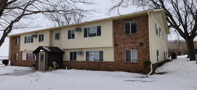
365 2Nd Ave Ne, Wells, MN 56097


Property Detail
365 2Nd Ave Ne
30.238.0210
1 & 2 BUTTERNUT FARM ADDITION 1 & 2
Apartment
Faribault
205
Minnesota
2025
0.76 AC
2025
Minnesota South Area
460600
Other Market Areas
7,040 SF
NEARBY LISTINGS FOR SALE OR LEASE
-
-
View all Wells listings for sale on LoopNet.com
DEMOGRAPHICS near 365 2Nd Ave Ne
1 mile
3 mile
5 mile
2025 Total Population
2,060
2,492
2,757
2030 Population
2,045
2,472
2,728
Pop Growth 2025-2030
(0.73%)
(0.80%)
(1.05%)
Average Age
42
42
42
2025 Total Households
858
1,042
1,157
HH Growth 2025-2030
(0.82%)
(0.77%)
(1.04%)
Median Household Inc
$59,874
$60,474
$61,689
Avg Household Size
2.30
2.30
2.30
2025 Avg HH Vehicles
2.00
2.00
2.00
Median Home Value
$100,541
$112,719
$123,809
Median Year Built
1953
1954
1954
Nearby Places
Map Layers
Map Styles
 Street
 Aerial
Layers
 Traffic
 Biking
Places
Listings with unknown addresses are not visible on the map
- Restaurants
- Banks
- Shops
- Fitness
- Groceries
SALE & LEASE HISTORY
LISTING DATE
SALE/LEASE

Jan 21, 2023
For Sale
Jan 20, 2017
For Sale
Nearby Properties
Address
Land Use
TOTAL SIZE
Lot Size
Zoning
Address
Land Use
TOTAL SIZE
Lot Size
Zoning
39.10 AC
Address
Land Use
TOTAL SIZE
Lot Size
Zoning
7,242 SF
309.77 AC
101
Address
Land Use
TOTAL SIZE
Lot Size
Zoning
4,928 SF
7.13 AC
233
Address
Land Use
TOTAL SIZE
Lot Size
Zoning
1,664 SF
195.97 AC
106
Address
Land Use
TOTAL SIZE
Lot Size
Zoning
251.09 AC
102
Address
Land Use
TOTAL SIZE
Lot Size
Zoning
24,000 SF
5.53 AC
234
Address
Land Use
TOTAL SIZE
Lot Size
Zoning
234.78 AC
101
Address
Land Use
TOTAL SIZE
Lot Size
Zoning
1,680 SF
154.17 AC
101
Address
Land Use
TOTAL SIZE
Lot Size
Zoning
1,884 SF
160.06 AC
101
Address
Land Use
TOTAL SIZE
Lot Size
Zoning
160 AC
101
Address
Land Use
TOTAL SIZE
Lot Size
Zoning
8,948 SF
0.44 AC
958
Address
Land Use
TOTAL SIZE
Lot Size
Zoning
3,200 SF
155.95 AC
101
Address
Land Use
TOTAL SIZE
Lot Size
Zoning
2,052 SF
140 AC
101
Address
Land Use
TOTAL SIZE
Lot Size
Zoning
1,392 SF
154.74 AC
101
Address
Land Use
TOTAL SIZE
Lot Size
Zoning
160 AC
101
Address
Land Use
TOTAL SIZE
Lot Size
Zoning
151.58 AC
Address
Land Use
TOTAL SIZE
Lot Size
Zoning
1,512 SF
140 AC
101
Address
Land Use
TOTAL SIZE
Lot Size
Zoning
147.30 AC
101
Address
Land Use
TOTAL SIZE
Lot Size
Zoning
160 AC
105
Address
Land Use
TOTAL SIZE
Lot Size
Zoning
1,498 SF
159 AC
101
Address
Land Use
TOTAL SIZE
Lot Size
Zoning
152 AC
105
Address
Land Use
TOTAL SIZE
Lot Size
Zoning
153.35 AC
101
Address
Land Use
TOTAL SIZE
Lot Size
Zoning
159.10 AC
101
Address
Land Use
TOTAL SIZE
Lot Size
Zoning
150.74 AC
106
Address
Land Use
TOTAL SIZE
Lot Size
Zoning
73,907 SF
1.37 AC
234
Address
Land Use
TOTAL SIZE
Lot Size
Zoning
153.10 AC
101
Address
Land Use
TOTAL SIZE
Lot Size
Zoning
140 AC
105
Address
Land Use
TOTAL SIZE
Lot Size
Zoning
160 SF
149.67 AC
105
Address
Land Use
TOTAL SIZE
Lot Size
Zoning
155.79 AC
101
The World's #1 Commercial Real Estate Marketplace
Connect with us
© 2026 CoStar Group
The information above has been obtained from sources believed reliable. While we do not doubt its accuracy we have not verified it and make no guarantee, warranty or representation about it. It is your responsibility to independently confirm its accuracy and completeness. Any projections, opinions, assumptions, or estimates used are for example only and do not represent the current or future performance of the property. The value of this transaction to you depends on tax and other factors which should be evaluated by your tax, financial, and legal advisors. You and your advisors should conduct a careful, independent investigation of the property to determine to your satisfaction the suitability of the property for your needs.