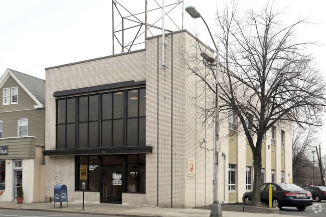
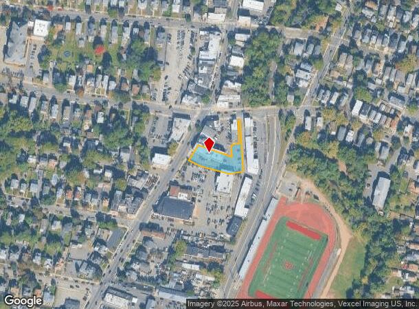
Property Record
365 Broad St, Newark, NJ 07104
NEARBY LISTINGS FOR SALE OR LEASE
-
-
-
-
-
-
-
-
-
-
-
No Photo
-
-
View all Newark listings for lease on LoopNet.com
Property Detail
365 Broad St
02-00576-0000-00005
76 X 220 AVG + REAR
Financialbuilding
Essex
X
New Jersey
34013C0112G
5
2023
0.38 AC
2025
Bloomfield/GSP
015400
Northern New Jersey
8,119 SF
Newark, NJ-PA
DEMOGRAPHICS near 365 Broad St
1 Mile
3 Mile
5 Mile
2024 Total Population
28,543
271,497
690,037
2029 Population
27,995
265,310
673,099
Pop Growth 2024-2029
(1.92%)
(2.28%)
(2.45%)
Average Age
40
40
39
2024 Total Households
11,820
104,097
254,537
HH Growth 2024-2029
(1.97%)
(2.40%)
(2.53%)
Median Household Inc
$84,337
$77,221
$73,811
Avg Household Size
2.30
2.50
2.60
2024 Avg HH Vehicles
2.00
1.00
1.00
Median Home Value
$440,521
$410,919
$433,657
Median Year Built
1953
1951
1955
Nearby Places
Map Layers
Map Styles
 Street
 Aerial
- Restaurants
- Banks
- Shops
- Fitness
- Groceries
PUBLIC TRANSPORTATION
COMMUTER RAIL
Glen Ridge (Montclair-Boonton Line - NJ Transit Commuter Rail (NJ Transit))
DRIVE
WALK
Distance
Glen Ridge (Montclair-Boonton Line - NJ Transit Commuter Rail (NJ Transit))
3 min
17 min
0.9 mi
Bay Street (Montclair-Boonton Line - NJ Transit Commuter Rail (NJ Transit))
DRIVE
WALK
Distance
Bay Street (Montclair-Boonton Line - NJ Transit Commuter Rail (NJ Transit))
5 min
1.4 mi
AIRPORT
Newark Liberty International
DRIVE
WALK
Distance
Newark Liberty International
21 min
12.4 mi
LaGuardia
DRIVE
WALK
Distance
LaGuardia
45 min
24.6 mi
John F Kennedy International
DRIVE
WALK
Distance
John F Kennedy International
55 min
32.7 mi
Freight Ports
Maher Terminal
DRIVE
WALK
Distance
Maher Terminal
26 min
13.5 mi
SALE & LEASE HISTORY
LISTING DATE
SALE/LEASE

Sep 30, 2020
For Lease
Sep 29, 2017
For Lease
Sep 25, 2016
For Lease
Sep 12, 2018
For Lease
Jul 26, 2017
For Lease
Nearby Properties
Address
Land Use
TOTAL SIZE
Lot Size
Zoning
Address
Land Use
TOTAL SIZE
Lot Size
Zoning
5 AC
H
Address
Land Use
TOTAL SIZE
Lot Size
Zoning
17.97 AC
Address
Land Use
TOTAL SIZE
Lot Size
Zoning
Address
Land Use
TOTAL SIZE
Lot Size
Zoning
16,084 SF
7.23 AC
Address
Land Use
TOTAL SIZE
Lot Size
Zoning
1,589 SF
R4
Address
Land Use
TOTAL SIZE
Lot Size
Zoning
12.54 AC
OPRP
Address
Land Use
TOTAL SIZE
Lot Size
Zoning
3.31 AC
Address
Land Use
TOTAL SIZE
Lot Size
Zoning
Address
Land Use
TOTAL SIZE
Lot Size
Zoning
1.12 AC
M-O
Address
Land Use
TOTAL SIZE
Lot Size
Zoning
2.64 AC
Address
Land Use
TOTAL SIZE
Lot Size
Zoning
Address
Land Use
TOTAL SIZE
Lot Size
Zoning
11.49 AC
M-1
Address
Land Use
TOTAL SIZE
Lot Size
Zoning
31.36 AC
P-6
Address
Land Use
TOTAL SIZE
Lot Size
Zoning
306,414 SF
4.62 AC
Address
Land Use
TOTAL SIZE
Lot Size
Zoning
3.26 AC
PR
Address
Land Use
TOTAL SIZE
Lot Size
Zoning
0.17 AC
BCR1
Address
Land Use
TOTAL SIZE
Lot Size
Zoning
1.67 AC
BCR1
Address
Land Use
TOTAL SIZE
Lot Size
Zoning
3.20 AC
BSRD
Address
Land Use
TOTAL SIZE
Lot Size
Zoning
224 SF
0.94 AC
BCR1
Address
Land Use
TOTAL SIZE
Lot Size
Zoning
1.50 AC
RA
Address
Land Use
TOTAL SIZE
Lot Size
Zoning
1.95 AC
RA
Address
Land Use
TOTAL SIZE
Lot Size
Zoning
3.64 AC
R-M
Address
Land Use
TOTAL SIZE
Lot Size
Zoning
9.98 AC
R-1
Address
Land Use
TOTAL SIZE
Lot Size
Zoning
0.22 AC
Address
Land Use
TOTAL SIZE
Lot Size
Zoning
364.34 AC
R-1
Address
Land Use
TOTAL SIZE
Lot Size
Zoning
3.04 AC
Address
Land Use
TOTAL SIZE
Lot Size
Zoning
7.22 AC
M-3
Address
Land Use
TOTAL SIZE
Lot Size
Zoning
228,736 SF
48.25 AC
Address
Land Use
TOTAL SIZE
Lot Size
Zoning
10.40 AC
Address
Land Use
TOTAL SIZE
Lot Size
Zoning
4.09 AC
M-O
The World's #1 Commercial Real Estate Marketplace
Connect with us
© 2025 CoStar Group
The information above has been obtained from sources believed reliable. While we do not doubt its accuracy we have not verified it and make no guarantee, warranty or representation about it. It is your responsibility to independently confirm its accuracy and completeness. Any projections, opinions, assumptions, or estimates used are for example only and do not represent the current or future performance of the property. The value of this transaction to you depends on tax and other factors which should be evaluated by your tax, financial, and legal advisors. You and your advisors should conduct a careful, independent investigation of the property to determine to your satisfaction the suitability of the property for your needs.