Property Record
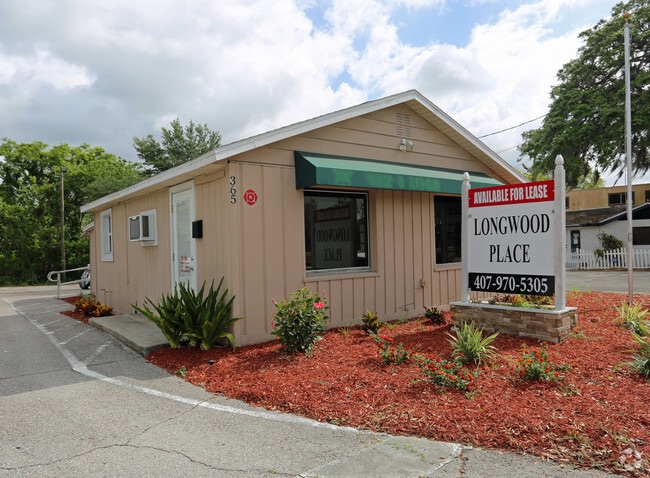
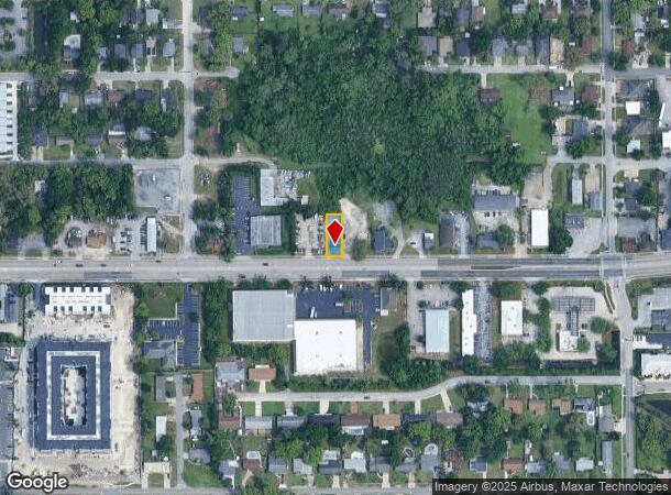
365 E State Road 434, Longwood, FL 32750

Current Lease Availabilities
NEARBY LISTINGS FOR SALE OR LEASE
Property Detail
365 E State Road 434
Orlando-Kissimmee-Sanford, FL
Longwood
31-20-30-5AU-0000-8400
LOT 840 (LESS RD) LONGWOOD PB 1 PG 21
Miscresidentialimprovement
Seminole
X
Florida
12117C0155F
840
2024
0.15 AC
2024
Longwood
021507
Orlando
916 SF
DEMOGRAPHICS near 365 E State Road 434
1 Mile
3 Mile
5 Mile
2024 Total Population
8,707
74,788
207,042
2029 Population
9,111
77,854
215,590
Pop Growth 2024-2029
+ 4.64%
+ 4.10%
+ 4.13%
Average Age
42
42
42
2024 Total Households
3,363
29,703
84,353
HH Growth 2024-2029
+ 4.79%
+ 4.22%
+ 4.32%
Median Household Inc
$58,275
$64,218
$67,743
Avg Household Size
2.50
2.50
2.40
2024 Avg HH Vehicles
2.00
2.00
2.00
Median Home Value
$271,524
$281,705
$310,213
Median Year Built
1981
1981
1983
Nearby Places
- Restaurants
- Banks
- Shops
- Fitness
- Groceries
PUBLIC TRANSPORTATION
COMMUTER RAIL
DRIVE
WALK
Distance
2 min
10 min
0.5 mi
DRIVE
WALK
Distance
7 min
3.2 mi
AIRPORT
Orlando Sanford International
DRIVE
WALK
Distance
Orlando Sanford International
18 min
10.0 mi
Orlando International
DRIVE
WALK
Distance
Orlando International
35 min
20.4 mi
Daytona Beach International
DRIVE
WALK
Distance
Daytona Beach International
56 min
44.5 mi
Freight Ports
Port Canaveral
DRIVE
WALK
Distance
Port Canaveral
80 min
62.0 mi
Nearby Properties
Address
Land Use
TOTAL SIZE
Lot Size
Zoning
Address
Land Use
TOTAL SIZE
Lot Size
Zoning
21.25 AC
GC
Address
Land Use
TOTAL SIZE
Lot Size
Zoning
1,158 SF
17.22 AC
Address
Land Use
TOTAL SIZE
Lot Size
Zoning
629,182 SF
1.81 AC
R1A
Address
Land Use
TOTAL SIZE
Lot Size
Zoning
206 SF
1.43 AC
VMU
Address
Land Use
TOTAL SIZE
Lot Size
Zoning
400 SF
13.82 AC
R1AA
Address
Land Use
TOTAL SIZE
Lot Size
Zoning
231,070 SF
35.59 AC
MOR2
Address
Land Use
TOTAL SIZE
Lot Size
Zoning
350,767 SF
11.12 AC
PUD
Address
Land Use
TOTAL SIZE
Lot Size
Zoning
456 SF
9.56 AC
Address
Land Use
TOTAL SIZE
Lot Size
Zoning
97,888 SF
3.72 AC
IND
Address
Land Use
TOTAL SIZE
Lot Size
Zoning
17,728 SF
14.64 AC
GC
Address
Land Use
TOTAL SIZE
Lot Size
Zoning
147,310 SF
16.71 AC
GC
Address
Land Use
TOTAL SIZE
Lot Size
Zoning
560,170 SF
32.59 AC
M1A
Address
Land Use
TOTAL SIZE
Lot Size
Zoning
365,430 SF
2.70 AC
RMF13
Address
Land Use
TOTAL SIZE
Lot Size
Zoning
204 SF
30 AC
R3
Address
Land Use
TOTAL SIZE
Lot Size
Zoning
3,486 SF
13.28 AC
R3
Address
Land Use
TOTAL SIZE
Lot Size
Zoning
390,293 SF
47.33 AC
PI
Address
Land Use
TOTAL SIZE
Lot Size
Zoning
1,518 SF
12.08 AC
PUD
Address
Land Use
TOTAL SIZE
Lot Size
Zoning
1,696 SF
0.16 AC
A1
Address
Land Use
TOTAL SIZE
Lot Size
Zoning
212,638 SF
28.72 AC
M1
Address
Land Use
TOTAL SIZE
Lot Size
Zoning
153,728 SF
9.81 AC
R3
Address
Land Use
TOTAL SIZE
Lot Size
Zoning
5,935 SF
2.27 AC
RMF13
Address
Land Use
TOTAL SIZE
Lot Size
Zoning
182,134 SF
9.71 AC
R3
Address
Land Use
TOTAL SIZE
Lot Size
Zoning
8,975 SF
13.13 AC
C1
Address
Land Use
TOTAL SIZE
Lot Size
Zoning
101,404 SF
8.77 AC
MOR2
Address
Land Use
TOTAL SIZE
Lot Size
Zoning
195,936 SF
58.50 AC
PUD
Address
Land Use
TOTAL SIZE
Lot Size
Zoning
136,532 SF
12.13 AC
GC
Address
Land Use
TOTAL SIZE
Lot Size
Zoning
121,655 SF
10.65 AC
M1A
Address
Land Use
TOTAL SIZE
Lot Size
Zoning
220 SF
7.72 AC
GC
Address
Land Use
TOTAL SIZE
Lot Size
Zoning
155,159 SF
11.15 AC
C2
Address
Land Use
TOTAL SIZE
Lot Size
Zoning
140,456 SF
8.45 AC
R1
The World's #1 Commercial Real Estate Marketplace
Connect with us
© 2025 CoStar Group
The information above has been obtained from sources believed reliable. While we do not doubt its accuracy we have not verified it and make no guarantee, warranty or representation about it. It is your responsibility to independently confirm its accuracy and completeness. Any projections, opinions, assumptions, or estimates used are for example only and do not represent the current or future performance of the property. The value of this transaction to you depends on tax and other factors which should be evaluated by your tax, financial, and legal advisors. You and your advisors should conduct a careful, independent investigation of the property to determine to your satisfaction the suitability of the property for your needs.