Property Record
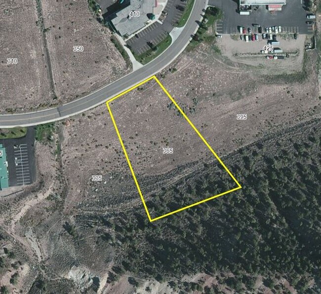
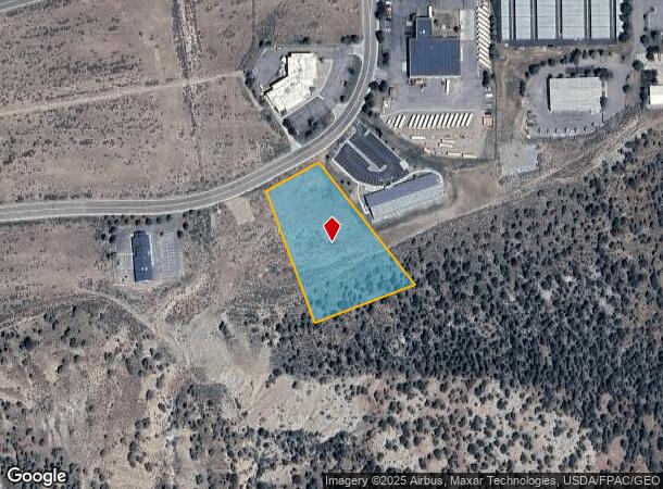
365 Mcgregor Dr, Gypsum Area, CO 81637

Property Detail
365 Mcgregor Dr
Edwards, CO
Airport Gateway Center
R044513
SUBDIVISION: AIRPORT GATEWAY CENTER LOT: 77
Taxexempt
Eagle
X
Colorado
08037C0369D
77
0
2.15 AC
2024
Colorado Ski Area
000100
Other Market Areas
NEARBY LISTINGS FOR SALE OR LEASE
DEMOGRAPHICS near 365 Mcgregor Dr
1 mile
3 mile
5 mile
2024 Total Population
17
4,692
13,619
2029 Population
16
4,430
12,880
Pop Growth 2024-2029
(5.88%)
(5.58%)
(5.43%)
Average Age
31
35
36
2024 Total Households
5
1,467
4,323
HH Growth 2024-2029
0.00%
(6.54%)
(6.34%)
Median Household Inc
$74,999
$93,181
$89,890
Avg Household Size
3.00
3.00
3.00
2024 Avg HH Vehicles
2.00
2.00
2.00
Median Home Value
$625,000
$665,400
$666,047
Median Year Built
1997
1998
1997
Nearby Places
Map Layers
Map Styles
 Street
 Aerial
Transit
 Traffic
 Biking
Places
Listings with unknown addresses are not visible on the map
- Restaurants
- Banks
- Shops
- Fitness
- Groceries
PUBLIC TRANSPORTATION
AIRPORT
Eagle County Regional
Drive
Walk
Distance
Eagle County Regional
5 min
2.4 mi
SALE & LEASE HISTORY
LISTING DATE
SALE/LEASE

Jul 20, 2020
For Sale
Nearby Properties
Address
Land Use
TOTAL SIZE
Lot Size
Zoning
Address
Land Use
TOTAL SIZE
Lot Size
Zoning
163,839 SF
18.42 AC
Address
Land Use
TOTAL SIZE
Lot Size
Zoning
55,579 SF
2.37 AC
Address
Land Use
TOTAL SIZE
Lot Size
Zoning
37,376 SF
14.08 AC
Address
Land Use
TOTAL SIZE
Lot Size
Zoning
57,479 SF
146.80 AC
Address
Land Use
TOTAL SIZE
Lot Size
Zoning
71,441 SF
4.79 AC
Address
Land Use
TOTAL SIZE
Lot Size
Zoning
80,005 SF
4.06 AC
Address
Land Use
TOTAL SIZE
Lot Size
Zoning
50,824 SF
2.32 AC
Address
Land Use
TOTAL SIZE
Lot Size
Zoning
62,400 SF
5.36 AC
Address
Land Use
TOTAL SIZE
Lot Size
Zoning
35,298 SF
3.88 AC
Address
Land Use
TOTAL SIZE
Lot Size
Zoning
40,050 SF
2.62 AC
Address
Land Use
TOTAL SIZE
Lot Size
Zoning
55,995 SF
94.35 AC
Address
Land Use
TOTAL SIZE
Lot Size
Zoning
19,588 SF
439.36 AC
Address
Land Use
TOTAL SIZE
Lot Size
Zoning
30,794 SF
1.61 AC
Address
Land Use
TOTAL SIZE
Lot Size
Zoning
22,775 SF
1.47 AC
Address
Land Use
TOTAL SIZE
Lot Size
Zoning
23,404 SF
1.66 AC
Address
Land Use
TOTAL SIZE
Lot Size
Zoning
16.62 AC
Address
Land Use
TOTAL SIZE
Lot Size
Zoning
89,757 SF
3.57 AC
Address
Land Use
TOTAL SIZE
Lot Size
Zoning
35,800 SF
2.92 AC
Address
Land Use
TOTAL SIZE
Lot Size
Zoning
35,260 SF
4.25 AC
Address
Land Use
TOTAL SIZE
Lot Size
Zoning
121,154 SF
11.05 AC
Address
Land Use
TOTAL SIZE
Lot Size
Zoning
14,264 SF
10.50 AC
Address
Land Use
TOTAL SIZE
Lot Size
Zoning
77,072 SF
1.72 AC
Address
Land Use
TOTAL SIZE
Lot Size
Zoning
25,310 SF
14.46 AC
Address
Land Use
TOTAL SIZE
Lot Size
Zoning
20,080 SF
2.06 AC
Address
Land Use
TOTAL SIZE
Lot Size
Zoning
23,141 SF
3.54 AC
Address
Land Use
TOTAL SIZE
Lot Size
Zoning
43,200 SF
2.30 AC
Address
Land Use
TOTAL SIZE
Lot Size
Zoning
24,000 SF
1.57 AC
Address
Land Use
TOTAL SIZE
Lot Size
Zoning
24,605 SF
1.99 AC
Address
Land Use
TOTAL SIZE
Lot Size
Zoning
14,400 SF
5.97 AC
Address
Land Use
TOTAL SIZE
Lot Size
Zoning
13,400 SF
1.72 AC
The World's #1 Commercial Real Estate Marketplace
Connect with us
© 2026 CoStar Group
The information above has been obtained from sources believed reliable. While we do not doubt its accuracy we have not verified it and make no guarantee, warranty or representation about it. It is your responsibility to independently confirm its accuracy and completeness. Any projections, opinions, assumptions, or estimates used are for example only and do not represent the current or future performance of the property. The value of this transaction to you depends on tax and other factors which should be evaluated by your tax, financial, and legal advisors. You and your advisors should conduct a careful, independent investigation of the property to determine to your satisfaction the suitability of the property for your needs.