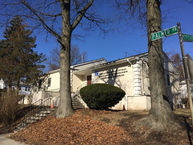
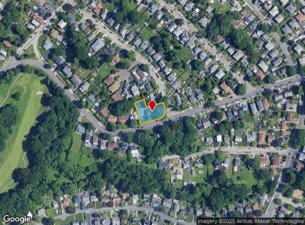
Property Record
359 Palmer Rd, Yonkers, NY 10701

NEARBY LISTINGS FOR SALE OR LEASE
Property Detail
359 Palmer Rd
1800-002-000-02283-000-0045-52
Map Of Hillcroft In The City Of Yonkers
Religious
Westchester
X
New York
36119C0328F
45.052
2025
0.37 AC
2024
Southwest
000501
Westchester/So Connecticut
2,452 SF
New York-Jersey City-White Plains, NY-NJ
DEMOGRAPHICS near 359 Palmer Rd
1 Mile
3 Mile
5 Mile
2024 Total Population
18,670
278,724
669,576
2029 Population
17,809
271,088
639,331
Pop Growth 2024-2029
(4.61%)
(2.74%)
(4.52%)
Average Age
42
41
41
2024 Total Households
6,934
106,313
248,333
HH Growth 2024-2029
(4.73%)
(2.84%)
(4.77%)
Median Household Inc
$82,348
$75,106
$76,818
Avg Household Size
2.50
2.50
2.60
2024 Avg HH Vehicles
2.00
1.00
1.00
Median Home Value
$423,997
$488,236
$578,729
Median Year Built
1955
1953
1953
Nearby Places
Map Layers
Map Styles
 Street
 Aerial
- Restaurants
- Banks
- Shops
- Fitness
- Groceries
PUBLIC TRANSPORTATION
COMMUTER RAIL
Bronxville Station (Harlem Line - Metro-North Commuter Railroad Company (Metro-North))
DRIVE
WALK
Distance
Bronxville Station (Harlem Line - Metro-North Commuter Railroad Company (Metro-North))
4 min
1.7 mi
Fleetwood Station (Harlem Line - Metro-North Commuter Railroad Company (Metro-North))
DRIVE
WALK
Distance
Fleetwood Station (Harlem Line - Metro-North Commuter Railroad Company (Metro-North))
7 min
2.8 mi
AIRPORT
Westchester County
DRIVE
WALK
Distance
Westchester County
28 min
17.1 mi
LaGuardia
DRIVE
WALK
Distance
LaGuardia
28 min
17.2 mi
John F Kennedy International
DRIVE
WALK
Distance
John F Kennedy International
38 min
25.1 mi
Freight Ports
NY - Red Hook Container Terminal
DRIVE
WALK
Distance
NY - Red Hook Container Terminal
41 min
25.4 mi
SALE & LEASE HISTORY
LISTING DATE
SALE/LEASE

Jul 17, 2018
For Sale
Nearby Properties
Address
Land Use
TOTAL SIZE
Lot Size
Zoning
Address
Land Use
TOTAL SIZE
Lot Size
Zoning
18,000 SF
13.85 AC
A
Address
Land Use
TOTAL SIZE
Lot Size
Zoning
201,590 SF
4.13 AC
BA
Address
Land Use
TOTAL SIZE
Lot Size
Zoning
301,156 SF
13.94 AC
A
Address
Land Use
TOTAL SIZE
Lot Size
Zoning
70,737 SF
1.67 AC
BB
Address
Land Use
TOTAL SIZE
Lot Size
Zoning
23.97 AC
Address
Land Use
TOTAL SIZE
Lot Size
Zoning
450,784 SF
42.36 AC
R4
Address
Land Use
TOTAL SIZE
Lot Size
Zoning
64,165 SF
3.24 AC
B
Address
Land Use
TOTAL SIZE
Lot Size
Zoning
Address
Land Use
TOTAL SIZE
Lot Size
Zoning
5,170 SF
9.08 AC
B
Address
Land Use
TOTAL SIZE
Lot Size
Zoning
Address
Land Use
TOTAL SIZE
Lot Size
Zoning
Address
Land Use
TOTAL SIZE
Lot Size
Zoning
7,855 SF
1.10 AC
C
Address
Land Use
TOTAL SIZE
Lot Size
Zoning
13,225 SF
136.69 AC
PARK
Address
Land Use
TOTAL SIZE
Lot Size
Zoning
Address
Land Use
TOTAL SIZE
Lot Size
Zoning
36,413 SF
0.89 AC
A
Address
Land Use
TOTAL SIZE
Lot Size
Zoning
34,560 SF
0.28 AC
BA
Address
Land Use
TOTAL SIZE
Lot Size
Zoning
23,116 SF
1.82 AC
C
Address
Land Use
TOTAL SIZE
Lot Size
Zoning
Address
Land Use
TOTAL SIZE
Lot Size
Zoning
7,771 SF
1.21 AC
A
Address
Land Use
TOTAL SIZE
Lot Size
Zoning
162.42 AC
T
Address
Land Use
TOTAL SIZE
Lot Size
Zoning
1,658 SF
3.28 AC
A
Address
Land Use
TOTAL SIZE
Lot Size
Zoning
36,000 SF
0.28 AC
BA
Address
Land Use
TOTAL SIZE
Lot Size
Zoning
30.12 AC
I
Address
Land Use
TOTAL SIZE
Lot Size
Zoning
15,132 SF
0.28 AC
A
Address
Land Use
TOTAL SIZE
Lot Size
Zoning
27,699 SF
0.74 AC
BA
Address
Land Use
TOTAL SIZE
Lot Size
Zoning
41,910 SF
0.65 AC
C
Address
Land Use
TOTAL SIZE
Lot Size
Zoning
29,420 SF
0.97 AC
BA
Address
Land Use
TOTAL SIZE
Lot Size
Zoning
2,048 SF
1.38 AC
A
Address
Land Use
TOTAL SIZE
Lot Size
Zoning
15,252 SF
0.42 AC
BA
Address
Land Use
TOTAL SIZE
Lot Size
Zoning
317,680 SF
16.57 AC
S-100
The World's #1 Commercial Real Estate Marketplace
Connect with us
© 2025 CoStar Group
The information above has been obtained from sources believed reliable. While we do not doubt its accuracy we have not verified it and make no guarantee, warranty or representation about it. It is your responsibility to independently confirm its accuracy and completeness. Any projections, opinions, assumptions, or estimates used are for example only and do not represent the current or future performance of the property. The value of this transaction to you depends on tax and other factors which should be evaluated by your tax, financial, and legal advisors. You and your advisors should conduct a careful, independent investigation of the property to determine to your satisfaction the suitability of the property for your needs.