Property Record
3650 James St, Syracuse, NY 13206
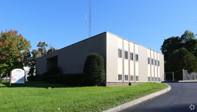

Property Detail
3650 James St
311500-025-000-0004-003-000-0000
FL PT ML41 112X234.87.L12X32 FR
Officebuilding
Onondaga
27
New York
B and X Area of moderate flood hazard, usually the area between the limits of the 100-year and 500-year floods.
3.000
2025
0.60 AC
2025
Greater Syracuse
001900
Syracuse
8,000 SF
Syracuse, NY
NEARBY LISTINGS FOR SALE OR LEASE
DEMOGRAPHICS near 3650 James St
1 mile
3 mile
5 mile
2025 Total Population
11,083
92,600
195,407
2030 Population
10,864
91,485
193,992
Pop Growth 2025-2030
(1.98%)
(1.20%)
(0.72%)
Average Age
41
38
38
2025 Total Households
5,174
37,373
79,002
HH Growth 2025-2030
(2.11%)
(1.26%)
(0.78%)
Median Household Inc
$64,981
$56,144
$57,079
Avg Household Size
2.10
2.20
2.20
2025 Avg HH Vehicles
1.00
1.00
1.00
Median Home Value
$144,660
$159,055
$166,031
Median Year Built
1949
1950
1953
Nearby Places
Map Layers
Map Styles
 Street
 Aerial
Layers
 Traffic
 Biking
Places
Listings with unknown addresses are not visible on the map
- Restaurants
- Banks
- Shops
- Fitness
- Groceries
PUBLIC TRANSPORTATION
COMMUTER RAIL
Drive
Walk
Distance
11 min
5.0 mi
AIRPORT
Syracuse Hancock International
Drive
Walk
Distance
Syracuse Hancock International
16 min
7.9 mi
SALE & LEASE HISTORY
LISTING DATE
SALE/LEASE

Jan 30, 2025
For Lease
Nearby Properties
Address
Land Use
TOTAL SIZE
Lot Size
Zoning
Address
Land Use
TOTAL SIZE
Lot Size
Zoning
508,658 SF
2.23 AC
25
Address
Land Use
TOTAL SIZE
Lot Size
Zoning
826,528 SF
2.28 AC
06 - INDUS
Address
Land Use
TOTAL SIZE
Lot Size
Zoning
269,030 SF
11.90 AC
05 - COMME
Address
Land Use
TOTAL SIZE
Lot Size
Zoning
72,200 SF
12.39 AC
06 - INDUS
Address
Land Use
TOTAL SIZE
Lot Size
Zoning
354,492 SF
6.90 AC
25
Address
Land Use
TOTAL SIZE
Lot Size
Zoning
409,062 SF
10
Address
Land Use
TOTAL SIZE
Lot Size
Zoning
218,051 SF
2.32 AC
25
Address
Land Use
TOTAL SIZE
Lot Size
Zoning
38,693 SF
102.34 AC
05 - COMME
Address
Land Use
TOTAL SIZE
Lot Size
Zoning
24,360 SF
3.99 AC
10
Address
Land Use
TOTAL SIZE
Lot Size
Zoning
414,700 SF
1.94 AC
07 - MIXED
Address
Land Use
TOTAL SIZE
Lot Size
Zoning
2,709 SF
39.74 AC
06 - INDUS
Address
Land Use
TOTAL SIZE
Lot Size
Zoning
224,736 SF
2.48 AC
10
Address
Land Use
TOTAL SIZE
Lot Size
Zoning
569,463 SF
94.77 AC
06 - INDUS
Address
Land Use
TOTAL SIZE
Lot Size
Zoning
164,837 SF
0.66 AC
10
Address
Land Use
TOTAL SIZE
Lot Size
Zoning
105,004 SF
2.81 AC
25
Address
Land Use
TOTAL SIZE
Lot Size
Zoning
165,800 SF
1.27 AC
25
Address
Land Use
TOTAL SIZE
Lot Size
Zoning
12,836 SF
148.95 AC
06 - INDUS
Address
Land Use
TOTAL SIZE
Lot Size
Zoning
296,703 SF
1.48 AC
25
Address
Land Use
TOTAL SIZE
Lot Size
Zoning
307,860 SF
1.17 AC
25
Address
Land Use
TOTAL SIZE
Lot Size
Zoning
116,580 SF
18.46 AC
06 - INDUS
Address
Land Use
TOTAL SIZE
Lot Size
Zoning
278,208 SF
1.92 AC
25
Address
Land Use
TOTAL SIZE
Lot Size
Zoning
134,400 SF
1.18 AC
25
Address
Land Use
TOTAL SIZE
Lot Size
Zoning
194,261 SF
2.62 AC
25
Address
Land Use
TOTAL SIZE
Lot Size
Zoning
17,388 SF
26.51 AC
07 - MIXED
Address
Land Use
TOTAL SIZE
Lot Size
Zoning
174,750 SF
10.40 AC
06 - INDUS
Address
Land Use
TOTAL SIZE
Lot Size
Zoning
876,645 SF
51.07 AC
05 - COMME
Address
Land Use
TOTAL SIZE
Lot Size
Zoning
110,105 SF
26.68 AC
06 - INDUS
Address
Land Use
TOTAL SIZE
Lot Size
Zoning
169,752 SF
12.81 AC
04 - FARM
Address
Land Use
TOTAL SIZE
Lot Size
Zoning
104,400 SF
12.84 AC
06 - INDUS
Address
Land Use
TOTAL SIZE
Lot Size
Zoning
217,709 SF
34.53 AC
01 - NOT Z
The World's #1 Commercial Real Estate Marketplace
Connect with us
© 2026 CoStar Group
The information above has been obtained from sources believed reliable. While we do not doubt its accuracy we have not verified it and make no guarantee, warranty or representation about it. It is your responsibility to independently confirm its accuracy and completeness. Any projections, opinions, assumptions, or estimates used are for example only and do not represent the current or future performance of the property. The value of this transaction to you depends on tax and other factors which should be evaluated by your tax, financial, and legal advisors. You and your advisors should conduct a careful, independent investigation of the property to determine to your satisfaction the suitability of the property for your needs.