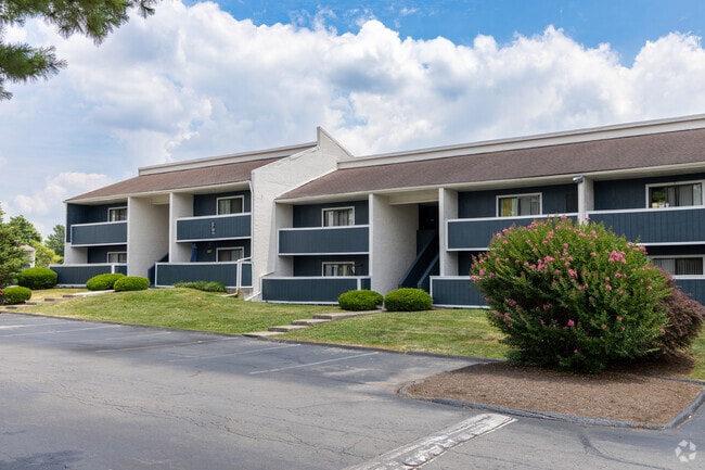
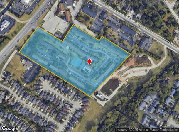
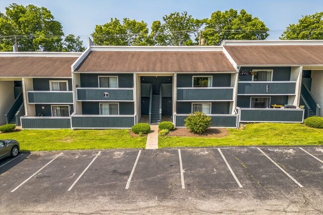
Property Record
3650 Tates Creek Rd, Lexington, KY 40517
NEARBY LISTINGS FOR SALE OR LEASE
-
-
View all Lexington listings for sale on LoopNet.com
Property Detail
3650 Tates Creek Rd
15104000
Louis Mulloy Prop
Apartment
A-514 LOUIS MULLOY PROPERTY LOT; BOOK: 3503 PAGE: 100
X
Fayette
2100670226F
Kentucky
2025
10.45 AC
2025
Southeast Lexington
004001
Lexington/Fayette
27,648 SF
Lexington-Fayette, KY
DEMOGRAPHICS near 3650 Tates Creek Rd
1 Mile
3 Mile
5 Mile
2024 Total Population
21,196
103,710
217,549
2029 Population
21,142
103,282
217,314
Pop Growth 2024-2029
(0.25%)
(0.41%)
(0.11%)
Average Age
36
39
38
2024 Total Households
10,065
45,741
93,787
HH Growth 2024-2029
(0.29%)
(0.44%)
(0.12%)
Median Household Inc
$45,818
$62,633
$60,767
Avg Household Size
2.00
2.20
2.20
2024 Avg HH Vehicles
1.00
2.00
2.00
Median Home Value
$168,954
$251,713
$266,282
Median Year Built
1979
1981
1982
Nearby Places
Map Layers
Map Styles
 Street
 Aerial
- Restaurants
- Banks
- Shops
- Fitness
- Groceries
PUBLIC TRANSPORTATION
AIRPORT
Blue Grass
DRIVE
WALK
Distance
Blue Grass
20 min
11.9 mi
Freight Ports
Port of Toledo
DRIVE
WALK
Distance
Port of Toledo
342 min
292.5 mi
Nearby Properties
Address
Land Use
TOTAL SIZE
Lot Size
Zoning
Address
Land Use
TOTAL SIZE
Lot Size
Zoning
635,961 SF
23.52 AC
P-1
Address
Land Use
TOTAL SIZE
Lot Size
Zoning
76,441 SF
63.86 AC
A-U
Address
Land Use
TOTAL SIZE
Lot Size
Zoning
319,500 SF
0.25 AC
P-1
Address
Land Use
TOTAL SIZE
Lot Size
Zoning
318,370 SF
17.79 AC
B-6P
Address
Land Use
TOTAL SIZE
Lot Size
Zoning
301,644 SF
38.07 AC
R-1C
Address
Land Use
TOTAL SIZE
Lot Size
Zoning
4,299 SF
18.43 AC
R-4
Address
Land Use
TOTAL SIZE
Lot Size
Zoning
8,001 SF
32.59 AC
MU-3
Address
Land Use
TOTAL SIZE
Lot Size
Zoning
144,866 SF
14.83 AC
B-6P
Address
Land Use
TOTAL SIZE
Lot Size
Zoning
238,393 SF
9.83 AC
B-6P
Address
Land Use
TOTAL SIZE
Lot Size
Zoning
156,270 SF
11.18 AC
R-1C
Address
Land Use
TOTAL SIZE
Lot Size
Zoning
5,650 SF
22.46 AC
R-3
Address
Land Use
TOTAL SIZE
Lot Size
Zoning
22.10 AC
R-3
Address
Land Use
TOTAL SIZE
Lot Size
Zoning
12,767 SF
14.39 AC
R-3
Address
Land Use
TOTAL SIZE
Lot Size
Zoning
41,040 SF
14.77 AC
R-4
Address
Land Use
TOTAL SIZE
Lot Size
Zoning
184,756 SF
4.43 AC
MU-3
Address
Land Use
TOTAL SIZE
Lot Size
Zoning
17.20 AC
R-4
Address
Land Use
TOTAL SIZE
Lot Size
Zoning
91,484 SF
14.72 AC
B-6P
Address
Land Use
TOTAL SIZE
Lot Size
Zoning
7,402 SF
18.83 AC
R-4
Address
Land Use
TOTAL SIZE
Lot Size
Zoning
137,905 SF
23.79 AC
B-6P
Address
Land Use
TOTAL SIZE
Lot Size
Zoning
59,586 SF
5.37 AC
R-4
Address
Land Use
TOTAL SIZE
Lot Size
Zoning
4,859 SF
20.45 AC
R-3
Address
Land Use
TOTAL SIZE
Lot Size
Zoning
6.25 AC
A-U
Address
Land Use
TOTAL SIZE
Lot Size
Zoning
28,776 SF
13.83 AC
B-1
Address
Land Use
TOTAL SIZE
Lot Size
Zoning
73,590 SF
13.31 AC
R-1T
Address
Land Use
TOTAL SIZE
Lot Size
Zoning
25,880 SF
0.78 AC
P-1
Address
Land Use
TOTAL SIZE
Lot Size
Zoning
222,168 SF
26.49 AC
B-6P
Address
Land Use
TOTAL SIZE
Lot Size
Zoning
160,800 SF
74.22 AC
R-1C
Address
Land Use
TOTAL SIZE
Lot Size
Zoning
14,928 SF
8.75 AC
R-3
Address
Land Use
TOTAL SIZE
Lot Size
Zoning
4,406 SF
28.12 AC
R-3
Address
Land Use
TOTAL SIZE
Lot Size
Zoning
2,770 SF
15.20 AC
R-4
The World's #1 Commercial Real Estate Marketplace
Connect with us
© 2026 CoStar Group
The information above has been obtained from sources believed reliable. While we do not doubt its accuracy we have not verified it and make no guarantee, warranty or representation about it. It is your responsibility to independently confirm its accuracy and completeness. Any projections, opinions, assumptions, or estimates used are for example only and do not represent the current or future performance of the property. The value of this transaction to you depends on tax and other factors which should be evaluated by your tax, financial, and legal advisors. You and your advisors should conduct a careful, independent investigation of the property to determine to your satisfaction the suitability of the property for your needs.