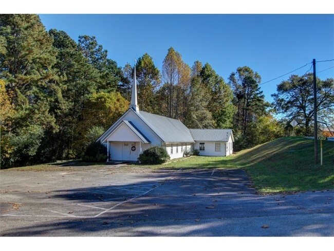
Property Record
3651 Browns Bridge Rd, Gainesville, GA 30504

Save to a Folder
{{folder.Name}}
{{folder.ListingIds.length}} Properties
{{folder.ListingIds.length}} Property
Create a New Folder
Property Detail
3651 Browns Bridge Rd
08-00034-02-001A
BROWNS BRIDGE ROAD
Religious
Hall
AR-1
Georgia
B and X Area of moderate flood hazard, usually the area between the limits of the 100-year and 500-year floods.
3.77 AC
0
Gainesville/Hall County
2025
Atlanta
001006
Gainesville, GA
3,600 SF
NEARBY LISTINGS FOR SALE OR LEASE
DEMOGRAPHICS near 3651 Browns Bridge Rd
1 mile
3 mile
5 mile
2025 Total Population
3,684
31,722
76,358
2030 Population
3,973
34,502
83,067
Pop Growth 2025-2030
+ 7.84%
+ 8.76%
+ 8.79%
Average Age
49
39
38
2025 Total Households
1,528
11,638
27,117
HH Growth 2025-2030
+ 7.85%
+ 8.80%
+ 8.88%
Median Household Inc
$86,142
$69,979
$71,513
Avg Household Size
2.40
2.70
2.70
2025 Avg HH Vehicles
2.00
2.00
2.00
Median Home Value
$483,435
$363,368
$372,464
Median Year Built
1994
1996
1993
Nearby Places
Map Layers
Map Styles
 Street
 Aerial
Layers
 Traffic
 Biking
Places
Listings with unknown addresses are not visible on the map
- Restaurants
- Banks
- Shops
- Fitness
- Groceries
PUBLIC TRANSPORTATION
COMMUTER RAIL
Gainesville Amtrak Station (Crescent - Amtrak)
Drive
Walk
Distance
Gainesville Amtrak Station (Crescent - Amtrak)
10 min
5.6 mi
Freight Ports
Georgia Ports - Savannah
Drive
Walk
Distance
Georgia Ports - Savannah
325 min
256.2 mi
SALE & LEASE HISTORY
LISTING DATE
SALE/LEASE

Sep 23, 2016
For Sale
Nearby Properties
Address
Land Use
TOTAL SIZE
Lot Size
Zoning
Address
Land Use
TOTAL SIZE
Lot Size
Zoning
66,720 SF
27.49 AC
PUD
Address
Land Use
TOTAL SIZE
Lot Size
Zoning
157,050 SF
144.96 AC
N-B
Address
Land Use
TOTAL SIZE
Lot Size
Zoning
92,448 SF
24.25 AC
PUD
Address
Land Use
TOTAL SIZE
Lot Size
Zoning
342,720 SF
22.95 AC
PUD
Address
Land Use
TOTAL SIZE
Lot Size
Zoning
3,620 SF
20.20 AC
PUD
Address
Land Use
TOTAL SIZE
Lot Size
Zoning
41,471 SF
27.60 AC
G-B/R-1
Address
Land Use
TOTAL SIZE
Lot Size
Zoning
19,875 SF
19.76 AC
R-B
Address
Land Use
TOTAL SIZE
Lot Size
Zoning
1,580 SF
15.85 AC
PUD
Address
Land Use
TOTAL SIZE
Lot Size
Zoning
132,557 SF
32.85 AC
O-I
Address
Land Use
TOTAL SIZE
Lot Size
Zoning
308,672 SF
41.22 AC
L-I
Address
Land Use
TOTAL SIZE
Lot Size
Zoning
6,876 SF
10.64 AC
PRD
Address
Land Use
TOTAL SIZE
Lot Size
Zoning
301,380 SF
16.76 AC
I-1
Address
Land Use
TOTAL SIZE
Lot Size
Zoning
1,558 SF
2.53 AC
L-I
Address
Land Use
TOTAL SIZE
Lot Size
Zoning
37,632 SF
8.52 AC
R-II
Address
Land Use
TOTAL SIZE
Lot Size
Zoning
99,093 SF
10.94 AC
R-B
Address
Land Use
TOTAL SIZE
Lot Size
Zoning
33,351 SF
16.80 AC
R-1
Address
Land Use
TOTAL SIZE
Lot Size
Zoning
3,696 SF
11.89 AC
R-II
Address
Land Use
TOTAL SIZE
Lot Size
Zoning
202,540 SF
R-B
Address
Land Use
TOTAL SIZE
Lot Size
Zoning
67,718 SF
27.31 AC
PUD
Address
Land Use
TOTAL SIZE
Lot Size
Zoning
1,610 SF
6.69 AC
R-II
Address
Land Use
TOTAL SIZE
Lot Size
Zoning
68,214 SF
10.85 AC
O-I
Address
Land Use
TOTAL SIZE
Lot Size
Zoning
178,860 SF
14.72 AC
I-1
Address
Land Use
TOTAL SIZE
Lot Size
Zoning
83,090 SF
11.37 AC
I-1
Address
Land Use
TOTAL SIZE
Lot Size
Zoning
17,500 SF
7.66 AC
G-B
Address
Land Use
TOTAL SIZE
Lot Size
Zoning
10,050 SF
9.60 AC
C-2
Address
Land Use
TOTAL SIZE
Lot Size
Zoning
2,705 SF
8.12 AC
R-II
Address
Land Use
TOTAL SIZE
Lot Size
Zoning
109,621 SF
14.84 AC
R-B
Address
Land Use
TOTAL SIZE
Lot Size
Zoning
6,256 SF
4.45 AC
G-B
Address
Land Use
TOTAL SIZE
Lot Size
Zoning
49,175 SF
6.24 AC
G-B
Address
Land Use
TOTAL SIZE
Lot Size
Zoning
6,816 SF
8.34 AC
R-II
The World's #1 Commercial Real Estate Marketplace
Connect with us
© 2026 CoStar Group
The information above has been obtained from sources believed reliable. While we do not doubt its accuracy we have not verified it and make no guarantee, warranty or representation about it. It is your responsibility to independently confirm its accuracy and completeness. Any projections, opinions, assumptions, or estimates used are for example only and do not represent the current or future performance of the property. The value of this transaction to you depends on tax and other factors which should be evaluated by your tax, financial, and legal advisors. You and your advisors should conduct a careful, independent investigation of the property to determine to your satisfaction the suitability of the property for your needs.