Property Record
3651 Sunset Ave, Rocky Mount, NC 27804


NEARBY LISTINGS FOR SALE OR LEASE
Property Detail
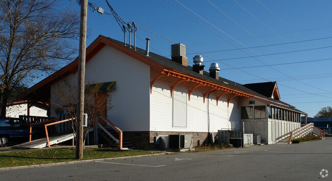
3651 Sunset Ave
3830-12-97-7206
Westridge Village
Communitycenter
83B 1 2, 11 52 AC, B C D E WESTRIDGE VILLAGE AC 1C WESTRIDG VIL SHOP
X
Nash
3720383000K
North Carolina
2025
11.52 AC
2025
Rocky Mount/Wilson
010504
Other Market Areas
46,533 SF
Rocky Mount, NC
DEMOGRAPHICS near 3651 Sunset Ave
1 Mile
3 Mile
5 Mile
2024 Total Population
5,227
28,658
60,256
2029 Population
5,354
29,605
61,977
Pop Growth 2024-2029
+ 2.43%
+ 3.30%
+ 2.86%
Average Age
44
42
41
2024 Total Households
2,290
12,572
25,572
HH Growth 2024-2029
+ 2.36%
+ 3.22%
+ 2.84%
Median Household Inc
$69,901
$57,881
$49,371
Avg Household Size
2.20
2.20
2.30
2024 Avg HH Vehicles
2.00
2.00
2.00
Median Home Value
$183,189
$160,715
$145,850
Median Year Built
1980
1984
1980
Nearby Places
Map Layers
Map Styles
 Street
 Aerial
- Restaurants
- Banks
- Shops
- Fitness
- Groceries
PUBLIC TRANSPORTATION
COMMUTER RAIL
DRIVE
WALK
Distance
8 min
4.1 mi
AIRPORT
Pitt-Greenville
DRIVE
WALK
Distance
Pitt-Greenville
56 min
46.0 mi
Nearby Properties
Address
Land Use
TOTAL SIZE
Lot Size
Zoning
Address
Land Use
TOTAL SIZE
Lot Size
Zoning
133,154 SF
70.45 AC
MA
Address
Land Use
TOTAL SIZE
Lot Size
Zoning
9,384 SF
95.52 AC
R30
Address
Land Use
TOTAL SIZE
Lot Size
Zoning
129,595 SF
11.35 AC
B2CU
Address
Land Use
TOTAL SIZE
Lot Size
Zoning
130,639 SF
60.52 AC
A1M
Address
Land Use
TOTAL SIZE
Lot Size
Zoning
21,824 SF
75.42 AC
IM
Address
Land Use
TOTAL SIZE
Lot Size
Zoning
104,995 SF
16.01 AC
Address
Land Use
TOTAL SIZE
Lot Size
Zoning
10,632 SF
16.61 AC
R6
Address
Land Use
TOTAL SIZE
Lot Size
Zoning
79,027 SF
33.37 AC
R10
Address
Land Use
TOTAL SIZE
Lot Size
Zoning
98,831 SF
5.40 AC
I
Address
Land Use
TOTAL SIZE
Lot Size
Zoning
29,504 SF
18.61 AC
Address
Land Use
TOTAL SIZE
Lot Size
Zoning
65,826 SF
16.77 AC
Address
Land Use
TOTAL SIZE
Lot Size
Zoning
204,903 SF
23.07 AC
Address
Land Use
TOTAL SIZE
Lot Size
Zoning
85,766 SF
4.61 AC
B5
Address
Land Use
TOTAL SIZE
Lot Size
Zoning
98,065 SF
6.14 AC
I
Address
Land Use
TOTAL SIZE
Lot Size
Zoning
73,338 SF
2.81 AC
B5CU
Address
Land Use
TOTAL SIZE
Lot Size
Zoning
16,110 SF
17.49 AC
MA
Address
Land Use
TOTAL SIZE
Lot Size
Zoning
32,051 SF
18.50 AC
R6
Address
Land Use
TOTAL SIZE
Lot Size
Zoning
15,650 SF
32.25 AC
R10
Address
Land Use
TOTAL SIZE
Lot Size
Zoning
59,236 SF
2.18 AC
B5M
Address
Land Use
TOTAL SIZE
Lot Size
Zoning
51,543 SF
9.61 AC
I
Address
Land Use
TOTAL SIZE
Lot Size
Zoning
6,253 SF
16.22 AC
A1
Address
Land Use
TOTAL SIZE
Lot Size
Zoning
135,400 SF
21.45 AC
B2
Address
Land Use
TOTAL SIZE
Lot Size
Zoning
25,936 SF
22.35 AC
R15
Address
Land Use
TOTAL SIZE
Lot Size
Zoning
62,024 SF
5.39 AC
B5
Address
Land Use
TOTAL SIZE
Lot Size
Zoning
19,152 SF
9.56 AC
I
Address
Land Use
TOTAL SIZE
Lot Size
Zoning
7,022 SF
14.89 AC
A1
Address
Land Use
TOTAL SIZE
Lot Size
Zoning
47,410 SF
2.58 AC
B5CU
Address
Land Use
TOTAL SIZE
Lot Size
Zoning
129,264 SF
31.28 AC
B3
Address
Land Use
TOTAL SIZE
Lot Size
Zoning
253,009 SF
52.80 AC
B3
Address
Land Use
TOTAL SIZE
Lot Size
Zoning
63,276 SF
3.07 AC
I
The World's #1 Commercial Real Estate Marketplace
Connect with us
© 2025 CoStar Group
The information above has been obtained from sources believed reliable. While we do not doubt its accuracy we have not verified it and make no guarantee, warranty or representation about it. It is your responsibility to independently confirm its accuracy and completeness. Any projections, opinions, assumptions, or estimates used are for example only and do not represent the current or future performance of the property. The value of this transaction to you depends on tax and other factors which should be evaluated by your tax, financial, and legal advisors. You and your advisors should conduct a careful, independent investigation of the property to determine to your satisfaction the suitability of the property for your needs.